Amberd fortress: history on the slopes of Aragats
A fortress at the edge of the alpine world
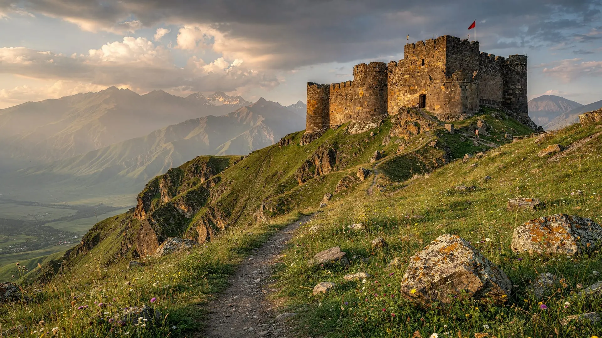
Amberd fortress stands at 2300m on the Aragats massif — high enough that snow still patches the surrounding hills in late June, high enough that Yerevan’s summer heat is replaced by cool mountain air, high enough that the views south over the Araratian plain carry an unusual intimacy with the sky. The fortress name may derive from “fortress in the clouds” in Armenian (amba meaning “cloud”), and on overcast days the etymology makes immediate sense.
The site is one of the finest combinations of medieval architecture and mountain landscape in Armenia. Most visitors encounter it as a stop on the road to Lake Kari and the Aragats hiking trailheads, but Amberd deserves more than a 30-minute windshield-tour stop. The fortress-palace, the adjacent church, and the dramatic topographic setting — on a narrow spur between two river gorges — reward slow exploration.
Historical background
Amberd was built and used from approximately the 7th to the 14th century AD, with its most significant period of construction and habitation during the 10th–11th centuries under the Pahlavid dynasty and subsequently the Zakarian (Zakharids) princes who controlled much of northern and central Armenia in the early medieval period.
The fortress functioned as both a military strongpoint and a noble residence — a palace-fortress controlling the upper Amberd river valley and the approach routes to the Aragats highland pastures. The elevation itself was part of the defensive logic: an enemy force ascending the exposed slopes to 2300m would arrive exhausted and exposed long before reaching the walls.
The main fortress structure: The outer walls and towers, built in dark volcanic tuff, enclosed a substantial residential complex. The surviving walls reach 5–8m in height in the best-preserved sections. The north-east corner tower and the main gate section are the most complete surviving elements.
Amberd church (1026 AD): The single-nave church attached to the fortress was built in 1026 by the Pahlavid prince Vahram Pahlavuni. It is one of the best-preserved structures on the site — the façade retains original carved stone ornament around the doorway and the blind arcading on the walls. The church was built in the classic Armenian single-nave cathedral plan with a distinctive conical drum and dome.
The gorge setting: The fortress occupies a triangular spur above the confluence of the Amberd and Arkashen rivers. The gorges on two sides provided natural defensive barriers — you can walk to the gorge edge and look down 50–60m to the river below. The only approach to the fortress was from the south, which is where the main defensive walls were concentrated.
The Mongol destruction: Amberd was destroyed by Mongol forces in 1236 during the general devastation of medieval Armenian urban and ecclesiastical life. It was never fully rebuilt afterward; the ruins you see today reflect that catastrophic 13th-century event.
What to see and how to spend your time
Allow at least 45–60 minutes at the site:
Main fortress walls: Walk the perimeter of the surviving walls, entering through the reconstructed main gate area. The interior is an open field now, but the wall heights and the corner towers give a strong sense of the original scale.
Amberd church: The church is active — you may encounter candles burning and Armenians praying. Respectful entry is welcome; dress modestly (shoulders and knees covered). Look for the carved crosses and inscriptions on the exterior stonework, and for the light effects through the narrow windows at different times of day.
Gorge viewpoints: Walk to the northern and western edges of the spur for the most dramatic views. The gorge below is steep and green (forest on the lower slopes), contrasting with the volcanic rock of the fortress above. On clear days, the southern view extends across the Araratian plain.
The surrounding landscape: The meadows around the fortress are excellent for wildflowers in June and early July. Shepherd’s camps appear nearby in summer, and you may see large flocks of sheep on the slopes.
Photography: Best light is morning or evening. The fortress walls face south-west, catching afternoon light well. The church is best photographed from below the gorge edge (a short scramble from the main site), which reveals the full architectural composition with Aragats peaks behind.
Combining Amberd with Lake Kari and Aragats hiking
Amberd sits at 2300m on the same road that continues up to Lake Kari at 3200m. The most natural itinerary from Yerevan:
- Depart Yerevan early (7–8am)
- Stop at Hovhannavank monastery (30 min, on the way)
- Continue to Amberd fortress (45–60 min)
- Continue up to Lake Kari
- Hike the Aragats southern summit (5–6h round trip)
- Return to Yerevan via the same route
This makes a very full day (15+ hours from Yerevan departure to return) but covers an extraordinary density of Aragatsotn highlights. For a more relaxed approach, combine Amberd with the Armenian Alphabet Monument (at Artashavan, 20 min from Amberd by road) and the monasteries of Hovhannavank and Saghmosavank, leaving Aragats summiting for a separate day.
The Mount Aragats four-peaks guide has detailed logistics for the summit components. The day trip guide to Aragats and Amberd from Yerevan covers the combined day in detail.
Getting there from Yerevan
By car: From Yerevan take the M3 highway north toward Aparan. After Aparan, follow signs for Aragats and Byurakan (not toward the town of Byurakan itself but the higher road toward Aragats). The road to Amberd branches east from the main Aragats road; signs are present but can be small. GPS coordinates: approximately 40.39°N, 44.26°E. Total drive: 1h 20min–1h 30min from Yerevan.
The road to Amberd is paved to the site; no 4WD required unless there is fresh snow. The last 3 km can be rough but manageable by standard car.
By organised tour: Most Yerevan operators offer half-day or full-day tours covering Amberd + Aragats. The day trip to Aragats and Amberd from Yerevan is one of the most popular options for visitors without a car.
The private Aragats south summit day hike from Yerevan passes Amberd en route to Lake Kari and typically includes a brief stop — convenient for combining the fortress visit with the summit hike.
Altitude and practical considerations
At 2300m, Amberd is noticeably cooler than Yerevan throughout the year. In summer (July–August), temperatures at the fortress are typically 15–22°C when Yerevan is sweltering at 35°C. Bring a light layer even on summer visits. In shoulder months (April–May, October), a warm jacket is appropriate.
Snow is possible at Amberd from October to May; the site is most reliably accessible June–September. The church is open year-round, but the surrounding meadows and gorge paths are most enjoyable in the snow-free months.
There are no food or water facilities at or near Amberd. Bring a picnic from Yerevan or stop at one of the roadside eateries in Byurakan village (20 min below) for basic Armenian food.
Amberd in the context of Aragatsotn
Aragatsotn province is one of the most concentrated areas of Armenian heritage in the country. Within 40 km of Amberd: Hovhannavank and Saghmosavank monasteries (the Kasakh gorge trail connects them on foot), the Armenian Alphabet Monument at Artashavan, Byurakan observatory (7th-largest optical telescope in the world when constructed), and the volcanic summit of Aragats itself.
For mountain context, the Caucasus mountains in Armenia guide explains how Aragats and the volcanic landscape around Amberd fit into the broader geological and geographical picture.
Frequently asked questions about Amberd fortress
Is Amberd fortress in good condition?
Partially. The church (1026 AD) is well preserved and active. The fortress walls survive to 5–8m height in sections. Significant portions of the palace-fortress complex have collapsed. What survives is impressive and gives a strong sense of the original site; it is not, however, a fully intact medieval fortress in the manner of, say, a European castle with complete towers and halls.
Can I hike to Amberd rather than driving?
Yes, from Byurakan village (1400m). The approach by foot from Byurakan takes about 2–3 hours one-way, following the road with some shortcuts through the meadows. This adds significant elevation gain to a day that already includes Aragats hiking, so most visitors drive to the site.
Is there a guide available at Amberd?
No official guide is permanently posted at the site. The church caretaker is sometimes present and can provide basic information. For a more informative visit, hire a Yerevan-based guide who specialises in Aragatsotn. The Armenia Alphabet Monument and Aragats day trip organised tours typically include guide commentary at Amberd.
How does Amberd compare to other Armenian fortress sites?
Amberd is in the top tier of Armenian fortress sites for architectural quality and setting. It compares well with Bjni fortress (less complete but similar drama), Tatev monastery fortress (better preserved but at lower altitude), and Akhtala (similar medieval period but different character). The combination of the 1026 church and the mountain setting makes Amberd unique.
What is the entry fee?
No formal entry fee exists for Amberd. A small donation box may be present at the church. The site is open access year-round.
The historical context: Aragatsotn in the medieval period
The Aragatsotn of the 10th–11th centuries was one of the most culturally and militarily significant provinces of medieval Armenia. The Pahlavid dynasty that built Amberd controlled a territory stretching from the Kasakh river gorge (where Hovhannavank stands) northward across the Aragats massif. They were one of several noble houses that maintained Armenian culture and political continuity during a period when the main Bagratid kingdom in Ani (north-west, now Turkey) was under pressure from Byzantine and later Seljuk expansion.
Amberd’s construction at 2300m — an elevation that required both resources and determination — reflects the political reality of the period. Control of the high pastures of Aragats meant control of the seasonal transhumance routes, the shepherds’ access, and ultimately the surplus that funded both the fortress and the monastery. The Pahlavids who built this complex were not merely warriors; they were landowners extracting value from the volcanic highlands.
The Zakarian/Zakharids who later patronised Hovhannavank and Saghmosavank (in the 12th–13th centuries) were part of the same pattern of Armenian noble-ecclesiastical partnership: nobles funding churches and monasteries in exchange for spiritual legitimacy and the practical benefits of literate, organised monastic communities managing agricultural land.
The 1236 Mongol destruction: evidence in the ruins
The Mongol invasion of 1236 that destroyed Amberd left archaeological evidence still visible in the ruins. Look for fire-blackened stones in the fortress interior — the kind of burning that occurs when wooden roof structures collapse onto stone walls. The scatter pattern of collapsed masonry in the palace area reflects a rapid, violent end: walls pushed inward rather than slowly subsiding over centuries.
Medieval Armenian chronicles (preserved in the Matenadaran manuscripts in Yerevan) describe the Mongol devastation of Armenian highland fortresses with unusual precision. The attack on Amberd is documented as part of the general 1236 campaign; the monastery survived longer in limited use but the main fortress-palace was never rebuilt.
This forensic reading of ruins — understanding the collapse as event rather than mere decay — changes how you walk through the site. The open field inside the walls was once a palace courtyard with wooden-roofed buildings. The absence of roof structures is not the medieval builder’s choice; it is the consequence of a specific afternoon in 1236.
Byurakan village and the astrophysics connection
The village of Byurakan at the foot of the Aragats massif (1400m altitude, 20 min below Amberd by road) is home to one of the most significant astronomical observatories in the former Soviet Union. The Byurakan Astrophysical Observatory, founded by the legendary astronomer Viktor Ambartsumian in 1946, contains several large optical telescopes on its ridge above the village.
The observatory is open to visitors (arrange in advance) and offers evening telescope sessions in the summer months — a remarkable combination with a Aragats hiking day. Byurakan village also has guesthouses that make a practical overnight base for morning summit attempts on Aragats, eliminating the need to drive up from Yerevan on summit day.
The view from the observatory grounds at dusk — Aragats above, the Araratian plain below, Ararat on the horizon — is one of the finest in Armenia. The night sky above Byurakan, at 1400m with minimal light pollution from the village, is exceptional by European standards.
Aragatsotn full-day circuit
For visitors with a car and a full day, the complete Aragatsotn circuit from Yerevan hits all the major highlights:
- 8:30am — Depart Yerevan, heading north on M3
- 9:15am — Hovhannavank monastery (30 min)
- 10:00am — Optional: gorge walk toward Saghmosavank (2h) or drive to Amberd
- 11:00am or 12:00pm — Amberd fortress and church (45–60 min)
- 12:30pm — Drive to Byurakan observatory (20 min below Amberd)
- 1:00pm — Lunch at Byurakan village guesthouse
- 2:00pm — Continue up to Lake Kari if road is open (June–October only)
- 3:00pm — Lake Kari and brief walk (2h)
- 5:00pm — Descend, stop at Armenian Alphabet Monument (Artashavan, 30 min)
- 7:00pm — Return to Yerevan
This circuit is ambitious but entirely achievable for visitors who enjoy full-day road trips. The elevation changes are dramatic — from Yerevan at 900m to Lake Kari at 3200m and back — which means the temperature range across the day can span 25°C. Dress in layers.