Off-road & jeep tours in Armenia: top routes
Why Armenia rewards getting off the tarmac
Armenia’s road network is better than its neighbours on average, but the country’s most extraordinary landscapes are mostly off it. The volcanic highlands that make up the Aragats massif, the Gegham range east of Yerevan, and the Zangezur mountains of Syunik province are accessible only by dirt track, unpaved mountain road, and seasonal jeep trail. These are the landscapes that gave Armenia its reputation in the off-road and overlanding community — dramatic altitude, sparse infrastructure, and scenery that alternates between stark volcanic desert and lush highland meadow.
For visitors without their own 4WD vehicle, several operators in Yerevan run guided off-road day tours and multi-day expeditions. For those with capable vehicles, this guide covers the best self-drive routes and what conditions to expect.
Route 1: The Aragats loop (Lake Kari and Amberd)
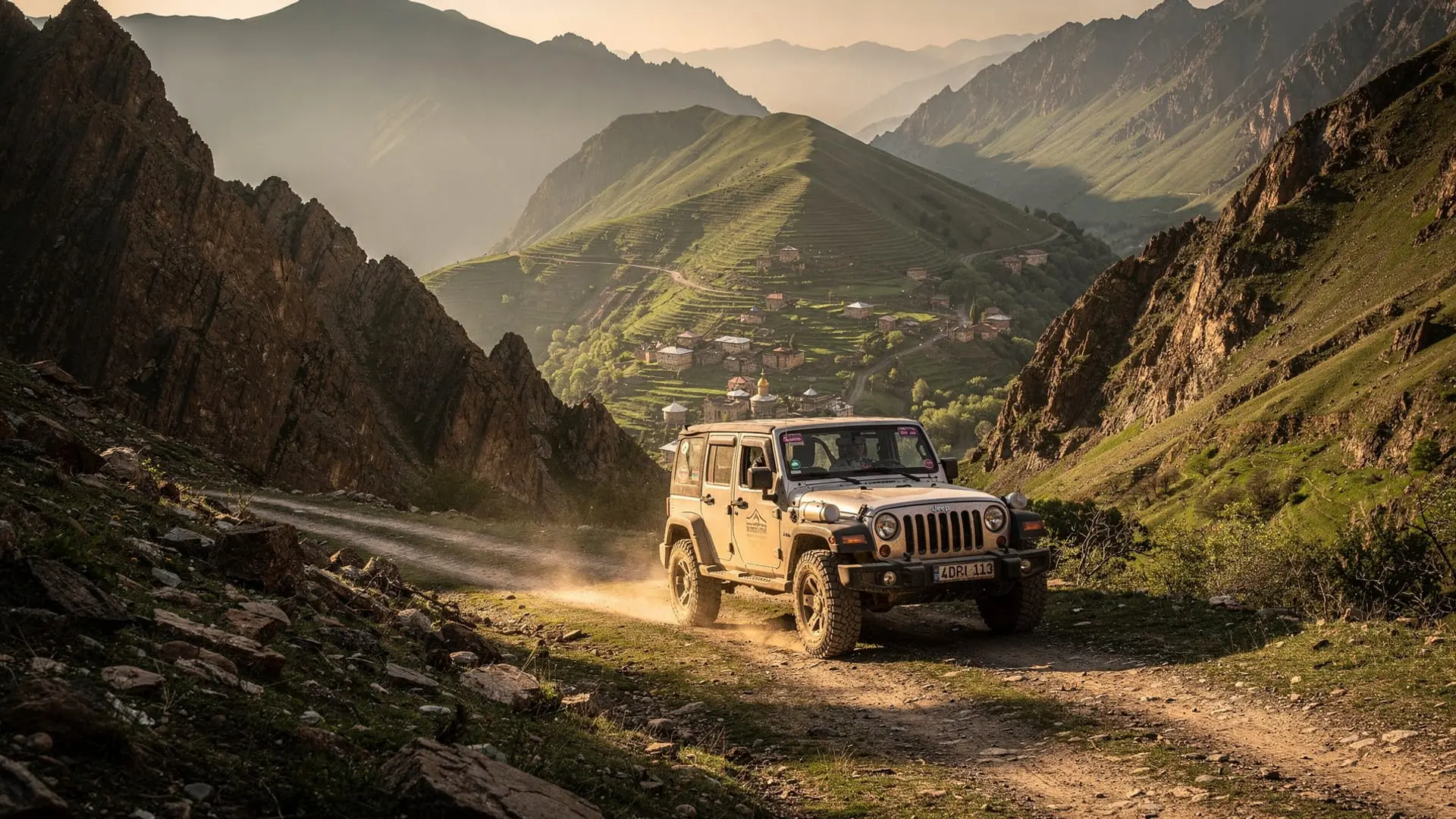
The most accessible and popular off-road route in Armenia. Starting from Ohanavan village (70 km north of Yerevan on the paved road through Aparan), the dirt track climbs through the Armenian Alphabet Monument at Artashavan and continues steeply up the Aragats massif to Amberd fortress (2,300 m) and then to Lake Kari (3,190 m).
Distance: Approximately 60 km off-road from Ohanavan to Lake Kari and back Elevation gain: About 2,100 m from the paved road to the lake Vehicle requirement: 4WD essential from Amberd upward; high-clearance AWD possible on dry days in summer Open season: Late June to early September (road can be snowbound into late June) Highlights:
- Amberd fortress (10th–13th century, combined with Vahramashen church) on the volcanic slope
- The drive above the treeline into open alpine terrain
- Lake Kari in its volcanic bowl with Aragats’ four peaks looming above
- Option to attempt the southern summit hike (4,022 m, 2–3 hours return from the lake)
- View of Mount Ararat from the western slopes on clear days
Operators: Several Yerevan-based tour operators include Aragats summit and Lake Kari in their off-road programmes.
Book a day tour to Amberd fortress, Mount Aragats, and Lake KariRoute 2: Azhdahak volcano circuit (Gegham highlands)
The Gegham volcanic range lies directly east of Yerevan, forming the natural wall between the Ararat plain and Lake Sevan. It is one of the least-visited landscapes in Armenia despite being within 40 km of the capital — because it is entirely off-road and has essentially no tourist infrastructure.
Azhdahak (3,598 m) is the range’s highest peak and has a seasonal crater lake that fills with snowmelt in spring and early summer, often containing patches of floating ice as late as June. Petroglyphs from the Bronze Age cover rock surfaces on the upper approach — deer, hunters, geometric patterns scratched into dark volcanic rock that is otherwise indistinguishable from the surrounding landscape.
Route: From Garni (25 km from Yerevan), a dirt road climbs into the Gegham highlands via Goght village. The route is an extended highland traverse to the Azhdahak summit area. Distance: 50–70 km off-road from Garni Vehicle requirement: 4WD essential; this route is rough and navigational skill required Best time: June–August (crater lake is largest in June–early July) Highlights: Petroglyphs, crater lake, panoramic view of Aragats, Ararat, Sevan, and the entire Ararat plain
Book an Azhdahak mountain hike and jeep ride day tour from YerevanRoute 3: The Selim-Sevan highland road (Vayots Dzor)
This is one of the most spectacular off-road drives in the South Caucasus and arguably the one that makes the most of Armenia’s highland geography. The route connects the wine village of Areni in Vayots Dzor with Lake Sevan via the Selim Pass (2,400 m) and the medieval Selim Caravanserai — one of the best-preserved Silk Road rest stops in Armenia, built in 1332 and now surrounded by nothing but volcanic highland and endless sky.
Route: Areni → Yeghegnadzor → Selim Pass → Selim Caravanserai → Martuni → Lake Sevan (southern shore) Distance: ~100 km, of which about 30 km are unpaved or poor road around the Selim Pass Vehicle requirement: High-clearance AWD in summer; 4WD recommended, essential in wet or early-season conditions Open season: May–October; the Selim Pass can be blocked by snow into May Highlights: The caravanserai interior (open to visitors, no fee), the volcanic highland plateau, views of the Vardenis range, connection between the wine country and Lake Sevan in a single day
This route is the backbone of the Armenia off-road and wine itinerary for visitors combining Areni/Vayots Dzor with Sevan.
Book an off-road tour from Yerevan to Sevan, Areni, and the Selim CaravanseraiRoute 4: Smbataberd off-road (Vayots Dzor highlands)
Smbataberd is a medieval fortress at 2,000 m in the Vayots Dzor highlands, overlooking the Arpa River valley. Reaching it requires a rough 4WD track from Artabuynk village or a 2-hour hike from the paved road. The fortress itself is ruined but intact enough to walk around, and the views across the highland plateau are exceptional.
This route is often combined with Zorats (the fortress church) and Khor Virap in a long Vayots Dzor/Ararat loop. It is particularly popular with the off-road community because it combines historical sites with genuine terrain challenge.
Book a Smbataberd and Zorats Church off-road day trip from YerevanRoute 5: Ijevan off-road to Mount Vitasar (Tavush)
In the northeast, the forested hills around Ijevan give way to a series of high ridges that are accessible only on foot or by 4WD. Mount Vitasar (2,319 m) above Ijevan offers a ridge drive through forest and then above the treeline, with views east into Georgia and north toward the Greater Caucasus.
This route is less well-known than the Aragats or Gegham routes but appeals to visitors who want to combine the forest character of Tavush with genuine off-road elevation. A specialised tour operator in Ijevan runs this as a half-day experience.
Practical information for self-drive off-road
Vehicle recommendations: Toyota Land Cruiser 70/80/200 series, Mitsubishi Pajero, Nissan Patrol, UAZ (local preference). Lift kits help but are not essential for most routes. All-terrain tyres are recommended over highway tyres for the Aragats and Azhdahak routes.
Spare equipment: Always carry a spare tyre (not a space-saver), tow rope, jack, and basic tool kit. Mobile signal exists on most accessible routes but disappears quickly once off major tracks.
Maps: Google Maps does not reliably show off-road tracks in Armenia. Download the relevant area on Maps.me or OsmAnd before departing — OpenStreetMap coverage of Armenian highland tracks is reasonably good.
Fuel: Fill up in Yerevan or the last major town before your route. No fuel is available on the routes above.
Guides: For Aragats and Azhdahak in particular, consider hiring a local guide for the first time — the track network is complex and conditions change rapidly with weather.
Frequently asked questions about off-road tours in Armenia
Can I rent a 4WD vehicle in Armenia?
Yes. Several Yerevan rental companies offer Toyota Land Cruisers, Mitsubishi Pajeros, and Niva/UAZ vehicles with or without drivers. Renting with a driver is common and often not significantly more expensive than solo rental when you factor in the navigation knowledge. For Aragats and Azhdahak routes specifically, a driver-guide is strongly recommended for first-time visitors.
What is the best off-road route for a first-time visitor?
The Aragats loop (Ohanavan → Amberd → Lake Kari) is the most forgiving in terms of navigation — the track is relatively well-defined — and offers the most dramatic scenery per kilometre. Budget a full day including the summit hike option.
When is the off-road season in Armenia?
June through September for the high routes (Aragats, Azhdahak). The Selim Pass can be attempted in May and October with caution. Lower-altitude routes like Smbataberd are accessible from April. Winter off-roading exists but is a specialist endeavour.
Are the roads dangerous?
The risks are typical of mountain off-road driving worldwide: track conditions vary with weather, sudden changes in visibility occur, and mechanical breakdowns in remote areas require self-sufficiency. The Armenian mountain routes are not technically extreme — no river crossings, no technical rock features — but altitude and remoteness mean that breakdowns or weather changes should be taken seriously.
What is included in a guided off-road tour?
Most Yerevan operators include: 4WD vehicle, driver-guide, petrol, basic first aid kit, and a stop for lunch (either packed or at a roadside facility). Some include accommodation for multi-day routes. Confirm what is included before booking.
The history of off-road access in Armenia
Armenia’s off-road landscape is partly a legacy of Soviet agricultural and military infrastructure. The tracks that now serve as adventure tourism routes were built for practical purposes:
Military roads: The Aragats massif was a Soviet military radar and observation zone. Several of the tracks leading to the high plateau were built or maintained for military vehicle access. These are now the most reliable of the highland tracks.
Collective farm tracks: The Selim Pass road and several routes in Vayots Dzor were maintained for agricultural vehicles moving between highland summer pastures and valley farms. The Selim Caravanserai stands beside one such agricultural road.
Forestry roads: The Tavush forest tracks were built for timber extraction during Soviet industrialisation. Many have grown over and are now walkable or cycleable rather than driveable.
Post-Soviet transition: The economic collapse of the 1990s meant that most track maintenance stopped. Tracks that were graded annually became deeply rutted, overgrown in sections, and in some areas impassable. The good news for off-road enthusiasts is that this creates genuine challenge. The bad news is unpredictability — a track passable in September may not be passable in May after a wet winter.
Multi-day off-road expeditions
For serious off-road enthusiasts, Armenia rewards multi-day expeditions that cannot be done as day trips from Yerevan:
The Zangezur traverse: A 3–4 day expedition from Goris south through the Syunik highlands toward Kapan, using high mountain tracks between villages. This is genuinely remote off-road driving through one of the least-visited but most spectacular landscapes in Armenia. Requires full self-sufficiency.
The Gegham highlands circuit: A 2-day expedition from Yerevan east through the Gegham range (Azhdahak and surrounding highlands), camping on the plateau, and returning via the Martuni road on the southern Sevan shore. Wild camping on the volcanic plateau with petroglyphs visible from camp.
North to south 4WD: An ambitious 5-day route linking Haghpat/Lori in the north with Kapan/Syunik in the south via highland tracks — a spine traverse of the country largely avoiding paved roads.
Vehicle preparation for Armenian off-road
Beyond the standard 4WD requirement, specific preparation helps:
Underbody protection: The rocky tracks on Aragats and in the Gegham highlands can damage exposed fuel tanks and transfer cases. Steel skid plates on the engine, transmission, and fuel tank are recommended for extended expeditions.
Tyre repair kit: A full plug-and-patch kit with a 12V compressor is essential — more useful than a second spare on rock-strewn tracks where sidewall punctures are common.
Recovery gear: Kinetic tow rope, high-lift jack, folding shovel, and traction boards (MaxTrax or equivalent) for the soft sand sections that appear unexpectedly in some highland areas.
Water: Many highland areas have no reliable water sources accessible without filtering. Carry 10+ litres of drinking water per person per day for remote expeditions.
Off-road and the Armenian pastoral landscape
One of the distinctive aspects of off-road driving in Armenia is the frequency of encounters with functioning pastoral practices — shepherd families moving their flocks between seasonal pastures, hay-making operations in highland meadows, and the stone shepherd’s huts (koshara) that dot the highland landscape. These encounters are part of the experience and deserve thoughtful engagement:
Give way to livestock: Flocks of sheep or cattle on mountain tracks have right of way. The shepherd’s dog (Armenian gampr, the native livestock guardian breed — a large, powerful, independent dog that is very good at its job) will bark at your vehicle and may approach it assertively. Stay in the vehicle, do not open windows until the dog is distant, and wait for the shepherd’s signal before proceeding.
Do not disturb encampments: Seasonal shepherd camps in the highlands are working operations. Drive around rather than through them. Stopping to observe is fine but maintain distance.
Water at highland springs: The small spring-fed troughs maintained by shepherds for their animals are for animals, not vehicles or casual use. Springs with flagged poles or fenced areas are typically maintained as domestic water sources for the seasonal population and should not be contaminated by vehicles or waste.
The geological reward of off-road Armenia
The highland tracks of Armenia are essentially a geological education:
The Aragats massif reveals the structure of a shield volcano — the gentle slopes, the layered lava flows visible in road cuts, the scoria and pumice deposits that create the distinctive reddish-black gravel covering the upper slopes.
The Gegham range exposes the record of more recent and violent volcanic activity — lava tubes, pressure ridges, and the petroglyphs carved into the volcanic rock by Bronze Age people who lived in this then-forested landscape.
The Vayots Dzor gorges show the intersection of volcanic and carbonate geology — the dark basalt from volcanic intrusion cutting through older limestone formations, with the hot springs emerging precisely at this geological contact zone.
Driving these landscapes with geological awareness turns the journey into reading — the landscape tells a coherent story if you know the language.