Paragliding in Armenia: where & how
An unexpected paragliding country
Armenia does not appear in the first ten countries most paragliders think of when planning a trip, but it probably should. The country has a combination of geographic and meteorological characteristics that produce excellent flying conditions: a high plateau at 800–2,000 metres with reliable thermal activity from April through October, dramatic ridgelines offering strong ridge lift, and launch sites with unobstructed views of two of the most famous mountains in the world — Aragats (4,090 m, the highest point in Armenia) and Ararat (5,137 m, across the border in Turkey but visible from most of Armenia’s western airspace).
The paragliding infrastructure is modest but established. A small community of local pilots operates in the Aragatsotn province year-round, and several operators run tandem flights for visitors at multiple sites. For licensed pilots bringing their own wing, Armenia offers interesting cross-country routes with few airspace restrictions and relatively uncrowded skies.
Main paragliding sites
Aparan and the Aragatsotn plateau
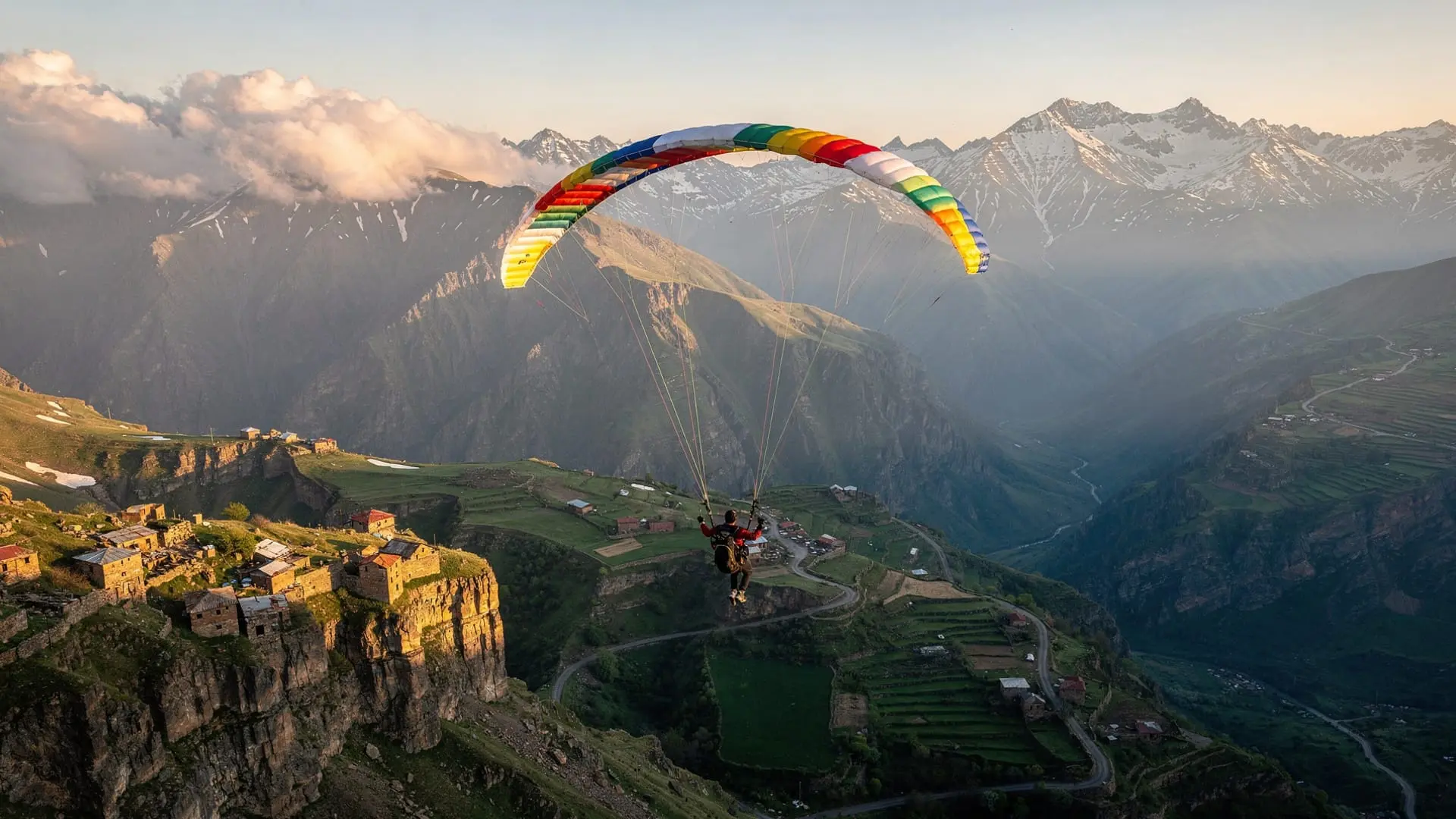
The area around Aparan, a small town 70 km north of Yerevan on the Hrazdan river plateau, is the most developed paragliding zone in Armenia. The broader province of Aragatsotn rewards exploration beyond the skies. The terrain offers:
- Launch altitude: 1,800–2,200 m depending on launch site
- Thermal conditions: Strong afternoon thermals from May through September, reliable cross-country conditions on clear days
- Landing zones: The broad plateau below Aparan has multiple safe landing options
- Views: On a clear day, the flight path offers a line-of-sight across to Mount Ararat (if visibility permits) and the full Aragats massif to the north
- Cross-country potential: Experienced pilots can fly north toward the Aragats slopes or south toward Yerevan; longest routes approach 40–60 km on good days
This is the site most Armenian paragliding operators use as their home base. Tandem flights for visitors depart from here throughout the season, with experienced local pilots guiding passengers on 20–30 minute flights.
Mount Aragats slopes
For pilots wanting altitude, the Aragats massif offers launch sites above 3,000 metres, with significant soaring potential on suitable days. These launches require a 4WD approach or a combined hike-and-fly approach and are best suited to experienced pilots who know the area. Local pilot clubs (based in Yerevan) organise access trips in summer.
Lake Kari at 3,190 m on the southern Aragats slope has been used as a high-altitude launch site by local pilots. The approach from the lake toward the Ararat plain offers one of the most spectacular flight corridors in the South Caucasus.
Yell Extreme Park (Yenokavan)
The tandem paragliding operation at Yell Extreme Park launches from the high ridge above the Yenokavan canyon, offering flights over the Tavush forest valley. This is a different landscape from the Aragatsotn plateau — enclosed, forested, with the river canyon below — and the flight experience is correspondingly more about proximity to the forest than about open-sky distance.
Flight duration: approximately 20–30 minutes. Pre-booking is essential as capacity is strictly limited. Combine with the zipline and ropes course for a full adventure day.
Lake Sevan area
Several operators have run tandem paragliding flights from the hillsides above Lake Sevan’s western shore in summer, with landings on the beach. This is a seasonal, informal operation — the views of the lake from altitude are spectacular but availability is unpredictable. Ask locally in Sevan town or at your hotel whether flights are operating during your visit.
Book a full-day adventure tour including Yenokavan with paragliding option at Yell Extreme ParkTandem flights: what to expect
Tandem paragliding requires no prior experience. You fly as a passenger strapped in front of an experienced pilot, who handles all controls. The pre-flight briefing covers what to expect on launch (a short running start), in the air (mostly sitting and enjoying the view), and on landing (a few running steps). The whole experience from harness-up to landing takes about 45 minutes; the flight itself is typically 20–30 minutes.
Price range: 15,000–25,000 AMD (35–60 EUR) for a tandem flight of 20–30 minutes. Prices vary by operator and location.
Weight and health restrictions: Most operators accept passengers up to 100 kg. No experience required. Passengers with serious heart conditions, pregnancy, or recent back injuries should consult their doctor first. The launches and landings involve minimal physical stress.
Age: Minimum typically 14–16 years with parental consent; some operators accept younger children at the pilot’s discretion.
For licensed paragliders
Armenia has no significant airspace restrictions over most of its territory for recreational paragliding (check NOTAM for any temporary restrictions near Zvartnots airport, which has an extended TMA). The two main clubs to contact for local knowledge are based in Yerevan:
- Armenia Paragliding Federation: The national body for paragliding, based in Yerevan, can connect visiting pilots with local club members and site information.
- Local Facebook groups: The Armenian paragliding community is active on Facebook — searching “paragliding Armenia” will find the current active groups where site conditions and flying windows are shared daily.
For visiting pilots bringing their own equipment:
- Wing storage: Hotel storage or car-boot between flights; no specialist facilities exist
- Gas and transport: Pilots typically coordinate car shuttles for cross-country retrieval through club networks
- Recommended guidebook: No Armenia-specific paragliding guide exists — the knowledge is held within the community. Downloading terrain data into XCTrack or XCSoar is recommended
Season and conditions
April–May: Thermal activity beginning, cooler air reduces convective strength but makes for smooth flights. Good for first-timers who find stronger thermals uncomfortable. Afternoon winds can be significant.
June–August: Peak thermal season. Strong conditions daily; experienced pilots will find good cross-country weather. Higher risk of overdevelopment (cumulus building to cumulonimbus) in summer afternoons — pilots should be off the hill by 2–3pm in peak summer.
September–October: Excellent — thermals are gentler, the air is clear, and the landscape from altitude in autumn (golden Tavush forests, frost on Aragats) is stunning. Many experienced pilots consider October the best flying month in Armenia.
November–March: Limited flying. Mountain passes can have strong gradient winds, thermals are weak, and temperatures at altitude are harsh. Some local pilots fly ridge soaring in winter on suitable days.
Safety and regulation
Armenia has a national paragliding federation and operates under CIVL (the FAI paragliding committee) rules. Commercial tandem pilots operating at established sites like Yell Extreme Park are certified and work with professional equipment maintained to European standards.
For independent tandem operations at less formal sites (lakeside operators, seasonal setups), check that the pilot holds a current tandem endorsement and ask to see their certificate. This is not bureaucratic — a tandem pilot license requires specific training in passenger management that is separate from solo flying certification.
Frequently asked questions about paragliding in Armenia
Is paragliding safe in Armenia?
As safe as paragliding anywhere with comparable operations. Commercial operators at established sites (Yell Extreme Park, Aparan operators) use European-standard equipment and certified pilots. The main risks with informal operations are lack of visible certification — always ask to see pilot credentials before flying.
Do I need to book ahead?
Yes, especially in summer. The tandem operations at Yell Extreme Park in particular fill quickly on summer weekends. For the Aparan-area flights, booking 2–3 days ahead is usually sufficient on weekdays. Paragliding pairs well with a Mount Aragats hike on the same trip.
What should I wear for a paragliding flight?
Comfortable trousers and a light jacket — the wind chill at altitude is significant even in summer. Closed shoes are essential. Leave handbags behind (stow in the car or with someone on the ground). Sunglasses are strongly recommended.
Can I take photos during the flight?
Most pilots allow GoPro-style cameras on chest mounts or helmets. Handheld cameras are not recommended. Your pilot will usually be happy to carry a smartphone for aerial shots from the pilot’s perspective.
Are there cross-country flying routes documented for Armenia?
XContest and Paragliding Earth have some Armenian tracks uploaded by pilots who have flown here. The best source for current route information is the Armenia Paragliding Federation Facebook page, where pilots share flight logs. For other adventure activities in the area, see our guide to off-road jeep tours in Armenia and the Mount Khustup off-roading guide.
The view from above: what you see on a paragliding flight in Armenia
One reason paragliding in Armenia offers something genuinely distinctive is the visual context. The country’s landscape, seen from 1,500–2,500 m altitude, is dramatically different from the view from the ground or from a car window:
The Ararat plain: From the Aparan launch sites, the flight path to the south looks directly down the Kasakh valley toward the Ararat plain — the broad agricultural flatland between Yerevan and the Turkish border. On a very clear day, the twin summits of Ararat (5,137 m) and Little Ararat (3,896 m) float above the haze layer in a visibility that photographs cannot quite capture. The mountain appears genuinely different from 2,000 m than from ground level — closer in visual terms, more three-dimensional.
Aragats from the air: Flights from the high Aragats slopes look west and north into the volcanic massif from an angle that no road or trail provides. The four summits, the snow plateau below them, and the dramatic sculpted ridges between the peaks are visible simultaneously from a single flight path.
The Debed valley (Tavush/Yenokavan flights): From the Yenokavan canyon ridge, the flight shows the extraordinary density of forest in Tavush — an unbroken green canopy extending in every direction, cut by the silver thread of the Agstev river below.
Combining paragliding with other activities
Paragliding works well as part of a multi-activity day at specific locations:
Yenokavan: Combine paragliding with the zipline, ropes course, and ATV at Yell Extreme Park. The risk profile is higher for a single day but the combination is unmatched for adrenaline variety.
Aparan/Aragats area: Combine a paragliding flight with a visit to Saghmosavank or Hovhannavank monasteries in the Kasakh gorge below the launch sites. The monasteries, seen from above during the flight and then visited on the ground, create an interesting double perspective.
Sevan area: The informal summer operations near Lake Sevan can be combined with a beach afternoon — fly, land on the beach, swim.
The Armenian paragliding community
The community is small but tight-knit and genuinely welcoming to visiting pilots. Armenia does not have the paragliding infrastructure of, say, Annecy or Interlaken, and that means the people involved are doing it for love of flying rather than commercial scale. Connecting with local pilots through the federation or Facebook groups before your trip almost always results in invitations to fly with locals, tips on the best conditions for your visit window, and the kind of knowledge that only comes from years of flying the same sky.
Several Armenian pilots have competed at international XC competitions and brought back a level of technical knowledge that is disproportionate to the size of the community. The quality of the flying is genuinely high.
Insurance and liability
Tandem pilots at established commercial operations carry appropriate insurance for their activities. Visiting licensed pilots from the EU bring their own DHV/BHPA or equivalent insurance — confirm your home country policy covers Armenia before departing. The Armenia Paragliding Federation can confirm whether specific sites require additional local insurance (typically they do not, but regulations change).
How paragliding connects to Armenia’s mountain identity
Armenia’s relationship with its mountains is not simply geographic — the highlands are culturally central in ways that paragliding gives you a specific access to. The Aparan plateau and the Aragats slopes are not tourist landscapes in the usual sense. They are the working highland terrain of a pastoral culture that has survived everything the 20th century threw at it.
Flying above the Kasakh gorge, looking down at Saghmosavank monastery on its cliff above the river, you are seeing a view that medieval Armenian monks would have found incomprehensible — but the monastery itself, the gorge, the agricultural fields below, and the Aragats massif behind are entirely as they would have seen them. Paragliding in Armenia is genuinely time-expanding in this way.
Booking paragliding in practice
For tandem bookings at Yell Extreme Park: book directly through the park website or by phone. For Aparan-area tandem flights: several operators list on Google Maps and Facebook under “paragliding Armenia” or “paragliding Aparan.” Verify that the specific pilot is active and available for your visit dates — small Armenian operations are often run by individuals rather than organisations and availability is personal.
For licensed visiting pilots wanting site information: the most effective approach is to post in the Armenia paragliding Facebook group 2–3 weeks before your visit, explain your experience level and equipment, and ask for local contacts. The community is responsive and the response time is typically within 24–48 hours. Expect some responses in Armenian — use Google Translate if needed, and follow up in whichever language produces the best response.