Armenia's volcanic landscapes: from Aragats to Ararat
Born from fire: why Armenia looks the way it does
Fly into Yerevan on a clear day and look down. The landscape below is not green rolling hills or coastal flatlands — it is a vast plateau of deep brown, grey, and rust-red volcanic rock, interrupted by the white cone of Ararat on the Turkish side of the border. The basalt walls of Yerevan’s oldest buildings, the dark volcanic tuff used in every medieval monastery, the obsidian glass that Bronze Age traders carried across the Near East — all of it comes from the same geological reality: Armenia is a volcanic country.
The country sits where the Arabian Plate moves northward into the Eurasian Plate at a rate of about 25 mm per year — about the speed your fingernails grow. This collision has pushed up the Armenian highlands, fractured the crust along multiple fault lines, and driven volcanic eruptions over millions of years that built the great mountains and buried the plateaux under lava. The result is a landscape unlike anything in Western Europe, North Africa, or coastal Mediterranean destinations — a high, dry, fire-made terrain that demands geological attention as much as cultural attention.
Mount Aragats: anatomy of a collapsed volcano
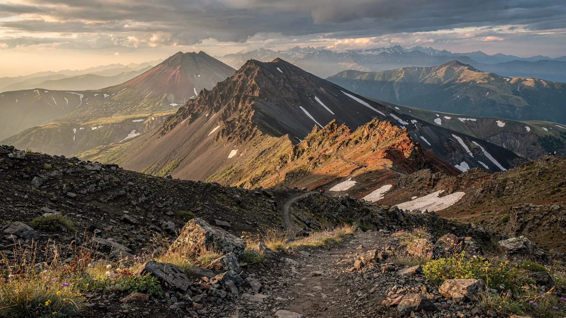
Aragats is Armenia’s most studied volcanic structure. Geologists classify it as a large Quaternary stratovolcano — built up from successive layers of lava flows and pyroclastic deposits over the past 2–3 million years. Unlike a simple cone (think Fuji or Etna), Aragats represents the collapsed remains of a once-higher volcanic edifice: the central caldera is the hole left when the volcano’s summit collapsed inward, either during a massive eruption or through gradual subsidence.
The four peaks — south (3879m), east (3916m), west (4080m), north (4090m) — are remnants of the original caldera rim. Lake Kari at 3200m occupies the caldera floor, its water sourced from snowmelt and precipitation in a closed basin with no surface outflow.
Lava flow evidence: The slopes below Aragats are covered in basalt and andesite lava flows that reached the Araratian plain during past eruptions. Some of the flows are geologically young (in the context of millions of years) — you can see the rough, ropy surface texture of solidified lava on road cuts between Aparan and Byurakan. This is aa lava (rough, blocky texture), compared to the smoother pahoehoe type (ropy texture) found in more fluid flows.
Obsidian: One of the most valuable geological resources in prehistoric Armenia. Obsidian (natural volcanic glass formed from rapidly cooled, silica-rich lava) outcrops on the Aragats flanks and more extensively in the Geghasar area of the Geghama range. Armenian obsidian was traded across the ancient world: outcrops near Lake Van (in modern Turkey, but within the historical Armenian zone) and in the Geghama hills supplied blade-making material to settlements in Mesopotamia, the Levant, and Egypt from at least 12,000 years ago. Obsidian is still collected from the Geghama plateau today.
The Geghama volcanic plateau
Between Lake Sevan and the Araratian plain, the Geghama range presents the most purely volcanic landscape in Armenia. The plateau is a lava field — vast sheets of dark basalt interrupted by scoria cones (smaller subsidiary volcanic vents that look like rough reddish-black heaps), lava tubes, and the larger volcanic edifices of Azhdahak and the Geghasar peaks.
The plateau sits at 2500–3500m altitude, treeless, windswept, and in places lunar in appearance. It is a landscape created by multiple eruption episodes over the Pleistocene and Holocene — some of the flows may be only a few thousand years old in geological terms.
Azhdahak (3597m): The highest point of the Geghama range and one of the finest dormant volcano structures in the South Caucasus. The summit caldera holds a permanent crater lake — arguably the most dramatic single feature of any Armenian mountain. The lake is ice-free from July to October; in winter, it is completely frozen. The Azhdahak volcano hike guide covers the approach and summit in detail.
The petroglyphs: The Bronze Age inhabitants of the Geghama plateau carved rock art onto the volcanic boulders scattered across the landscape. Estimates of the total number of carvings across the range exceed 20,000. The same plateau that produced the obsidian tools and the scoria cones also produced the deer, hunters, and solar symbols carved by people who lived here thousands of years before the Armenian state existed.
Ararat: the volcanic giant across the border
Mount Ararat (5137m) is also volcanic — a large Quaternary stratovolcano, similar in type to Aragats but significantly larger and younger in geological terms. It is not currently erupting but is considered potentially active. The last recorded eruption was in 1840, when a massive landslide and possible eruption destroyed the village of Arguri on the lower slopes and killed hundreds of people.
Ararat sits on Turkish territory and cannot be climbed from the Armenian side — the border has been closed since 1993. But its volcanic nature is visible from the Armenian side: the smooth, symmetrical cone of Great Ararat (5137m) and the adjacent Little Ararat (3896m) are classic stratovolcano forms, built from alternating lava and ash deposits. The snow that covers the upper third of the mountain year-round lies on volcanic rock that was deposited in eruptions over the past 3 million years.
The Mount Ararat from Armenia guide covers the viewing and cultural context. The geological connection between Ararat and Aragats is worth noting: both sit on the same Armenian volcanic highland zone, both are Quaternary stratovolcanoes, and both would have been geologically active during the period when humans first inhabited the Armenian plateau.
How geology shaped Armenian architecture
The volcanic landscape did not just create scenery — it provided the building material for Armenian civilisation. The three main volcanic stones used in Armenian architecture each have distinct visual and physical properties:
Basalt: Dark grey to black, very hard, used for foundations, paving, and decorative elements. The khachkar (cross-stone) tradition uses basalt for some of the finest carved examples.
Andesite: Grey to pinkish, harder than tuff, used for structural elements and columns in church architecture.
Tuff (tuff): Porous, lightweight, easy to carve, and available in shades from pink to rose to yellow-orange. Tuff is the defining material of Armenian architecture — the warm pink-rose colour of Yerevan’s buildings comes from Armenian tuff, mined from the Artik quarries in Shirak province. Etchmiadzin, the ancient capital, Garni temple, Khor Virap, and hundreds of monasteries are all built from this volcanic stone.
The next time you stand in front of an Armenian monastery and notice the intricate carved decoration, remember: that carved stone is solidified volcanic ash. The artisans of the 10th–13th centuries were carving volcano.
Visiting the volcanic landscapes
Aragats caldera and Lake Kari: The most accessible high volcanic landscape in Armenia. The Lake Kari day trip guide covers what to expect and when to go. Open June–October by road.
Geghama plateau and Azhdahak: The most remote and visually dramatic volcanic landscape. Requires 4WD access and good navigation. Best June–September. See the Azhdahak hike guide.
Garni gorge (Symphony of Stones): The most accessible volcanic rock formation near Yerevan. The basalt columns of the Garni gorge were formed by lava cooling in the Azat river valley and then exposed by river erosion — the resulting organ-pipe formations are one of Armenia’s most photographed natural features, 28 km from Yerevan.
Kasakh gorge: Basalt cliffs and volcanic rock formations above the Kasakh river, walkable on the trail between Hovhannavank and Saghmosavank monasteries. The Kasakh gorge trekking guide covers this route.
Khor Virap viewpoint: While not volcanic itself, Khor Virap offers the best view of Ararat’s volcanic form from Armenian territory. The Khor Virap monastery guide covers the visit.
A guided Aragats southern summit day hike places you directly on the volcano’s caldera rim — the most immersive way to experience the geological reality of Armenia’s volcanic landscape.
For the Geghama plateau specifically, the 5-day private hiking and cultural tour from Yerevan can be designed to include the Azhdahak volcanic zone alongside other highland experiences.
Seismic activity and earthquake history
Armenia’s volcanic and tectonic history comes with a darker side. The country is highly seismically active — a result of the same tectonic collision that drove the volcanism. Major earthquakes have shaped Armenian history:
1319: A devastating earthquake destroyed the medieval capital Ani (now in Turkey).
1679: The Garni earthquake killed tens of thousands in the Araratian plain.
1926: Leninakan (now Gyumri) heavily damaged.
1988: The Spitak earthquake (7.0 magnitude) killed between 25,000 and 50,000 people in northern Armenia, levelling Spitak and causing major damage to Gyumri. It remains one of the most destructive earthquakes of the 20th century and fundamentally shaped the modern history of northern Armenia.
The medieval Gavazan Column at Tatev monastery — a 9-metre stele designed to sway with seismic tremors as an early warning system — is a direct acknowledgement of this seismic reality by medieval Armenian builders. See the Tatev monastery complete guide for more on that structure.
Frequently asked questions about Armenia’s volcanic landscapes
Is Mount Aragats still an active volcano?
Aragats is classified as dormant — no eruptions have been recorded in historical time, and the geological evidence suggests the last major volcanic activity was tens of thousands of years ago. However, in geological terms, “dormant” means potentially capable of activity. There are no current indications of renewed activity. The volcano is considered safe for hiking.
Can I collect obsidian from the Geghama plateau?
Collecting obsidian and other geological samples from the Geghama plateau (which lies partly within a protected area) is subject to Armenian heritage and environmental law. Small souvenir pieces of volcanic rock are typically ignored by authorities but commercial collection is prohibited. Check current regulations with the relevant Armenian ministry before collecting anything significant.
Where can I see the best examples of Armenian volcanic tuff architecture?
Yerevan’s characteristic pink-rose city buildings are the most widespread example. For architectural quality, the monasteries of Noravank (red sandstone gorge, partially tuff), Tatev, and Khor Virap are outstanding. The Garni temple is built from dark basalt. Haghpat and Sanahin in Lori use grey-black volcanic stone. The full architectural range covers most of the country’s volcanic stone types.
Is the Garni gorge (Symphony of Stones) related to Aragats volcanism?
Yes. The basalt organ-pipe columns of the Garni gorge were formed from lava flows associated with the broader Armenian plateau volcanism, cooled in the Azat river valley and subsequently exposed by river erosion. They are not directly from Aragats eruptions but from the same general Quaternary volcanic province.
How does Armenian volcanic geology compare to Iceland?
Both countries are highly volcanic; Iceland lies on a mid-ocean ridge with active spreading, while Armenia sits on a continental collision zone. Iceland’s volcanic activity is more frequent and more dramatic (active eruptions, geysers, more recent lava fields). Armenia’s volcanism is older and less frequent but has shaped the landscape more pervasively through the accumulated depth of ancient lava flows and the enormous volcanic edifices like Aragats.
A geological travel itinerary for Armenia
For visitors primarily interested in experiencing Armenia’s volcanic landscapes, the following circuit creates a coherent geological journey from Yerevan:
Day 1 — Yerevan and the pink tuff city: Yerevan’s architecture is the first expression of Armenian volcanic geology. The characteristic pink-rose colour of the buildings (particularly visible at Republic Square and the Cascade) comes from Armenian tuff, a compressed volcanic ash stone. Walk the city and see the building material in context. Evening: visit the Erebuni fortress — the 2800-year-old Urartian citadel is built from the same basalt blocks you will see throughout the trip.
Day 2 — Garni gorge and basalt columns: The Garni gorge (Symphony of Stones) offers the most accessible volcanic rock formation in the country. The basalt organ-pipe columns are 40 minutes from Yerevan, combined naturally with Garni temple (basalt) and Geghard monastery (carved directly into the volcanic cliff face). This is a half-day that puts you inside Armenian volcanic geology in its most photogenic form.
Day 3 — Kasakh gorge and Aragats approach: Drive north on the M3. The Kasakh gorge trail between Hovhannavank and Saghmosavank crosses the top of basalt flows that poured from the Aragats massif. Continue to Amberd fortress (basalt and tuff construction at 2300m). End the day at Lake Kari if the road is open.
Day 4 — Aragats caldera: Full day on the volcano. Hike the southern summit or simply spend the day at the caldera level, walking the rim and studying the geological formations. The volcanic texture of the summit rocks — basalt, andesite, scoria — is directly accessible without special knowledge.
Day 5 — Geghama plateau and Azhdahak: Drive east to the Geghama volcanic range. Explore the petroglyph boulders on the lower plateau, then summit Azhdahak (3597m) for the crater lake experience. Return via Lake Sevan (formed in a tectonic basin between the Geghama and Vardenis volcanic ranges).
This five-day circuit covers every major volcanic landscape type in Armenia — from columnar basalt to volcanic tuff architecture, from active caldera remnants to crater lakes, from obsidian outcrops to Bronze Age petroglyph fields — while connecting all the major cultural and natural highlights of the country.
Reading the rock: a field guide to Armenian volcanic stones
Dark grey basalt: The most abundant rock in the Armenian landscape. Hard, heavy, slow to weather. Used for road stone, monastery foundations, khachkars. The Kasakh gorge walls and the Garni gorge columns are basalt. Feels slightly rough to the touch; rings when struck with metal.
Pink-rose tuff: Compressed volcanic ash, cut into blocks for building. Light, easy to carve, excellent insulation. Yerevan’s defining material. Artik quarries in Shirak produce the finest quality. The warm colour varies from pale salmon to deep rose depending on iron content.
Andesite: Grey to pinkish volcanic rock, harder than tuff but less dense than basalt. Used for column capitals, carved decoration on church interiors. The relief carvings on Amberd church exterior are andesite.
Obsidian: Black volcanic glass, razor-sharp when knapped. Found at Geghama and Geghasar range outcrops. Looks like black glass; conchoidal (shell-like) fracture pattern when broken. The most traded Armenian geological material in prehistory.
Scoria: Red-brown porous volcanic rock, formed from gas-rich lava flows. Lighter than basalt, very porous. Appears as reddish-brown heaps on the Geghama plateau. Not used in building but visually distinctive as small scoria cones marking subsidiary volcanic vents.
Connecting the volcanic landscapes to Armenian spiritual geography
The volcanically-formed gorges, cliffs, and caves of Armenia did not merely provide building material — they shaped the architecture of religious experience. The cave springs at Geghard (whose name means “spear” in Armenian, referring to the Holy Lance of Longinus, but whose site has religious significance far older than Christianity) represent a pre-Christian reverence for the underground world of the volcano — the place where water emerges mysteriously from rock, where the earth is open, where the boundary between surface and depth dissolves.
The massive basalt promontory of Tatev is not just a convenient hilltop — it is a geological statement, a column of rock so dramatic that its occupation by a monastery seems architecturally inevitable. Noravank’s red limestone cliffs (not volcanic — Devonian limestone, geologically distinct) perform the same function: the cliff framing the monastery entrance is the cliff doing the theology.
Understanding the volcanic geology of Armenia means understanding the conditions that created this particular form of sacred landscape — not decorative, not incidental, but foundational to why Armenian religious heritage looks the way it does and sits where it sits.