Azhdahak volcano: petroglyphs and summit hike
A dormant volcano with a Bronze Age past
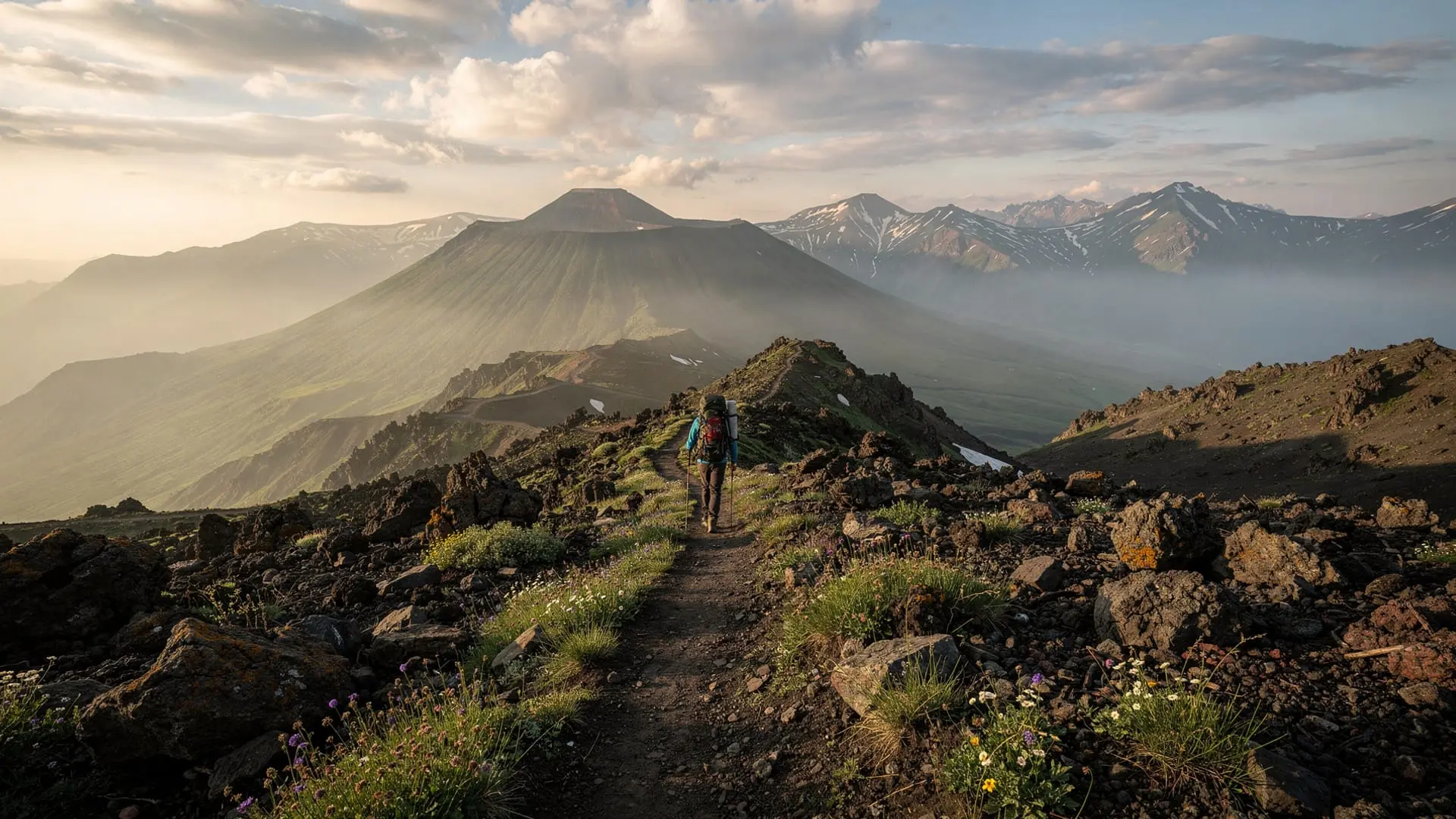
Mount Azhdahak (3597m) is the highest point of the Geghama volcanic range, a massif of extinct craters, obsidian fields, and open alpine plateaux that sprawls across central Armenia between Lake Sevan to the east and the Araratian plain to the west. The name Azhdahak means “dragon” in Armenian, from an ancient mythological king. The mountain is a dormant stratovolcano and its summit holds one of the most dramatic features in Armenian highland geography: a permanent crater lake, roughly 150m in diameter, that occupies the caldera and remains ice-covered until late June in most years.
What makes Azhdahak exceptional among Armenian hiking destinations is the combination of natural grandeur and deep prehistory. The basalt boulders scattered across the Geghama plateau are among the richest outdoor galleries of Bronze Age rock art in the entire Caucasus. Herders, hunters, and ritual specialists of the Early and Middle Bronze Age carved thousands of images into these dark volcanic surfaces — images that remain shockingly clear despite three to five thousand years of exposure to the alpine elements.
The petroglyphs: what you will see
The Geghama petroglyph fields were first documented by Soviet archaeologists in the 1960s and have been studied intensively since Armenian independence. Estimates of the total number of carvings range from 10,000 to over 20,000 across the full Geghama range.
On the Azhdahak approach, carvings appear from around 2600m altitude. The most common images are:
Animals: Red deer (with elaborate antlers, sometimes portrayed mid-leap), wild goat and ibex, aurochs (wild cattle, now extinct), horses, wolves, and composite creatures that may be mythological. The deer carvings are the most numerous and have become emblematic of Armenian Bronze Age art.
Hunting scenes: Figures on foot or horseback pursuing prey, sometimes with what appear to be bows. These scenes give a direct window into Geghama hunting culture of 2000–1500 BC.
Geometric and solar motifs: Circles, spirals, rosettes, and dot-and-circle patterns. Their ritual or calendrical significance is debated.
Human figures: Rarer than animals, but present — sometimes in processions, sometimes in postures that suggest ritual activity.
Most carvings are on horizontal or gently angled boulders, not vertical cliff faces. This means you walk among them rather than looking up at them — an intimate encounter. The stone is dark grey-black basalt; the carved surfaces have oxidised to a slightly lighter grey over millennia, making many images clearly legible.
Important: carvings are fragile and irreplaceable. Do not touch, chalk, or rub the petroglyphs. Lighting conditions matter enormously — morning or late afternoon side-light brings carvings into relief; direct noon sun flattens them. Early morning hikers see the petroglyphs at their best.
Hiking route to the summit
Approach: The most common starting point for Azhdahak is from the village of Geghadir or from a high track accessible by 4WD, cutting the approach from roughly 2600m altitude. The road to the Geghama plateau is unpaved and requires a high-clearance vehicle for the upper section.
From Geghadir village:
- Starting altitude: ~1700m
- Summit altitude: 3597m
- Elevation gain: ~1900m
- Distance: 18–20 km round trip
- Time: 8–10h
- Difficulty: Hard
From upper 4WD access point (~2600m):
- Elevation gain: ~1000m
- Distance: 10–12 km round trip
- Time: 5–6h
- Difficulty: Moderate-hard
From the 4WD starting point, the route crosses open plateau — rolling volcanic terrain with scattered basalt boulders, many bearing petroglyphs. The first section is an easy walk. From around 3200m the gradient steepens as the volcanic cone proper begins. The upper section is loose volcanic scree (similar to but steeper than the Aragats south peak approach). The crater rim is reached before the true summit; the lake appears suddenly and dramatically below.
The summit cross stands at the highest point of the crater rim. Views encompass Lake Sevan to the east, Aragats to the west, and the Araratian plain to the south.
The crater lake
The crater lake is one of the most surprising features of any Armenian mountain. The caldera that holds it is several hundred metres across, and the lake occupies its deepest section. In late June it is still largely ice-covered; by late July it is fully open water, reflecting the sky with extraordinary clarity at this altitude. The lake has no outflow — it is fed entirely by snowmelt and precipitation.
Swimming in the lake is theoretically possible in August (brave souls have done it) but the water temperature rarely exceeds 10°C. More practically, the crater rim makes a fine lunch stop with one of the most unusual views in Armenia.
Getting there from Yerevan
Azhdahak is not as well-served by public transport as Aragats. The most practical approach is a rented car or a guided 4WD tour. From Yerevan, take the M1 highway toward Lake Sevan, then turn south on the road toward Geghadir via Gavarr. The upper Geghama track branches from the main road and requires 4WD capability; do not attempt it in a standard car.
From Yerevan the drive to the 4WD starting point takes about 2–2.5 hours.
Alternatively, the Geghama plateau is accessible from the Tsaghkadzor side (via Kotayk province), though the western approach involves more unpaved distance.
Guided hike options
A guided Mount Aragats day hike from Yerevan can serve as excellent acclimatisation preparation before attempting Azhdahak — the two mountains share similar altitude profiles and terrain character, and many guides who lead Aragats tours also operate Geghama plateau excursions.
For a multi-day hiking experience combining the Geghama petroglyphs with broader Armenian highland trekking, the 5-day private hiking and cultural tour from Yerevan offers the combination of landscape, altitude, and cultural depth that Azhdahak fits into naturally.
What to bring and preparation notes
At 3597m, Azhdahak requires the same high-altitude preparation as Aragats. The full Armenia trekking gear checklist applies. Azhdahak-specific considerations:
- Navigation: the plateau has no formal trail marking. A downloaded GPS track (available on Wikiloc under “Azhdahak”) is essential. The terrain looks similar in all directions in mist.
- Weather: the Geghama plateau is exposed and weather changes fast. Afternoon storms are common in July–August. Start before 7am.
- Water: no guaranteed water source above the villages. Carry 3 litres.
- Photography: a lens cloth for dust, and a polarising filter to cut the high-altitude glare.
Connecting Azhdahak to other Armenia sites
The Geghama range’s position between Lake Sevan and the Araratian plain places Azhdahak within a comfortable combined itinerary. A three-day loop from Yerevan might cover: Aragats (south summit) on day 1, Lake Sevan shoreline on day 2, and Azhdahak from the eastern Geghama approach on day 3.
For broader highland context, the Mount Aragats four-peaks guide and the When to hike in Armenia guide both provide comparative context for planning an ambitious Armenian mountain trip.
The Armenia volcanic landscapes guide covers the geological setting of Azhdahak within the broader picture of Armenian volcanism — useful background reading before a visit.
Frequently asked questions about the Azhdahak hike
Is it possible to see the petroglyphs without hiking to the summit?
Yes. The lower plateau between 2600m and 3000m altitude — accessible from the 4WD track — contains significant petroglyph concentrations. A half-day circuit of the plateau boulders without summiting is entirely feasible and appropriate for less fit visitors or those specifically interested in the rock art rather than the summit.
When are the petroglyphs most visible?
In low-angle morning or evening light, the carved lines on the basalt boulders cast shadows that make them much clearer than in flat midday light. Arrive early (6–7am at the plateau) for the best petroglyph photography. After September, lower sun angles throughout the day improve visibility.
How remote is the Geghama plateau?
Very remote by Armenian hiking standards. There are no facilities above the villages, no established guesthouses on the plateau, and no mobile signal for much of the route. This is a serious mountain day that requires preparation. Do not attempt it solo without GPS, experience, and emergency communication.
Can I combine Azhdahak with Aragats in the same trip?
The two mountains are on opposite sides of the Araratian plain — Aragats to the north-west, Azhdahak to the south-east. A day each is the standard approach, making a 2-day Yerevan-based trip feasible: Aragats on day 1 (with Lake Kari as the base), Lake Sevan on the evening of day 1, Azhdahak from the eastern approach on day 2.
Are there any safety concerns specific to Azhdahak?
Navigation in poor visibility is the primary risk on the open Geghama plateau — GPS is mandatory. Lightning strikes are possible on the exposed summit during afternoon storms. The crater rim is a steep drop on the inner side — keep children and inexperienced hikers away from the edge.
The Geghama people: Bronze Age highland life
Standing on the Geghama plateau beside a basalt boulder covered in deer carvings, it is worth spending a moment with the people who made these images. We do not know their name — they predate the Armenian ethnic identity by over a thousand years. What we know from archaeology is that they were herders and hunters, probably semi-nomadic, spending the highland summer months on these pastures as their descendants did until the 20th century.
The animals they carved tell us what they saw: herds of red deer and ibex, the aurochs (wild cattle, extinct now but common in the Bronze Age Caucasus), horses that may or may not have been domestic at this period, and occasional figures of wolves and composite creatures that probably had ritual significance. The solar circles and geometric patterns are harder to interpret but appear across Bronze Age cultures from Europe to Central Asia — evidence of a shared symbolic vocabulary spread by the movement of people and ideas along the mountain corridors.
The obsidian from the Geghama plateau was one of the most valuable trade commodities in the ancient world. Blocks of volcanic glass from sources we can now fingerprint chemically — because each obsidian source has a unique chemical signature — have been found at archaeological sites in Turkey, Iraq, Syria, and even Egypt. The people who made the petroglyphs on Azhdahak’s slopes were also the people who controlled this trade in volcanic glass.
When you pick up a piece of obsidian on the plateau — a piece with the distinctive conchoidal fracture of volcanic glass and the jet-black translucency — you are holding something that might once have been a knife blade traded from here to Mesopotamia 7,000 years ago.
The Geghasar highlands: Azhdahak’s neighbours
Azhdahak is the highest point of the Geghama range but not the only volcanic summit worth noting. The broader highland area known as the Geghasar (from the Armenian for “blue mountain”) contains several other prominent peaks and associated petroglyph sites:
Spitakasar (“white mountain”): A caldera peak at 3560m north-west of Azhdahak with its own petroglyph concentration. The name refers to the light-coloured volcanic rock of the summit area, distinct from the darker basalt of Azhdahak.
Geghasar proper: The ridge that gives its name to the highland zone, running north of Azhdahak toward Lake Sevan. Several obsidian outcrops on this ridge have been archaeologically studied.
For hikers with 2+ days in the Geghama zone, combining Azhdahak with an exploration of the broader petroglyph distribution across multiple adjacent summits turns a single-peak day hike into a multi-day archaeological and geological exploration. No established multi-day route exists for this circuit — it requires GPS navigation and self-sufficient camping — but the rewards for serious hikers are substantial.
Getting the most from the petroglyphs
Photography of Bronze Age rock art requires specific technique. The carvings are incised into dark basalt and appear as lines approximately 1–3cm wide and 0.5–1cm deep. In flat midday light they are almost invisible; in raking side-light they are dramatic.
Best conditions: Early morning on an east-facing boulder (first light rakes the surface from the east); late afternoon on a west-facing boulder. Cloudy bright (overcast without direct sun) creates even side illumination across all boulder faces.
Practical: Carry a small LED torch or headlamp to artificially illuminate carvings when natural light is suboptimal. This technique (raking the torch beam at low angle across the rock surface) dramatically reveals carving depth and detail.
Documentation: If you photograph a carving that appears to be previously undocumented or different from the Wikiloc/AllTrails records you checked before the hike, report it to the Institute of Archaeology and Ethnography in Yerevan. New petroglyphs are still being identified on the Geghama plateau.
Logistics for a two-day Geghama expedition
For hikers who want to cover both the Azhdahak summit and a thorough petroglyph survey, a two-day approach from a Yerevan base works well:
Day 1: Drive from Yerevan to the Geghama upper 4WD access point (2.5h). Afternoon: explore the lower plateau petroglyph zone (2600–3000m) without summiting — the most concentrated carvings are in this band. Camp at the 4WD access point.
Day 2: Early start (6am). Summit Azhdahak and explore the crater rim and lake (5–6h). Descend and drive back to Yerevan.
This pacing allows time to properly study the petroglyphs rather than rushing past them on the way to the summit. Bring a camp stove — evenings at 2600m are cold even in August, and a hot meal significantly improves the experience.