Bjni to Tsaghkadzor: forest traverse hike
A forest crossing hiding in Kotayk province
The hike from Bjni village to Tsaghkadzor is one of the most satisfying forest walks near Yerevan — a genuine point-to-point traverse through some of the densest beech and oak woodland in Kotayk province. It connects two very different places: Bjni is a small village with a medieval fortress on a river bluff, quietly crumbling into the surrounding hillside; Tsaghkadzor is a modern ski resort town with cable cars and après-ski restaurants. The 12–15 km trail between them crosses a forested ridge that belongs to neither world — an elevated quiet that makes the hike feel longer and more remote than the map distance suggests.
This route is a strong contender for the best half-day or moderate full-day hike within 60 km of Yerevan. It lacks the drama of an Aragats summit or the UNESCO heritage of Dilijan, but it delivers something else: a genuine mountain forest experience without the logistics of reaching the deep north or south of Armenia.
Bjni village and fortress
Bjni sits in the Hrazdan river valley in Kotayk province, about 35 km from Yerevan. The village is known primarily for its medieval fortress — a 10th–11th century structure perched on a basalt spur above the river, partially collapsed but still impressive in its surviving elements. The fortress was a seat of the Pahlavid dynasty and controlled the trade route through the Hrazdan valley below.
Most visitors drive through Bjni on the way to Tsaghkadzor without stopping. Those who do stop typically park near the fortress, spend 30–45 minutes exploring the ruins, and then continue by car. The hikers’ approach turns Bjni into a starting point rather than a sideshow — and the fortress is the perfect psychological departure point for a day in the mountains.
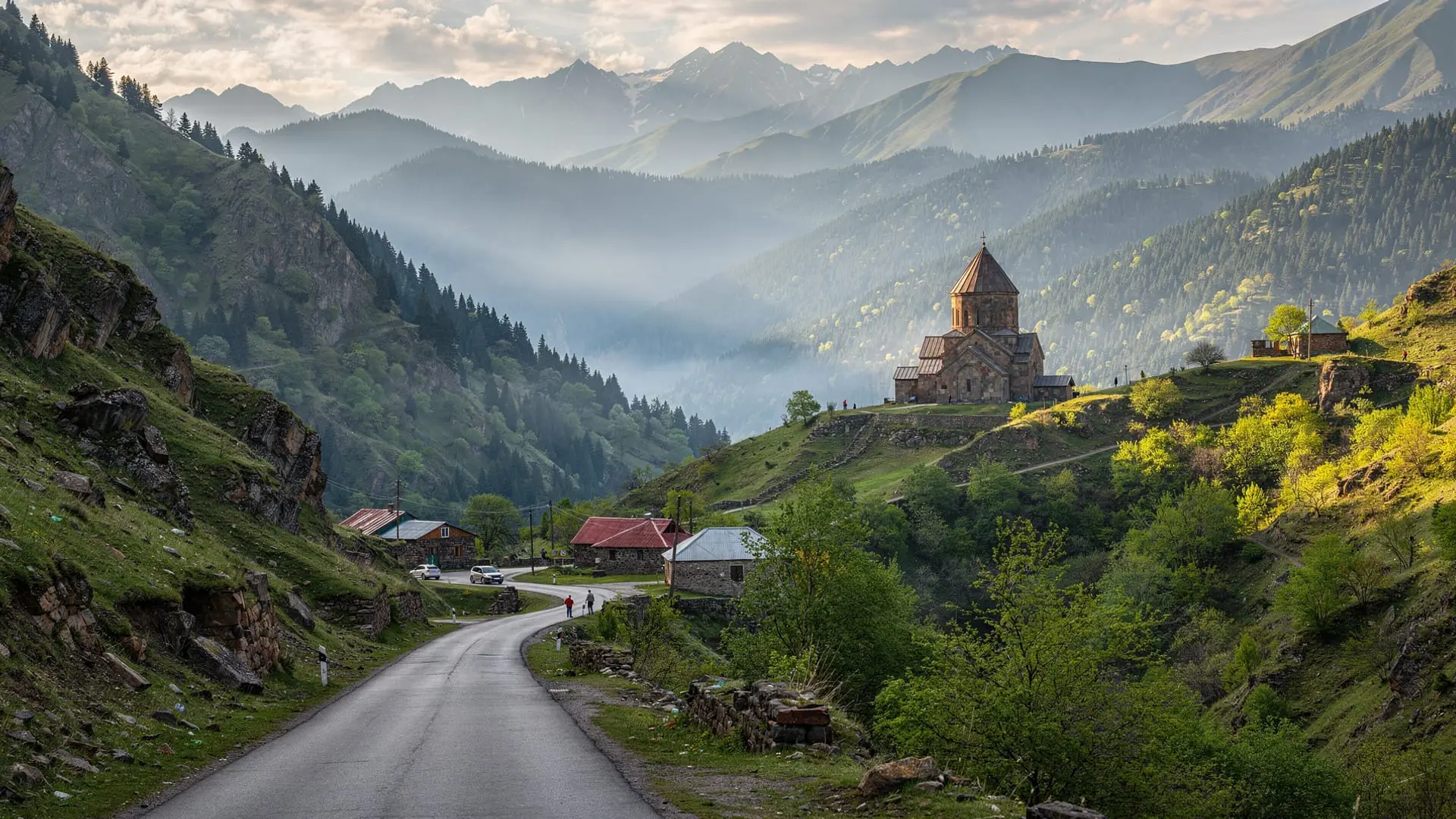
Route description
Start: Bjni village, fortress car park (~1100m)
End: Tsaghkadzor town centre or ski resort lower station (~1850m)
Distance: 12–15 km (varies by exact route taken)
Elevation gain: ~900m to ridge, then descent ~200m to Tsaghkadzor
Time: 5h one-way
Difficulty: Moderate
From the Bjni fortress car park, take the forest track that climbs north-east into the beech woodland. The path is clear for the first 3–4 km — wide enough for forestry vehicles, with good shade. The forest here is mixed beech and oak with an understorey of wild rose, hawthorn, and in spring, wild peonies and wood anemones.
From around 1400m, the gradient increases and the track narrows to a hiking path. At approximately 1600m you cross the main ridge — the first point on the hike where views open up significantly. To the north, the Tsaghkadzor valley and the Marmarik range are visible; behind you (south) the Araratian plain stretches to the Turkish border on clear days.
The descent from the ridge into Tsaghkadzor follows a series of forest paths and occasional ski run edges. The forest on this western side of the ridge is lusher — more moisture from north-facing slopes, taller beeches, and in September, a sea of mushrooms (porcini, chanterelles, and numerous Caucasian species).
The trail emerges near the Tsaghkadzor cable car lower station, from where the town centre is a 10-minute walk.
The Janapar Trail connection
This traverse follows a section of the Janapar Trail — the yellow-blazed long-distance route that predates the Transcaucasian Trail. Hikers with an eye for trail markers will spot the yellow triangles and dots painted on trees along the ridge section. The Janapar Trail guide has more detail on the full route context; for the Bjni-Tsaghkadzor section, the Janapar markings are among the better-maintained on the entire route.
Getting there and back
Bjni (start): From Yerevan, take the M1 road toward Lake Sevan, turning off toward Bjni after about 30 km. The drive takes 35–40 minutes. No direct marshrutka runs to Bjni — take a marshrutka toward Hrazdan from Yerevan’s Kilikia station and ask to be dropped at the Bjni junction (about 45 min), then a short taxi or on-foot approach to the village.
Tsaghkadzor (end): Marshrutkas from Tsaghkadzor to Yerevan run via Hrazdan. From the resort town, finding transport back to Yerevan in afternoon hours is generally straightforward. A taxi from Tsaghkadzor to Yerevan costs about 5,000–7,000 AMD.
Shuttle logistics: For a point-to-point hike, the cleanest option is one car at each end — drive one car to Tsaghkadzor, taxi to Bjni, hike back to Tsaghkadzor. Alternatively, hire a driver who will drop you at Bjni and collect you in Tsaghkadzor at an agreed time.
Organised hike: The guided Bjni to Tsaghkadzor trek from Yerevan handles all transport logistics, provides a guide for the forest sections, and includes return to Yerevan — making it the easiest option for visitors without a car or local knowledge.
Tsaghkadzor as a base for hikers
Tsaghkadzor is primarily known as Armenia’s only ski resort — a Soviet-era station that has been substantially upgraded since independence and now offers 27 km of runs and a modern gondola system. But in summer and autumn, the resort town transforms into a hiking base with comfortable accommodation, good restaurants, and empty trails on the surrounding hills.
The cable car operates year-round (not just in ski season) and can be used to shortcut the final ascent to the ridge — useful if you want to hike the Bjni approach and then use the cable car to access higher terrain above Tsaghkadzor.
Accommodation: Tsaghkadzor has a wide range from budget guesthouses to the Hotel Armenia (large Soviet sanatorium, eccentric but affordable) and several boutique options. Prices are significantly lower outside ski season (late April–November).
Combining with Bjni fortress and other Kotayk sites
A full Kotayk day might look like this: Bjni fortress (45 min) → forest traverse to Tsaghkadzor (5h) → cable car to upper station (30 min) → lunch in Tsaghkadzor → afternoon drive to Garni temple (45 min from Tsaghkadzor via Hrazdan) → return to Yerevan via Geghard. This is an ambitious day but one that covers an extraordinary density of Kotayk highlights.
Shorter alternatives: combine the Bjni–Tsaghkadzor traverse with an afternoon at the Tsaghkadzor–Sevan day combo for a two-destination Kotayk experience.
Season and conditions
April–June: The forest is at its most green and flowery. Wildflowers peak in May. The trail is muddy in early April after snowmelt but generally hikeable from mid-April.
July–August: Warm and pleasant in the forest, which provides shade. The mushroom season begins in late August. Well-maintained trail conditions.
September–October: The best month. Beech forest turns golden-orange in late September — this traverse is one of the finest autumn colour walks in Kotayk province. Clear views from the ridge. Highly recommended.
November–March: Snow on the ridge section from November. Ski season at Tsaghkadzor from December. The traverse is not recommended in winter without proper snow gear.
Gear and practical notes
No specialist equipment needed. Sturdy hiking shoes (the descent into Tsaghkadzor can be muddy), a rain layer (even in summer, Kotayk forest creates moisture), trekking poles for the steep descent, and 1.5–2 litres water (no stream crossings on the ridge section).
Full kit recommendations in the Armenia trekking gear checklist. For mushroom foragers visiting in September, local hikers and guides can point out which species are edible — Caucasian porcini (locally called “boletus”) are the most prized and concentrated on the beech-dominated ridge.
Frequently asked questions about the Bjni–Tsaghkadzor hike
How difficult is the Bjni–Tsaghkadzor traverse compared to other Armenian hikes?
It is a moderate hike suitable for fit beginners. The elevation gain is significant (900m to the ridge) but spread over 6–7 km, making it gradual rather than brutal. The terrain is mostly forest path — no exposed ridges or technical sections. A reasonable comparison: slightly harder than the Lake Parz loop in Dilijan, considerably easier than the Aragats southern summit.
Is there a trail map available?
No official printed map exists for this specific route. Download a GPX track from Wikiloc (“Bjni Tsaghkadzor”) before leaving Yerevan. The maps.me Armenia offline map also shows the main track. The Janapar yellow blazes provide navigation aid on the ridge section but are not consistently present in the lower forest.
What wildlife might I see on the hike?
The Kotayk beech forest is good for woodpeckers (great spotted, middle spotted), Caucasian jay, and in the open ridge section, common buzzard and kestrel overhead. Red deer are present but rarely seen during the day. Wild boar signs (rooted earth) are common in the lower forest.
Can children do the Bjni–Tsaghkadzor traverse?
Children aged 10+ with reasonable fitness can complete the hike. The gradient is sustained but not extreme. The forest provides shade and interest for younger hikers. Allow more time than the standard 5 hours and bring plenty of snacks.
Is Bjni fortress worth the detour?
Yes, especially if you are already coming to start the hike. The fortress is not one of Armenia’s best-preserved medieval sites — significant sections have collapsed — but the setting above the Hrazdan river gorge is atmospheric, and the historical context (a Pahlavid-era stronghold controlling a key valley route) adds depth to the start of the day.
Tsaghkadzor as a hiking base
Beyond the cable car and ski runs, Tsaghkadzor makes a genuine hiking base for the Kotayk highlands. The resort town sits at 1850m, higher than almost any other Armenian town, which means you start each hike already acclimatised to moderate altitude. The surrounding hills are crossed by forest tracks and unmarked paths that experienced hikers can explore with a good GPS map.
Beyond the traverse: From the cable car upper station (2800m), additional hiking options open up:
- A ridge walk north along the Tsaghkadzor massif to Marmarik peak (3½ h round trip) gives views across Kotayk and into Gegharkunik
- The cable car descent followed by a forest walk back to the town through the lower piste area (1½ h) is an easy afternoon option
Accommodation in Tsaghkadzor: The resort has a wide range from budget guesthouses to the large Hotel Armenia (Soviet sanatorium, characterful if not luxurious) and several smaller boutique-style options. Prices in summer are 30–60% lower than ski season rates. The Hin Bjni guesthouse, named after the original village, operates near the cable car station and caters specifically to hikers.
Eating: Several restaurants operate year-round near the cable car station. Armenian staples (khorovats, tolma, manti) dominate menus. The resort’s small supermarket stocks trail food basics.
Bjni village in detail
Bjni’s medieval fortress is the defining feature but the village itself has a quiet charm worth a brief exploration before starting the hike. The village is home to a mineral water spring — Bjni mineral water is one of Armenia’s most widely sold brands and the source spring is here. A small bottling facility operates nearby. The water itself, with its distinctive slight mineralisation, is a pleasant companion for the gorge walk upstream.
The fortress stands on a promontory of dark basalt above the Hrazdan river. The surviving walls enclose an area that included residential buildings, a church (now reduced to foundations), and storage facilities. The Pahlavid lords who built and occupied Bjni were a family with deep roots in Armenian noble culture — the same dynasty that built Amberd fortress on the Aragats slopes.
The view from the fortress ruin north-east toward the Kotayk highlands previews exactly the terrain you will walk through on the traverse: forested ridges rising from the valley, the Hrazdan river glinting in the gorge below, and in clear conditions the distant white cap of Aragats above the western horizon.
Autumn colour on the traverse
The Bjni–Tsaghkadzor forest in September–October is one of the finest autumn colour walks in the entire Armenian highlands. The dominant species on this section are Oriental beech (copper-bronze from late September), hornbeam (yellow-green), wild cherry (orange-red), and English oak (tawny brown). The combination of species creates a multi-tonal autumn display that peaks in the last week of September and first week of October.
Light in the beech forest at this season — raking morning sun through orange-copper leaves, with green understorey ferns still holding colour below — is extraordinary for photography. A wide-angle lens for the canopy, a longer lens for the autumn detail on individual leaves and berries. The mushroom season (porcini particularly) coincides with the colour peak, making late September the single best week for this hike.
Connecting to the broader Kotayk hiking picture
The Bjni–Tsaghkadzor traverse sits within a cluster of Kotayk hiking options. The Armenia hiking best season guide covers when to hike all the Kotayk routes. For a Kotayk-specific multi-day itinerary:
Day 1: Bjni fortress (morning) + forest traverse to Tsaghkadzor (afternoon)
Day 2: Tsaghkadzor cable car + Kotayk ridge walk (morning) + drive to Garni (afternoon)
Day 3: Garni gorge (Symphony of Stones) + Geghard monastery (morning) + return to Yerevan
This three-day circuit covers the best of Kotayk’s hiking and cultural heritage within a compact geography. All sites are within 70 km of Yerevan, making day transport practical and flexible.