The Caucasus in Armenia: an overview
Where exactly do Armenia’s mountains fit?
The word “Caucasus” is used loosely and often confusingly in travel writing. Understanding the distinction between the Greater and Lesser Caucasus helps make sense of Armenia’s geography and of what to expect when you arrive.
The Greater Caucasus is the main mountain chain — a 1200 km ridge running south-east from the Black Sea coast to the Caspian, forming the geological boundary between Europe and Asia. This is the range associated with Georgia and Russia: the glaciated peaks of Kazbek (5047m), Shkhara (5068m), and Elbrus (5642m, just north of the Georgian border in Russia). These are among the highest mountains in Europe, with permanent glaciers and the dramatic alpine scenery that draws mountaineers worldwide.
The Lesser Caucasus is a separate range running parallel to the Greater Caucasus, 200–300 km to the south. It extends through southern Georgia, northern Armenia, and western Azerbaijan. Armenia’s mountains are part of the Lesser Caucasus. They are lower (maximum 4090m at Aragats), more volcanic in origin, and lack the permanent glaciers of the Greater Caucasus. They are, however, geologically ancient, visually dramatic, and remarkably diverse.
Armenia: 90% mountain country
Over 90% of Armenia’s territory lies above 1000m altitude — a proportion matched by few countries on Earth. The average elevation of the country is approximately 1800m. The lowest point (on the Debed river in Lori province) is 400m; the highest is Aragats north at 4090m.
This extraordinary altitude creates several defining characteristics of Armenian life:
- A dry, continental climate with cold winters and warm summers (dramatically different from coastal Caucasus regions)
- The predominance of highland agriculture: wheat, barley, apricots, grapes — crops adapted to short summers and thin air
- A cultural relationship with mountains that permeates religion, mythology, and national identity
- The volcanic soil that underlies much of Armenia’s characteristic tuff stone architecture
The main mountain ranges
Aragats massif (Aragatsotn province)
The dominant mountain in the western part of the country, Aragats is a collapsed stratovolcano with four peaks (south 3879m, east 3916m, west 4080m, north 4090m). It is both Armenia’s highest mountain and the easiest high-altitude objective, thanks to the road that climbs to Lake Kari at 3200m. The Mount Aragats four-peaks guide covers the hiking options.
The Aragats massif is geologically young (volcanically active relatively recently in geological time) and the surrounding landscape preserves extraordinary evidence of volcanic activity: lava flows, scoria fields, and the caldera lake at the summit.
Geghama range (central)
The Geghama volcanic range extends across the centre of Armenia, forming the watershed between the Araratian plain to the west and Lake Sevan to the east. The highest point is Azhdahak (3597m), a dormant volcano with a summit crater lake. The Geghama plateau is one of the most significant Bronze Age sites in the Caucasus — tens of thousands of petroglyphs carved into the volcanic boulders between 3000 and 1000 BC.
The Azhdahak volcano hike guide covers this range in detail. The Armenia volcanic landscapes guide provides the geological context.
Zangezur range (Syunik province)
In the deep south of Armenia, the Zangezur range connects the Lesser Caucasus to the smaller ranges of the Iranian border zone. Peaks exceed 3000m throughout. The range includes some of Armenia’s wildest terrain — the Syunik section of the Transcaucasian Trail crosses these highlands. Mount Khustup (3201m), above Kapan, is the most significant hiking objective in the range.
The Zangezur corridor has been geopolitically significant throughout Armenian history — it is the territory that links the Armenian highlands to the south and whose preservation within Soviet Armenia (negotiated in part by Garegin Nzhdeh’s last stand in 1921) allowed Armenia to maintain its current southern form.
Vardenis range (Gegharkunik province)
East of Lake Sevan, the Vardenis range rises to 3520m at Mount Vardenis and forms the eastern rim of the Lake Sevan basin. Less visited than Aragats or the Geghama range, the Vardenis highlands are explored mainly by TCT hikers and dedicated wildlife observers.
Pambak range (Lori province)
The Pambak range runs through northern Armenia, contributing to the highland terrain that shelters the Debed river canyon — home to Haghpat and Sanahin monasteries. The range reaches approximately 2900m and its slopes are covered in the mixed broadleaf forests that give Lori its characteristic green character.
Volcanic origins
Armenia’s mountain character is fundamentally volcanic. The Lesser Caucasus fold-mountain system has been overlaid and modified by extensive volcanic activity over the past 5 million years. The result is a landscape of basalt plateaux, obsidian fields (natural volcanic glass, traded across the ancient Near East from Armenian sources for tens of thousands of years), scoria cones, and the great stratovolcanoes of Aragats and Ararat.
Ararat — which sits across the closed border in Turkey but visually dominates the Armenian plain — is also volcanic in origin and is classed as a dormant stratovolcano. The Armenia volcanic landscapes guide explores this volcanic geology in full.
The Araratian plain
The central lowland of Armenia — the Araratian plain, watered by the Araks and Hrazdan rivers — sits at 800–900m and is the agricultural and cultural heartland of the country. Yerevan occupies the northern edge of this plain. The plain is surrounded on all sides by mountains: Aragats to the north-west, Aragats foothills to the north, Geghama range to the east, and — most dramatically — Ararat itself to the south across the Turkish border.
Mountain culture in Armenia
Armenia’s mountain geography has shaped its culture profoundly. The highland pastures above 2000m have supported transhumance — seasonal movement of shepherds and flocks — since prehistory. The Geghama petroglyphs record this herding culture in rock art stretching back to the Early Bronze Age.
The ancient Armenian religion (before Christianisation in 301 AD) was centred on mountain worship — the pantheon included mountain deities, and high peaks were sacred sites. Christianity absorbed some of this mountain reverence: the most important monasteries in Armenia are often perched on mountain ridges or in dramatic gorges, as if continuing a pre-Christian tradition of highland sanctity.
The modern Armenian relationship with mountains blends national pride (Aragats as Armenia’s mountain, Ararat as the unattainable symbolic peak) with a genuine outdoor culture. Yerevan families routinely make day trips to Aragats, Dilijan, and Sevan. Armenian hiking clubs are active, and the TCT/Janapar trail development represents a significant investment in mountain trail culture.
Hiking the Armenian mountain ranges
Each range offers distinct hiking experiences:
- Aragats: accessible, high-altitude summit objectives. Start with the southern summit guide or the Lake Kari day trip.
- Geghama: remote, volcanic, Bronze Age petroglyphs. The Azhdahak guide is the entry point.
- Zangezur / Syunik: wild, serious. The Khustup trek from Kapan is the primary objective.
- Dilijan / Tavush forests: accessible, cultural, forest hiking. The Dilijan National Park hikes guide covers this.
The Aragats northern summit guided tour provides the most complete high-altitude Armenia mountain experience — reaching the country’s highest point with expert guidance.
For a multi-range Armenia mountain itinerary, the 5-day private hiking and cultural tour from Yerevan covers multiple mountain zones in a single structured trip.
Climate across the mountain ranges
Armenia’s mountain climate is broadly continental: cold, snowy winters; warm to hot summers; spring and autumn with dramatic weather transitions. But there are significant local variations:
- Tavush and Lori forests: more moisture from the Black Sea influence, milder winters, greener and more humid than the rest of Armenia
- Geghama plateau: more arid, strongly continental, temperature extremes greater
- Syunik / Zangezur: drier, sunnier, with warm valley floors and cold high terrain
- Aragatsotn / Aragats: dry continental, rapid afternoon weather development in summer
The When to hike in Armenia guide covers the seasonal implications in full.
Frequently asked questions about the Caucasus in Armenia
How high are Armenian mountains compared to the Alps?
Armenia’s highest peak, Aragats north (4090m), is lower than Mont Blanc (4808m) and most major Alpine peaks. However, Armenian mountains rise from lower valley floors — the impression of height and remoteness can be more dramatic than the raw numbers suggest. Unlike the Alps, Armenian highlands have no ski infrastructure above 2000m and far less trail maintenance.
Are Armenia’s mountains part of Europe?
The Greater Caucasus range is typically considered the boundary between Europe and Asia. Since Armenia’s mountains are in the Lesser Caucasus (south of the Greater Caucasus), they are technically in Asia, though the geopolitical category of “South Caucasus” makes this classification somewhat ambiguous in common usage.
Can I drive to the top of any Armenian mountain?
Lake Kari (3200m) on Aragats is the highest point reachable by road in Armenia. No summit is driveable. The road to Lake Kari requires a high-clearance vehicle on the upper section and is only open June–October.
What is obsidian and where does it come from in Armenia?
Obsidian is natural volcanic glass formed by rapid cooling of silica-rich lava. Armenian highlands contain multiple obsidian sources, particularly in the Geghasar and Syunik regions. Armenian obsidian was traded across the ancient Near East — obsidian from Armenian sources has been found in archaeological sites in Mesopotamia and the Levant dating back 10,000 years. The Armenia volcanic landscapes guide covers this in detail.
Which Armenian mountain range is best for a first-time visitor?
Aragats (via the Lake Kari road and the southern summit hike) is the most accessible and rewarding for first-time visitors. The combination of road access to 3200m, excellent hiking above, and the cultural context of Armenia’s highest mountain makes it the definitive mountain experience. See the Mount Aragats four-peaks guide for all options.
Mountains and monasteries: why Armenian sacred sites are always in the mountains
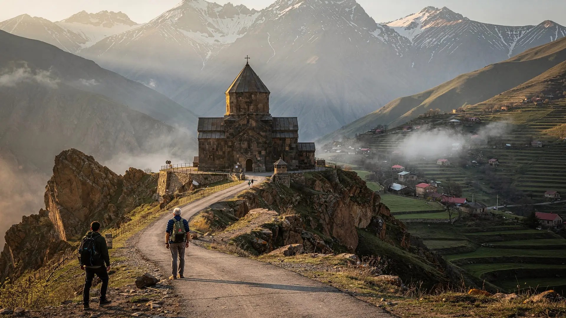
The pervasive mountainous character of Armenia is inseparable from the placement of its religious heritage. Walk to almost any Armenian monastery of significance and you will find it perched on a gorge rim, clinging to a cliff face, built into a cave in a canyon wall, or positioned at the edge of a highland plateau with views into a valley. This is not coincidence.
Pre-Christian Armenian religion was centred on mountain worship — the highland peaks were the dwelling places of gods, the altars of sacrifice, the thresholds between human and divine. When Christianity displaced the old religion in 301 AD, it did so by occupying the same sacred geography. Khor Virap was built above what was already a sacred underground space. Geghard monastery occupies a cave spring that predates Christianity by thousands of years. The canyon-edge monasteries of Hovhannavank and Saghmosavank, Noravank in its red-cliff gorge, Tatev on its basalt promontory — all reflect a religious tradition that consistently associates proximity to dramatic geology with proximity to the divine.
This geological-religious synthesis is one of the things that makes Armenia distinctive as a destination for visitors interested in both landscapes and cultural heritage. You cannot fully experience one without the other. The monastery in the gorge exists because the gorge is sacred; the mountain view from the church window is not incidental but intentional.
Armenian mountains in literature and art
The Armenian relationship with mountains is embedded in the country’s literary and artistic tradition. The medieval court poet Sayat-Nova (18th century) wrote poems using mountain imagery as metaphor for spiritual aspiration. The 20th-century poet Paruyr Sevak — arguably the greatest modern Armenian poet — used the Zangezur highlands as the setting for his most intense works. Martiros Saryan (1880–1972), Armenia’s greatest painter, returned obsessively to the mountain colour palette: the deep blues, volcanic greys, and apricot-earth tones of the Armenian highland.
The Cascade Complex in Yerevan — the monumental stairway that is one of the city’s defining landmarks — houses Armenian mountain landscape paintings alongside contemporary international art in its galleries. A visit to the Cascade (see the Cascade Complex visitor guide) provides cultural context for the mountains you will see outside the city.
Economic role of the mountains: past and present
Armenia’s highland economy has ancient roots. The high summer pastures of Aragats, the Geghama plateau, and the Syunik ranges supported transhumance — seasonal livestock movement to high altitude — from prehistoric times through the 20th century. The petroglyphs of the Geghama plateau are partly records of this herding culture. The same routes used by Bronze Age shepherds are still walked by their successors in some areas.
Modern mountain economy is changing. Tourism is displacing traditional herding on the most accessible routes (Aragats weekends). The Transcaucasian Trail project explicitly aims to create an economic alternative for mountain communities — guesthouses, guide services, food sales — that can support village economies as younger generations move to Yerevan.
The copper mines of Kapan and Alaverdi represent industrial mountain economy; the organic honey and cheese sold at roadside stands in Byurakan and Ijevan represent artisan mountain economy. Both coexist with the hiking economy that has grown rapidly since Armenian independence.
Planning a mountain-focused Armenia trip
For visitors whose primary interest is mountain landscape rather than monasteries or wine, the following itinerary structure prioritises the major geological experiences:
5-day mountain focus from Yerevan:
- Day 1: Yerevan orientation + Cascade viewpoint
- Day 2: Kasakh gorge trail + Amberd fortress + Lake Kari drive (if road open)
- Day 3: Aragats southern summit full day
- Day 4: Drive to Lake Sevan + optional Geghama plateau approach (4WD needed)
- Day 5: Azhdahak plateau petroglyphs (or Dilijan if less experienced)
This itinerary combines road-accessible alpine landscapes with two significant hiking days, three UNESCO-quality monastery stops en route, and the Geghama Bronze Age sites — an efficient mountain-focus trip that still captures Armenia’s cultural depth.