The Janapar Trail: hiking Armenia's coast-to-coast route
Armenia’s original long trail
Before the Transcaucasian Trail arrived with its international funding and social media presence, Armenia had the Janapar. The word simply means “road” or “path” in Armenian, and the concept was straightforward: a continuous walking route from the country’s northern border with Georgia to its southern border with Iran, linking forests, monasteries, mountain passes, and villages in a single unbroken thread.
The Janapar was pioneered by a small group of Armenian hiking enthusiasts in the early 2000s, marked with hand-painted yellow blazes on rocks, trees, and walls rather than the white-red-white system later adopted by the TCT. Sections were documented, local families took in hikers, and a modest community of repeat visitors built up — mostly European and American trekkers who discovered it through word of mouth.
Today the Janapar coexists with the TCT: the two trails overlap in places, diverge in others, and together they form the most complete network of long-distance hiking available in Armenia. Understanding the difference between them helps you plan which route — or combination of routes — suits your style.
Route overview
The Janapar is loosely divided into three macro-sections:
Northern section (Lori and Tavush provinces): The trail enters Armenia from Georgia near the Bagratashen crossing and winds south through Lori, skirting the UNESCO monasteries of Haghpat and Sanahin before climbing into the Tavush highlands. This section crosses the Ijevan ridge and drops toward Dilijan — one of the most rewarding stretches, combining forested canyon views with relatively comfortable village distances.
Central section (Tavush and Gegharkunik): From Dilijan the trail passes through the national park, skirts the northern shore of Lake Sevan, and climbs onto the Geghama plateau — a volcanic highland of extinct craters, rock art, and alpine silence. This central passage is partially overlapping with the TCT but diverges through terrain that the TCT does not always cover.
Southern section (Vayots Dzor and Syunik): The Janapar descends into the wine country of Vayots Dzor — passing near Noravank monastery and the vine-covered villages of the Arpa valley — before climbing again into Syunik province for the final southern push toward Kapan and the Iranian border region.
Yellow blazes vs white-red-white
The Janapar’s yellow blazes are its defining visual identity. Where the TCT uses the international mountain trail standard of white-red-white stripes (common across European trails), the Janapar marks are less formal: a yellow triangle, a yellow dot, or simply a stripe of yellow paint. Their reliability varies enormously. In well-maintained sections near Dilijan, yellow blazes appear every few hundred metres. In remote southern stretches, you may walk for an hour without seeing one.
This inconsistency is not a reason to avoid the trail — it is a reason to carry offline GPS maps. The Janapar route is well-documented on Wikiloc and AllTrails by hikers who have GPX-tracked their walks. Download a current track before you set out.
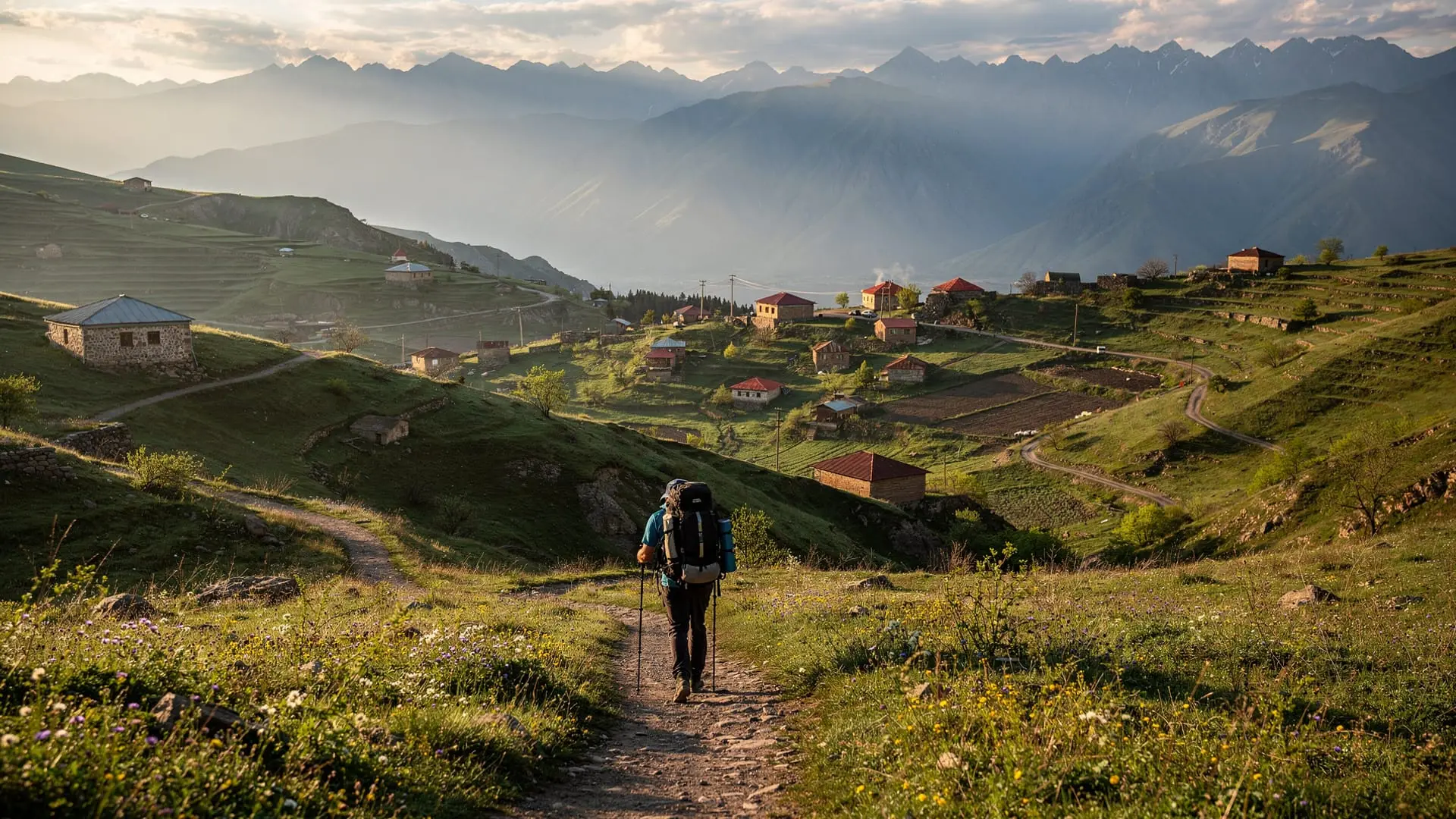
Best day sections
Dilijan corridor (Tavush)
The most accessible and consistently marked section of the Janapar runs through and around Dilijan National Park. Starting from Dilijan town, the trail climbs through beech forest to a ridge overlooking Haghartsin monastery before descending toward Gosh village and Lake Parz. This stretch can be broken into comfortable half-day or full-day sections. See the Dilijan National Park hikes page for trailhead details and difficulty ratings.
Haghpat approach via Lori
Approaching Haghpat monastery on foot via the Janapar — rather than by car from Alaverdi — transforms the visit. The trail descends through terraced hillsides and orchards, arriving at the monastery walls with the kind of perspective that only a walking approach provides. Combined with a visit to nearby Sanahin, this makes for a memorable two-day loop from Alaverdi.
Noravank gorge section (Vayots Dzor)
South of Areni village, the Janapar climbs the cliffs above the Arpa river canyon before descending to Noravank monastery from above — a far more dramatic arrival than the standard car approach from below. This section is moderately demanding (500 m of elevation gain) and takes roughly 4–5 hours round trip.
Practical logistics
Start points: Dilijan and Ijevan are the most common entry points for day-section hikers. For the full northern approach, the Bagratashen border crossing feeds into Alaverdi, from where you can pick up the trail heading south.
Accommodation: Janapar hikers rely on the same guesthouse network as TCT hikers. In Dilijan, the Hotel Old Dilijan Complex and several smaller B&Bs cater to trail users. In Lori, Tufenkian Avan Dzoraget Hotel is the premium option. For simple trail accommodation, community guesthouses charge 5,000–8,000 AMD per night with breakfast.
Food and water: Dilijan and Ijevan have supermarkets. Village shops exist en route but stock is unpredictable; carry at least two days of food on most sections. Water from mountain streams is generally reliable in Tavush and Lori but should be treated or filtered.
Transport back: For day sections, the most common approach is to arrange a taxi or shared marshrutka pick-up at the trail’s end point. Marshrutkas from Dilijan to Yerevan run throughout the day (1h 45min, under 1,500 AMD). From Ijevan, frequency is lower but services run to Yerevan’s Kilikia terminal.
Guided hiking on the Janapar corridor
The Dilijan National Park lake trek from Yerevan is the most popular guided introduction to Janapar-corridor terrain, covering the forest and lakeside sections that overlap with the trail’s best-marked stretches.
For a multi-day taste of the full north-south Janapar concept, the 5-day private hiking and cultural tour from Yerevan combines Lori highlands and Tavush forests in a format that mirrors the trail’s northern section without requiring independent navigation.
Janapar vs TCT: which trail to choose?
The two trails are complementary more than competing, but there are genuine differences:
| Factor | Janapar Trail | Transcaucasian Trail |
|---|---|---|
| Marking | Yellow blazes (inconsistent) | White-red-white (more systematic) |
| Documentation | Wikiloc/AllTrails GPX tracks | Official website with downloadable GPX |
| Philosophy | Community-built, organic | International NGO-backed, structured |
| Best condition | Northern (Tavush/Lori) | Northern (Tavush/Lori) — overlap |
| Southern sections | Partially marked, adventurous | Still being built, rougher |
| Culture links | Strong (monasteries on route) | Strong but varies by section |
In practice, experienced hikers often blend both, following whichever route has better marking or more interesting terrain in each section. The two trails share significant overlap in Tavush, diverge in Gegharkunik, and converge again in parts of Syunik.
For comparison with the hiking options available across the border, the hiking Armenia vs Georgia guide gives a balanced perspective on where each country excels.
Connecting the Janapar to other Armenia highlights
The genius of the Janapar’s alignment is that it weaves through the country’s religious and cultural landmarks rather than avoiding them. Day hikers following the trail near Lori walk to Haghpat and Sanahin; southern sections pass close to Noravank. The Transcaucasian Trail Armenia section guide provides additional context on overlapping terrain.
Hikers completing the full southern Syunik section will want to read the Mount Khustup trek guide — the sacred Khustup massif sits just east of the Janapar corridor and makes an excellent detour for fit hikers.
Season and conditions
The Janapar’s yellow-blaze sections in Tavush and Lori are best from late April through October. The central Geghama plateau section needs snow-free conditions (June–September). Southern Syunik passes are typically accessible from mid-June to early October. Winter hiking on low Tavush sections is possible for experienced cold-weather hikers but waymarking under snow is challenging.
The When to hike in Armenia guide covers month-by-month conditions across all the major trail systems, with Aragats and highland pass access included.
Frequently asked questions about the Janapar Trail
Is the Janapar Trail a complete, continuous route in 2026?
Partially. The northern section (Lori and Tavush) is the most coherent and continuous. The central and southern sections have gaps requiring GPS navigation between blazed sections. The trail has never been as systematically documented as the TCT, but dedicated community work continues to improve its documentation. Check current trip reports on Wikiloc before any remote section.
How long would it take to walk the entire Janapar?
A coast-to-coast traverse of the full route — if walking all sections — would take approximately 25–35 days depending on pace, daily distances, and rest days. Most hikers do not attempt the full route in one go; a typical approach involves returning annually to complete sections progressively.
Can beginners hike the Janapar?
Some sections are excellent for beginners, particularly the Dilijan National Park corridor. Remote Syunik sections are not suitable for inexperienced hikers without a guide. The Armenia trekking gear checklist outlines the minimum equipment for safe independent hiking.
Are there maps available for the Janapar?
No official printed map exists for the complete Janapar. The best resources are Wikiloc (search “Janapar Trail Armenia”), AllTrails, and the transcaucasiantrail.org map (which includes Janapar overlap sections). The maps.me app with downloaded Armenia map works as a reliable offline backup.
Where should I base myself for Janapar day hikes?
Dilijan is the best overall base: comfortable accommodation, multiple trailheads within walking or taxi distance, and good marshrutka connections to Yerevan. Alaverdi works well for the Haghpat approach section in Lori.
The Janapar in the context of Armenian hiking culture
The Janapar Trail emerged from a grassroots Armenian hiking revival that began in the late Soviet period and accelerated after independence in 1991. Unlike many long-distance trails that are professionally designed and commercially developed from the outset, the Janapar was built by enthusiasts — hikers, naturalists, and academics who simply started walking, marking what they walked, and publishing their routes.
This origin story matters for the experience it creates. The Janapar is not curated in the way that the GR network in France or the national trails in Britain are curated. It has rougher edges, more discovery, and a directness about difficulty that overtly commercial trails sometimes smooth away. The communities along the route — the villages in Tavush where a guesthouse might be a family’s spare bedroom, the shepherd who shares bread and local cheese in a meadow above Haghpat — are part of the Janapar experience in a way they may never be once the route is fully commercialised.
Walking the Janapar now, in its imperfect, partially-finished state, gives access to an Armenia that most organised tours do not show.
Practical section guide: Lori highlights
The Lori section of the Janapar connects three of the most historically significant sites in northern Armenia within a single walkable corridor.
Alaverdi to Haghpat (5 km, 2h): From the copper-mining city of Alaverdi in the Debed gorge (300m altitude), the Janapar climbs steeply through terraced hillsides and fruit orchards to Haghpat monastery at 940m. The elevation gain is the challenge; the reward is arriving at the UNESCO World Heritage monastery through the agricultural landscape its medieval monks would have known.
Haghpat to Sanahin (6 km, 2.5h): The trail follows the ridge between the two great Zakarian-era monasteries, passing viewpoints above the deep Debed gorge. Both Haghpat and Sanahin are 10th–13th century masterworks of Armenian religious architecture — reaching both on foot in a single morning is one of the most culturally dense half-days available on any Armenian trail.
Sanahin to Akhtala (14 km, 5h): The longer western extension toward Akhtala monastery follows forest paths above the Debed. Akhtala is the site of some of the finest medieval frescoes in the South Caucasus — Byzantine-influenced paintings from the 13th century that survive in remarkable condition in the main church.
Practical section guide: Vayots Dzor highlights
The Janapar’s southern passage through Vayots Dzor is less well documented than the Tavush and Lori sections but contains some of the most geologically dramatic terrain on the entire route.
The Arpa river canyon between Areni village and Noravank monastery is a highlight: red-orange cliffs of Devonian limestone (unusual in a predominantly volcanic country) rise 200m above the river. The Janapar follows the canyon edge in places, offering cliff-top perspectives that the road traveller in the valley below never sees.
At Noravank itself, the trail arrives through the canyon from above rather than the standard approach from below — arguably the finest arrival angle for a monastery in all Armenia.
From Noravank, the Janapar continues south-east through the Vayots Dzor highlands, crossing passes above 2000m before descending toward the Syunik zone. This central-south section requires the most expedition-style planning: no guesthouses, long distances between villages, and variable marking.
Planning resources and community
Beyond transcaucasiantrail.org (which covers TCT overlap sections), the best current resource for the Janapar is the hiking community on Armenian outdoor forums and the AllTrails/Wikiloc database of user-generated GPX tracks. Search “Janapar” on either platform for accumulated trip reports covering every major section. The quality and recency of reports varies significantly — look for tracks uploaded in the last 1–2 years for the most reliable condition information.
The Hiking Club of Armenia (based in Yerevan) organises regular group walks on both the Janapar and TCT corridors and is the best source for local knowledge, seasonal conditions, and guide connections. Their social media presence is active and they welcome contact from visiting hikers.