Lake Kari: alpine day trip on Aragats
Armenia’s highest road destination
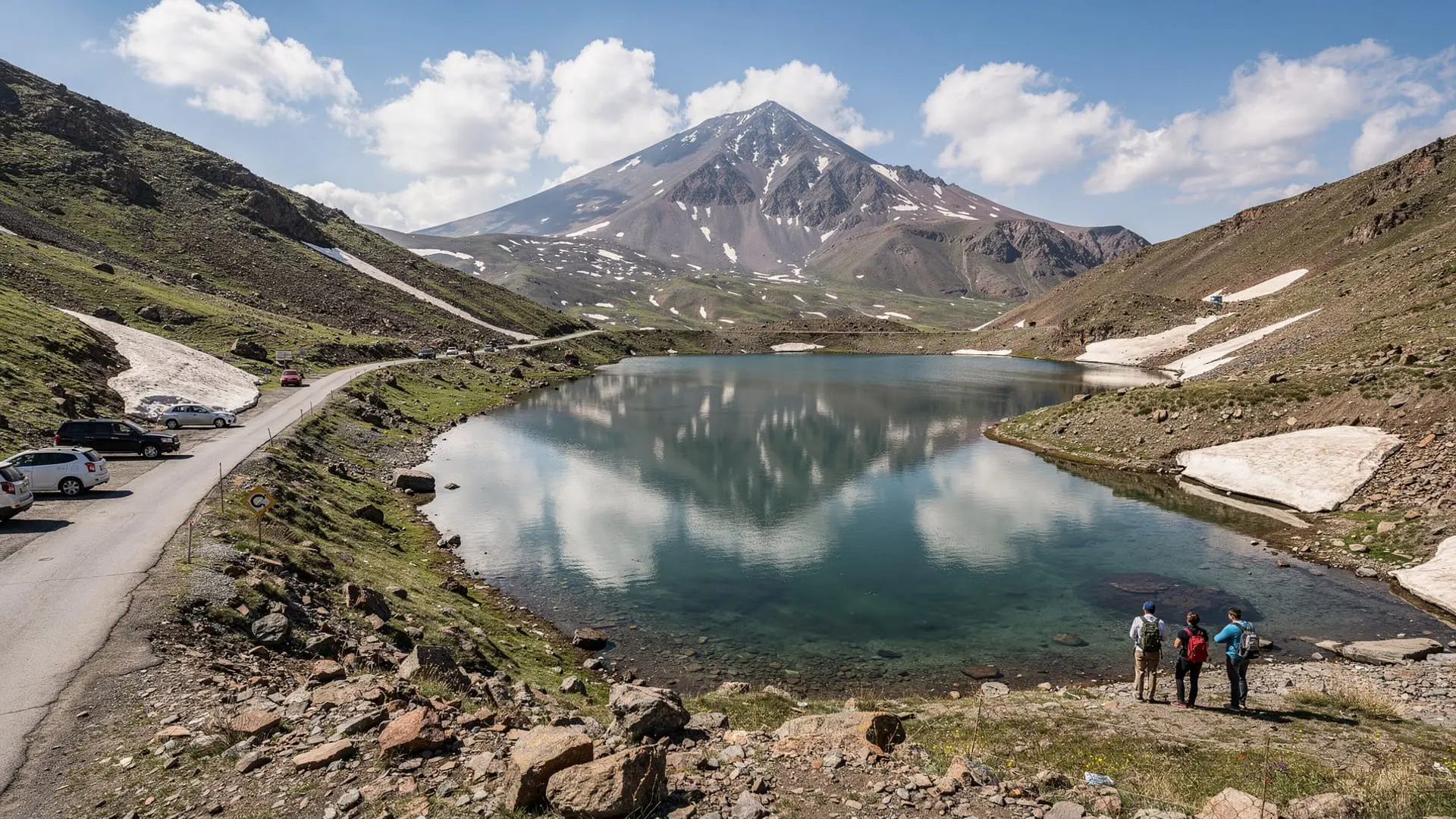
Lake Kari sits at 3200m altitude on the southern rim of the Mount Aragats caldera — the highest point in Armenia reachable by paved road. The lake itself is small (a few hundred metres across), intensely blue in the thin mountain air, and surrounded by the stark volcanic geology of the upper caldera. On summer days the combination of altitude light, clear water, and the four Aragats peaks encircling the horizon creates a scene of extraordinary visual drama.
For visitors to Armenia who want to experience high-altitude landscape without the commitment of a summit hike, Lake Kari is the answer. You can drive to 3200m, step out into air that is noticeably thinner than Yerevan’s (which itself sits at 900m), photograph the peaks reflected in the lake, and return to the city the same day. Alternatively, the lake is the starting point for all four Aragats summit routes — from a gentle ascent of the southern peak to the technical challenge of the northern summit.
Getting to Lake Kari
The road: From Yerevan, the drive to Lake Kari via Aparan and Byurakan takes about 1h 30min in good conditions. The lower section is fully paved; the upper 12 km deteriorates to an unpaved track that requires confidence if not a high-clearance vehicle. Standard cars make this road in dry conditions; a small SUV or high-clearance car is more comfortable.
Road opening: Typically second half of June, after snowploughs clear the upper section. The road closes in early October. Do not attempt the upper section without checking road conditions locally — the snowplough team in Aparan can usually advise on the current state. In extremely snowy years, the road may be passable in places but blocked at a critical section; local knowledge matters.
By marshrutka: No direct public transport reaches Lake Kari. The closest marshrutka goes to Aparan (from Yerevan Kilikia station, 1h). From Aparan, a taxi to Lake Kari costs approximately 6,000–9,000 AMD one-way. Negotiate the return time in advance.
By organised tour: The most convenient option for visitors without a car. All Yerevan tour operators offer Aragats day trips that include Lake Kari as the main stop before any summit attempt.
What to do at the lake
Simply be at altitude
The experience of arriving at 3200m deserves a moment of unhurried presence. Walk to the lake shore, find a boulder to sit on, and give your breathing a few minutes to adjust. The view from the southern rim takes in the caldera’s sweep — the three higher peaks visible to the north — and the silence at this altitude is unusually complete, interrupted only by wind and occasionally the distant call of alpine choughs.
Many visitors from Yerevan spend an hour or two at the lake without attempting any summit — eating a picnic, photographing the reflections, walking the short path around the lake perimeter, or simply enjoying the 15°C air when the city below is baking at 35°C.
Hiking from Lake Kari
The lake is the departure point for all four Aragats summit routes:
- Southern peak (3879m): 4–5h round trip, no technical difficulty. The most popular route. Details at the Aragats southern summit guide.
- Eastern peak (3916m): 6–7h round trip, rocky ridge.
- Western peak (4080m): 8–10h round trip, harder terrain.
- Northern peak (4090m): 10–12h round trip, technical. Guide required.
The full four-peaks context is at the Mount Aragats four-peaks guide.
Wildflower season (late June–mid July)
The alpine meadows around Lake Kari produce some of the finest wildflower displays in Armenia during the brief window between snowmelt and high summer. Caucasian alpine species — including endemic Aragatsotn plants not found elsewhere — carpet the slopes around the lake in late June. Photographers should aim for this window specifically.
Photography
Lake Kari is one of the best-known landscape photography locations in Armenia. The most photographed composition: caldera peaks reflected in the lake, shot from the southern shore in the morning before wind disturbs the surface. Afternoon light on the northern peaks adds warm colour but the surface reflection is usually lost by then.
The altitude light is dramatically different from sea-level photography — the sky is a deeper blue, shadows are harder, and the contrast range is challenging for cameras. A graduated ND filter or exposure bracketing helps manage the bright sky against the darker lake.
Facilities at the lake
Café: A basic seasonal café operates at the lake in summer (June–September), serving hot drinks, simple food (sandwiches, bread, eggs), and cold drinks. It is not gourmet, but the hot tea after a summit descent is genuinely welcome. The café may not open until late June; don’t rely on it as your only food source.
Toilets: Basic facilities exist at the café building. No facilities on the mountain above.
Meteorological station: A Soviet-era weather station operates at the lake, now largely automated. It is not open to visitors but its presence gives the plateau a slightly surreal quality — a small orange building in an otherwise completely wild landscape.
Accommodation: There is no formal accommodation at the lake. Some hikers camp informally on the flat ground near the café (the caretakers tolerate this for an informal fee). For comfort, base yourself in Byurakan village (1400m, 30 min below) where several guesthouses operate.
Altitude effects
At 3200m, most visitors arriving from Yerevan (900m) will feel the altitude within the first 30 minutes. Typical mild symptoms: slight breathlessness on exertion, a background awareness of the elevated heart rate, possibly a mild headache. These are normal and manageable.
What helps: Arrive well hydrated (drink 2 litres of water the day before and the morning of your visit), take it slow for the first 30 minutes, avoid alcohol the evening before. If you feel genuinely unwell (severe headache, nausea, disorientation), descend — the symptoms resolve quickly with lower altitude.
Children: Most children aged 8+ handle Lake Kari altitude without significant difficulty. Be attentive to any complaints of headache and don’t rush around on arrival.
Seasonal notes
Late June: First opening of the road. Snow still patches the north-facing slopes. Lake surface may still be partially ice-covered in early June. Wildflowers just beginning. Quieter than peak season.
July: Peak summer. Warm, sunny, frequent afternoon cloud build-up with occasional thunder. Crowded at weekends with Yerevan day-trippers. Start early to beat both crowds and weather.
August: Similar to July. Afternoon storms more frequent. The landscape is at its driest and most lunar-looking. Good visibility before the afternoon cloud.
September: The best month for Lake Kari. Cooler temperatures (8–15°C at the lake), fewer crowds, excellent visibility, and the surrounding peaks begin to catch early snow on north-facing aspects. Extraordinary photography conditions.
Early October: The road may close at any time. Check conditions before driving up. Snow on the upper section can appear overnight. If you catch it before the closure, October at Lake Kari is hauntingly beautiful — frost on the ground, ice forming at the lake edge, total silence.
Combining Lake Kari with Amberd and other Aragatsotn sites
The natural Aragatsotn day itinerary combines Lake Kari with Amberd fortress (on the same road at 2300m) and the Hovhannavank–Saghmosavank monastery pair. See the Amberd fortress guide and the Kasakh gorge trekking guide for details on those sites.
The Armenia volcanic landscapes guide provides geological context for the landscape visible from Lake Kari — the caldera, the basalt flows, and the volcanic origin of the entire Aragats massif.
A guided Aragats northern summit tour from Yerevan uses Lake Kari as its base point — the most immersive way to experience the lake is as the launch point for a serious summit attempt.
Frequently asked questions about Lake Kari
How cold is Lake Kari in summer?
Air temperature at the lake in July–August is typically 10–20°C — significantly cooler than Yerevan. A fleece or light jacket is appropriate even for a non-hiking visit. Wind adds a chill factor, particularly on the exposed lake shore. September days can drop to 5–10°C.
Is there swimming in Lake Kari?
Technically possible in late July–August when the lake is fully open and water temperature reaches perhaps 8–10°C. A few hardy locals swim; most visitors are content to look. No designated swimming area or lifeguard; the lake is shallow near the shore but drops off in the centre.
Can I camp overnight at Lake Kari?
Informal camping near the café is tolerated in summer (check with the caretaker on arrival). No designated campsite or facilities for camping. A 3-season sleeping bag is necessary even in July — nights at 3200m can drop below freezing. The Armenia trekking gear checklist covers camping kit for high-altitude stays.
Is there a path around the entire lake?
A rough path circles the lake perimeter, taking about 45 minutes at a gentle pace. The southern shore (near the café) is most accessible. The northern shore is rougher and requires stepping over boulders. The eastern approach toward the caldera interior becomes the start of the hiking trails to the summit peaks.
Can I see all four Aragats peaks from Lake Kari?
Three of the four peaks (west, north, east) are clearly visible from the lake’s southern shore. The southern peak is directly above you and somewhat harder to see as a distinct summit from the lake level. Move to the caldera rim edge (10 min walk from the café) for the best view of all four peaks in relation to each other.
Lake Kari in different lights: a photographer’s guide
Lake Kari is one of the most photographed locations in Armenia, and for good reason: the combination of calm alpine water, volcanic peaks, and extraordinary altitude light creates conditions that reward careful photography. The challenge is that the most popular visiting times (midday weekends) are the worst photographic conditions.
Dawn (recommended): Arrive at the lake the evening before and camp, or drive up extremely early from Byurakan (30 min from the lake). At dawn, the caldera rim peaks catch first light while the lake surface is still in shadow — the contrast between the warm peak colours and the dark, glassy water surface is extraordinary. Cloud inversions (common in summer) fill the valleys below, leaving the Aragats peaks floating above a white sea.
Late afternoon: The western peak catches directional light from the west in the late afternoon. The shadows on the caldera wall lengthen, revealing geological texture. If afternoon clouds have cleared (which sometimes happens after 5pm), this is a second excellent window.
Blue hour: On long summer evenings, the period after sunset when the sky turns deep blue and the lake surface mirrors it gives the most ethereal results. The volcanic rock surroundings darken while the water holds colour.
What to photograph: The classic composition from the south shore — peaks reflected in the lake — is a natural starting point. More interesting: the caldera texture from the eastern rim; the silhouette of the meteorological station against the peaks; the abstract surface patterns on the lake when light wind creates ripple structures.
The drive from Yerevan: a landscape narrative
The road from Yerevan to Lake Kari is itself a rewarding experience that rewards attention:
Yerevan to Aparan (60 km): The M3 highway climbs gradually from the Araratian plain (900m) through the volcanic foothills of Aragatsotn. Aragats first appears on the left horizon around the 40 km mark — initially as an undifferentiated mass, gradually revealing its four peaks as you draw closer.
Aparan to Byurakan (20 km): The town of Aparan is the last city-scale settlement before the mountain. The road narrows and climbs through fruit orchards (apricots in early summer, apples in autumn) and past the Byurakan observatory ridge.
Byurakan to Amberd (12 km): The road steepens and the vegetation changes — the orchards give way to alpine meadow, then rocky highland pasture. The basalt flows from Aragats’s past eruptions become visible as dark sheets in the road cuts.
Amberd to Lake Kari (15 km): The final approach crosses 2000m, 2500m, 3000m. The tree line falls away. The sky deepens in colour — the difference between sky blue at 1000m and sky blue at 3200m is visible to the naked eye. Snow patches appear on north-facing slopes. The lake appears suddenly below a final rise.
Lake Kari and the Aragats ecosystem
At 3200m, the Lake Kari area supports a specialist alpine ecosystem that few Armenian visitors know about. The lake itself (being a closed basin with no outflow) has a chemistry influenced by the volcanic rock it sits in — slightly alkaline, cold, and with very low biological productivity. This means the water is clear but nearly lifeless as a fishing site.
The surrounding meadows, however, are botanically rich. The alpine plant community includes several Armenian endemics — species found nowhere else on Earth — concentrated in the Aragats caldera zone. Cushion plants, alpine gentians, and dwarf willow species occupy the basalt scree. Some of the most interesting botanical diversity is in the microclimates created by north-facing rocks where snow lies late: here, plants that typically occupy sub-alpine zones persist at anomalously high altitude.
Birds at Lake Kari: alpine chough (abundant, noisy, acrobatic — the comedian of the caldera), snowfinch, water pipit, and occasional alpine swift. Raptors including golden eagle and common buzzard hunt above the caldera rim. The Armenia 3-day bird-watching and hiking tour includes Aragats caldera zone birdwatching as a programme element.
Planning your visit: step-by-step checklist
- Check Lake Kari road status (open mid-June to early October; call locally or check Armenian driving forums for current year)
- Download offline map: maps.me Armenia + GPS track for your planned route
- Check weather forecast: meteo.am the evening before; aim for stable high pressure
- Depart Yerevan no later than 7am for a summit attempt, 9am for a view-only visit
- Fuel in Aparan (last reliable fuel station before the lake)
- Bring: 3 litres water, warm layer, waterproof jacket, sunscreen SPF50, food for the day
- Note: Amberd fortress is on the way up — 30 min visit recommended en route
- Return before 5pm to avoid driving the upper road in fading light