Mount Aragats: hiking the four peaks
Four peaks, one ancient volcano
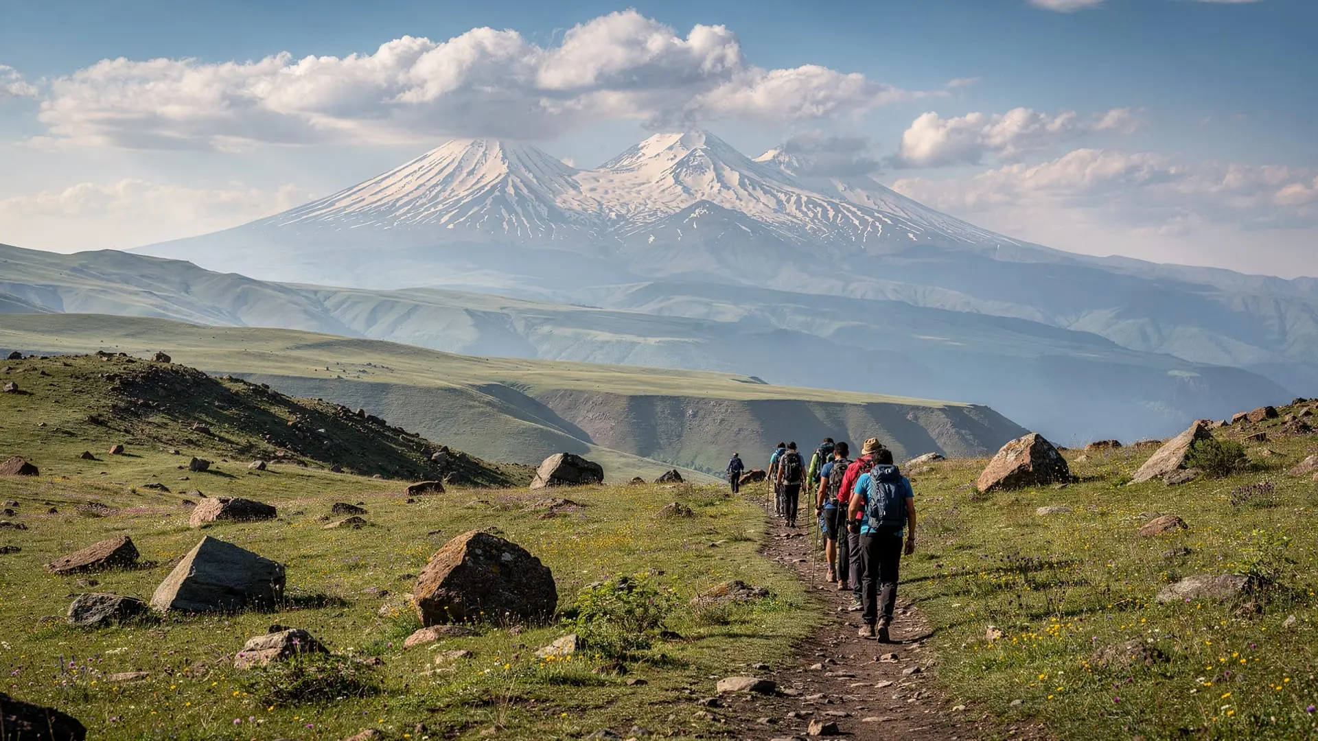
Mount Aragats is not a single cone but a vast collapsed stratovolcano with four distinct summits arranged around a central caldera — the most dominant massif in Armenia and the highest point in the Republic at 4090m (northern peak). On clear days its snow-capped silhouette dominates the Araratian plain from Yerevan, some 50 km to the south. The mountain’s name may derive from the Armenian “Ara-gats” — the throne of Ara, a legendary king — and its four peaks each carry their own character, difficulty, and rewards.
For hikers visiting Armenia, Aragats represents the most accessible genuine high-altitude summit in the country. Unlike Ararat (which is in Turkey and inaccessible from the Armenian side), Aragats is entirely within Armenia, reachable by road to 3200m, and climbable by fit non-mountaineers on its two lower peaks. The northern peak involves glacier navigation and is best attempted with a guide.
The four peaks at a glance
| Peak | Altitude | Character | Difficulty |
|---|---|---|---|
| South | 3879m | Gentle slopes, popular day hike | Moderate |
| East | 3916m | Rocky ridge, good views of caldera | Moderate-hard |
| West | 4080m | Longer approach, some scrambling | Hard |
| North | 4090m | Highest, glacier remnants, technical | Very hard |
Starting point: Lake Kari
All four Aragats summit routes begin from the vicinity of Lake Kari (3200m), a small alpine lake nestled in the caldera’s southern rim. The road from Yerevan to Lake Kari (via Aparan and Byurakan) is paved most of the way and typically opens around mid-June when snowploughs clear the upper section; it closes again by early October. Driving time from Yerevan is about 1h 30min in good conditions.
At the lake there is a basic café (open in summer season), toilets, and a meteorological station. No formal accommodation exists at the lake itself, but a guesthouse in nearby Byurakan or the army-run camp at the lakeshore is used by hikers arriving late.
During summer the lake area can be busy on weekends with day-trippers from Yerevan, picnickers, and shepherds moving sheep between pastures. Arrive early — both to beat crowds and to summit before afternoon thunderstorms develop.
Southern peak route (3879m)
Distance: 8 km round trip from Lake Kari
Elevation gain: 680m
Time: 5–6h round trip
Difficulty: Moderate
The southern peak is the most popular Aragats summit and the recommended first objective for hikers visiting the mountain for the first time. From Lake Kari, follow the obvious path south-west along the caldera rim. The trail is wide and well-trodden, gaining elevation gradually across rocky alpine terrain. The final approach steepens over loose scree but remains non-technical.
Summit views encompass the full caldera, the three other peaks (the northern summit visibly crowned with snow well into August), and on exceptionally clear days, the shape of Mount Ararat across the border in Turkey. This is one of the few places in Armenia where you can see Ararat’s full mass — the plains below Khor Virap have the most famous viewpoint, but the Aragats south summit view is higher and more encompassing.
The descent follows the same route; allow more time than expected as scree descents tire knees. For a detailed page on this route specifically, see the Aragats southern summit guide.
Eastern peak route (3916m)
Distance: 10 km round trip
Elevation gain: 716m
Time: 6–7h round trip
Difficulty: Moderate-hard
The eastern peak involves a longer traverse along the caldera rim from Lake Kari heading east before the final climb. The ridge is rockier than the southern approach with some mild scrambling near the top. The reward is the best close-up view into the caldera itself — a vast bowl of frost-shattered basalt that reveals the volcano’s geological scale.
The eastern summit is noticeably quieter than the south; most day hikers stop at the southern peak. Starting early (before 7am) from Lake Kari makes a south-east circuit feasible in a single long day.
Western peak route (4080m)
Distance: 14 km round trip
Elevation gain: 880m
Time: 8–10h round trip
Difficulty: Hard
The western peak is a serious undertaking as a day hike. The approach from Lake Kari crosses the northern part of the caldera floor (boggy in early season) before climbing steeply to the ridge. Some sections involve hands-on scrambling over large boulders. Altitude sickness is more likely here — acclimatise with a night at altitude (Byurakan or the lake) before attempting this peak.
The views from the west summit extend into Turkey, with Ararat’s outline occasionally visible above the western horizon. This is one of the finest panoramic viewpoints in Armenia.
Northern peak route (4090m) — technical
Distance: 18+ km round trip
Elevation gain: 890m
Time: 10–12h round trip
Difficulty: Very hard / technical
The northern summit is Armenia’s highest point. It differs from the other three peaks in that it retains permanent snowfields and small glacier remnants on its north and north-west faces. Navigation in fog is hazardous; the terrain is loose and the approach long. Crampon and ice axe experience is an asset for early-season attempts (June–early July). The northern peak is firmly in the domain of experienced mountaineers or those hiring a local guide.
A guided ascent to the northern summit is the safest and most informative option for those without Aragats-specific experience.
The Aragats northern summit guided tour from Yerevan is specifically designed for this challenge — the guide handles route-finding in the complex upper terrain and provides the safety margin that makes the northern peak genuinely accessible to fit hikers.
Guided day hikes on Aragats
For hikers who want summit success on the accessible southern peak without the planning overhead, organised tours handle transport, guide service, and timing.
The private southern peak day hike from Yerevan covers the full round trip with a local guide who knows the mountain in all conditions — particularly valuable on days when clouds roll in and the upper section becomes harder to navigate.
When to climb Aragats
Mid-June to early September is the primary window. The Lake Kari road typically opens in the second half of June. July and August are the driest months; thunderstorms build in the afternoon so an early start is essential (summit before noon). September remains excellent — cooler, clearer, and less crowded.
May–early June: The road to Lake Kari remains closed or snow-covered. Experienced mountaineers with snow gear can approach on foot from lower villages (Byurakan or Agarak village), but this adds 4–5 hours each way.
October: The road typically closes by late September to early October. Snowfall becomes possible at any time. Not recommended for inexperienced hikers.
Winter: The mountain is for winter mountaineers only. Snow depth above 3000m can reach several metres. Avalanche risk exists on north-facing slopes.
Acclimatisation and altitude considerations
At 4090m, the northern peak sits at an elevation where altitude sickness is a genuine risk for visitors arriving from sea level. The southern peak at 3879m is accessible enough that most acclimatised hikers manage without issues, but arriving at Lake Kari (3200m) and spending a night there before climbing significantly reduces the risk.
Symptoms to watch: headache, nausea, loss of appetite, dizziness. Descend immediately if symptoms are severe or worsen. See a doctor before the trip if you have any cardiovascular concerns.
What to bring
A full kit list is in the Armenia trekking gear checklist, but Aragats-specific essentials are: waterproof jacket and trousers (weather changes fast), sun protection at altitude (UV is intense above 3000m), gaiters for scree (useful on all four peaks), trekking poles (essential for descent), and a warm mid-layer even in July.
Getting to Lake Kari
Self-drive: From Yerevan take the M3 highway north via Aparan, then follow signs for Byurakan and Mount Aragats. Allow 1h 30min in clear conditions. The road surface above Byurakan is rough and a high-clearance vehicle is preferable for the final 12 km to the lake.
Marshrutka + taxi: Marshrutkas run from Yerevan’s Kilikia station to Aparan; from Aparan, a taxi to Lake Kari costs around 6,000–8,000 AMD one-way (negotiate in advance). No direct marshrutka reaches the lake.
Organised tour: The most practical option for those without a car. All major Yerevan tour operators offer Aragats day trips; GYG-listed tours include return transport, guide, and often entry/parking fees.
Connecting Aragats to a wider Aragatsotn itinerary
Aragats sits in Aragatsotn province, which packs an extraordinary density of attractions. En route from Yerevan, the Amberd fortress on the slopes of Aragats is a compulsory stop — a 10th-century Armenian fortress at 2300m with stunning mountain views. Lake Kari’s own guide covers the day-trip experience without summiting. Nearby, the Armenian Alphabet Monument and the monasteries of Hovhannavank and Saghmosavank all sit within the same half-day radius.
Frequently asked questions about hiking Mount Aragats
Do I need a guide to climb Aragats?
For the southern and eastern peaks, an experienced hiker comfortable with navigation and altitude does not strictly need a guide. For the western peak and especially the northern summit, a local guide is strongly recommended. Guides can be arranged through Yerevan tour operators or via community contacts in Byurakan.
Can I drive to the summit of Aragats?
No. The road ends at Lake Kari (3200m). All four summits require hiking from the lake; the shortest (southern peak) is still a 4–5 hour round trip on foot.
Is there mobile phone signal on Aragats?
Signal is present at Lake Kari and on the lower slopes but disappears for significant stretches of the upper mountain. Download offline maps before leaving Yerevan and inform someone of your intended route and return time.
Are there toilets or facilities on the mountain?
Basic facilities exist at Lake Kari (café and toilets, open June–September). Above the lake there are no facilities. Carry out all waste; leave-no-trace principles apply.
Can I do a two-peak or three-peak day?
Experienced, fit hikers have combined the southern and eastern peaks in a single long day (12+ hours). Combining any three peaks in one day is an extreme undertaking for the Aragats terrain and not recommended unless you are highly experienced at altitude. The western peak alone is a full day.
What time should I start hiking?
Aim to leave Lake Kari by 6–7am for any summit attempt. Afternoon thunderstorms are common from July onwards and typically build between 1–3pm. Being off the summit ridge by 1pm is a sensible rule of thumb.
Is Aragats climbable without a car?
Yes, but logistics are complex. Take a marshrutka from Yerevan to Aparan, then negotiate a taxi to Lake Kari. Alternatively, a guided tour is by far the simplest solution for carless visitors.
Aragats as a geological object
Standing at Lake Kari and looking at the four surrounding peaks, it takes a moment to understand what you are looking at: the inside of a collapsed volcano. The caldera — the bowl formed when the magma chamber below a stratovolcano empties or subsides — is roughly 3 km across at Lake Kari’s level. The four peaks are remnants of the original crater rim, left standing when the centre collapsed.
The lava and pyroclastic deposits of Aragats were laid down over roughly 2–3 million years. The youngest volcanic materials (flows of basalt and andesite visible on the lower slopes) may date to the Pleistocene epoch — geologically recent enough that early humans walking the Armenian plateau may have seen Aragats in a more active state. There are no historical records of eruptions; the volcano is considered dormant.
The rock underfoot on all four peak approaches is the same dark grey-black volcanic basalt and andesite — some of the same material that provided building stone for the medieval monasteries of Aragatsotn and the distinctive dark blocks of many Armenian church walls. Picking up a piece of scree from the Aragats southern summit and placing it next to a corner stone of Amberd fortress reveals the connection: same volcanic source, one weathered by four million years of altitude exposure, the other shaped by a medieval mason’s chisel.
Safety considerations for all routes
Avalanche risk: On the northern peak route in winter and early season (through June), avalanche risk exists on north-facing slopes. This is a primary reason the northern summit requires experienced mountain leadership.
Lightning: All summit ridges are exposed. The Aragats caldera acts as a funnel for afternoon convective storms — if you see thunderheads building in the west before noon, descend. Lightning fatalities have occurred on the Aragats ridges. The rule is firm: be off all exposed ridgelines by noon in summer.
Getting lost in fog: The caldera floor is featureless in fog. The rim trails can be difficult to follow when visibility drops to 50m. Always carry GPS with downloaded tracks. Navigation by compass bearing on Aragats is feasible for experienced navigators but fog disorients quickly on the flat caldera floor.
Water: No surface water on any of the summit routes above Lake Kari. Carry a minimum of 2.5–3 litres for a summit day. The café at the lake can refill bottles if it is open.
Cultural context: Aragats in Armenian identity
Aragats holds a different place in Armenian national consciousness than Ararat. Ararat — across the closed border in Turkey — is the unattainable symbol, the sacred mountain seen but unreachable. Aragats is the mountain you can actually climb, the mountain entirely within Armenian soil. For many Armenians, particularly young people and diaspora visitors making their first trip to the homeland, climbing Aragats is a statement of presence — not just visiting Armenia, but standing on its highest accessible point.
Summer weekends at Lake Kari fill with Armenian families: parents lifting young children over the first boulders of the southern peak path, teenagers racing each other up the scree, older hikers moving slowly and deliberately toward the summit cairn. It is a genuinely democratic mountain, open to the full spectrum of Armenian society in a way that Khustup or the Geghama peaks are not.
This cultural accessibility is part of Aragats’s appeal for international visitors too. Sharing the summit with Armenian families — handing out dried apricots from someone’s pack, being asked which country you came from, having a grandfather point out Ararat in the distant haze — creates encounters that a more remote mountain would not offer.
Descent options and circuit routes
Most hikers ascend and descend the same route. For those who want variety on the southern and eastern peaks, a partial caldera circuit is possible in good conditions:
South-East circuit (fit day hikers): Ascend the southern peak via the standard route from Lake Kari; descend via the eastern ridge toward the caldera floor; traverse the caldera floor back to the lake (boggy in early season). Total time: 8–9 hours. This gives views into the caldera from two different angles and passes through the zone where alpine wildflowers are densest in late June.
West approach variation: The western peak can be approached from a different road than Lake Kari — from the north-west, via Aragatsavan village. This route is less documented and requires good navigation, but gives a completely different perspective on the mountain for experienced hikers returning to Aragats for a second visit.