Aragats southern summit: easiest 4,000m peak
The most accessible high-altitude summit in the South Caucasus
Aragats southern summit at 3879m is not technically a 4000m peak — it falls 121m short of that psychological threshold — but standing on it feels every bit as monumental. The views across the Armenian highlands, north toward the caldera, south over the Araratian plain, make it one of the most rewarding hikes in the entire country. And unlike the northern summit (4090m, technical, requiring experience), the southern peak is genuinely within reach of any fit hiker on a good day.
The summit has become a rite of passage for visitors to Armenia who want to go beyond monasteries and city culture into raw mountain terrain. It is the starting point that opens the door to Aragats — most hikers who summit here return for one of the harder peaks.
Route from Lake Kari
Trailhead: Lake Kari, 3200m (parking area at the southern shore)
Summit altitude: 3879m
Elevation gain: 679m
Distance: approximately 8 km round trip
Time: 5–6 hours round trip (3–4h ascent, 1.5–2h descent)
Technical difficulty: None (non-technical)
Physical difficulty: Moderate
Step-by-step description
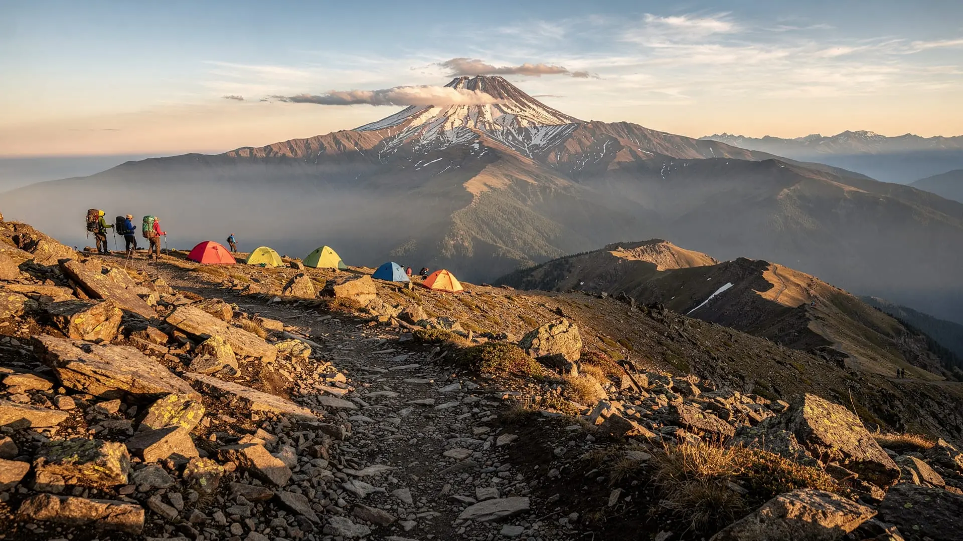
From the Lake Kari parking area, face the caldera rim to your south-west. The path is immediately obvious — a wide, well-worn track on thin alpine soil between frost-weathered basalt boulders. In late June the ground beside the path still holds snow patches; by July it is almost entirely bare.
The first 2 km gain elevation gradually on a wide plateau. The walking is easy here — ground is mostly firm, views open up behind you to the caldera and the reflection of sky in Lake Kari below. This is the best section to let your breathing settle and assess how altitude is affecting you.
At roughly 3500m the path steepens. The character of the terrain changes: the firm soil gives way to loose, volcanic scree — dark grey basalt fragments that shift underfoot. Trekking poles are valuable here. The path remains clear but you will need to pick your line carefully to avoid sliding backward on steeper patches.
The final 300m of ascent leads to the south summit ridge. Once on the ridge, the drop into the caldera becomes visible to your right (north) — a severe, beautiful void that makes the surrounding views suddenly make sense. The actual highest point is marked by a small cairn and, usually in summer, a group of hikers clustered around it.
What you see from the top
On a clear day, the panorama is staggering. To the north, the three higher Aragats peaks frame the caldera’s inner bowl. To the south, the Araratian plain stretches to the Turkish border — and on the clearest days (more likely in April-May and September than in hazy August) the twin cones of Ararat itself appear above the horizon, beyond the closed border. To the east, Lake Sevan is sometimes visible as a shimmer of blue on the horizon. To the west, the Aragatsotn highlands roll away toward the Akhurian river valley.
The altitude question: what beginners need to know
At 3879m, the summit is well above the threshold where altitude effects are felt. Most visitors arriving from sea level or Yerevan (900m) will experience some degree of breathlessness, headache, or slowed pace, particularly in the upper section. This is normal at altitude and not a reason to turn back unless symptoms worsen.
Signs that mean you should descend immediately: severe headache, vomiting, loss of coordination, confusion. These indicate altitude sickness and require descent without delay.
Things that help: start well hydrated (drink water the night before and the morning of the hike), sleep one night in Byurakan or at the lake before climbing, walk slowly in the upper section, and avoid alcohol the night before.
Children aged 10–14 with good fitness levels have summited the southern peak without difficulty. Very young children (under 10) and elderly hikers with any cardiovascular conditions should consult a doctor before attempting.
Guided ascents
The private Aragats southern summit hike from Yerevan is the most popular guided option for this specific peak. The tour collects participants from Yerevan, drives to Lake Kari, and provides a local guide who knows the exact line through the scree, the timing needed to summit before afternoon weather builds, and what to do if any participant needs to turn back early.
For hikers interested in attempting the more challenging northern summit eventually, the guided northern summit tour gives a sense of how the two peaks compare — the northern summit is in an entirely different category of commitment and requires technical preparation.
Before you go: essential preparation
Fitness benchmark
You don’t need to be a runner or a regular mountaineer, but you do need a baseline of aerobic fitness. A useful benchmark: if you can comfortably walk 15 km on flat ground or hike for 5 hours with a light pack, you will likely manage the southern summit on a good day. If you struggle with steep staircase climbs or feel winded at altitude in other contexts, spend more time acclimatising and consider hiring a guide.
Weather check
Aragats weather is variable and changes faster than forecast. The general rule: mornings are stable, afternoons develop convective clouds and sometimes thunderstorms. Never start a summit attempt after 10am. Check the Armenian weather service (meteo.am) the day before for upper-level forecasts.
What to bring
Complete gear list at the Armenia trekking gear checklist. For the southern summit specifically:
- Waterproof jacket (mandatory even in summer)
- Warm mid-layer (fleece or down vest — temperature on the summit can be 10°C below the lake even in July)
- Sun protection: sunscreen SPF50, sunglasses, hat
- 2+ litres water (no water source on the upper mountain)
- Snacks with quick-release energy (dates, nuts, bars)
- Trekking poles (strongly recommended for scree descent)
- First aid kit including ibuprofen and altitude-headache management
Getting to Lake Kari
By car: From Yerevan, drive north on the M3 toward Aparan (about 60 km), then follow the road through Byurakan toward Mount Aragats. The final 12 km to Lake Kari is rough and unpaved; a standard car can make it in dry conditions but a high-clearance vehicle is more comfortable. Total drive time: 1h 30min.
Without a car: Take a marshrutka from Yerevan’s Kilikia station to Aparan (about 1h, 500 AMD). From Aparan, a negotiated taxi to Lake Kari costs 6,000–8,000 AMD one-way. Arrange the return taxi in advance — there are no taxis waiting at the lake.
By tour: The simplest option. Most day tours from Yerevan to Aragats include Lake Kari access, guide, and transport. This also gives you a fallback if road conditions are unexpected.
Timing your visit in the season
Mid-June to mid-July: Lake Kari road has just opened; snow may still cover parts of the upper trail. Expect solitude, cold temperatures, and spectacular snowmelt. Navigation can be harder in this window.
Late July to August: Peak season. The trail is fully clear, well-trodden, and busy on weekends. Afternoon thunderstorms are more frequent — start by 6am to be off the summit by noon.
September: Excellent. Cooler temperatures, fewer crowds, clearer skies after summer haze clears. The caldera rocks begin to show autumn frost patterns. Highly recommended.
Early October: The road to Lake Kari may close depending on early snowfall. Call ahead or check local conditions. Possible but requires flexibility.
After the summit: combining with other Aragatsotn sites
Most hikers arrive at Aragats on a long day trip from Yerevan that combines the summit with other nearby sites. The most popular combination: stop at Amberd fortress on the way up (at 2300m, it takes only 45 minutes to visit) and then continue to Lake Kari for the hike. Alternatively, call in at Hovhannavank monastery and Saghmosavank on the way back to Yerevan — both monasteries sit in the Kasakh gorge, barely 40 minutes’ drive from Aparan.
The day trip from Yerevan to Aragats and Amberd combines both stops efficiently.
Frequently asked questions about the Aragats southern summit
How cold is it on the summit in July?
Summit temperature in July is typically 5–12°C, compared to 20–25°C on the Araratian plain below. Wind chill can push the effective temperature lower. A fleece mid-layer and windproof jacket are necessary regardless of how warm it looks when you leave Yerevan.
Is there a fee to hike on Aragats?
There is no formal entry fee or permit for hiking on Mount Aragats. The Lake Kari parking area may have an informal collection (around 500 AMD) from the café staff. No official charge exists for the summit route.
Can I camp at Lake Kari?
Informal camping is tolerated in the Lake Kari area. There are no designated pitches or facilities beyond the basic café. Bring a tent that handles low temperatures and wind; nights at 3200m can be below freezing even in August. The When to hike in Armenia guide includes notes on night camping at altitude.
What if I turn back early?
Turning back is always the right decision if you feel unwell, weather deteriorates, or time runs short. The caldera rim at 3400–3500m (before the final steep section) still offers tremendous views and is a perfectly valid endpoint for a day at Aragats. Don’t let summit pressure override good judgment.
How do the other Aragats peaks compare?
The southern summit is the gentlest introduction. The east peak (3916m) is similar in character but longer. The west (4080m) involves harder terrain and a full day. The north (4090m) is a technical mountaineering objective. The full four-peaks guide compares all four in detail.
The experience: what summiting Aragats actually feels like
Descriptions of mountain hikes sometimes emphasise only the physical — the kilometres, the gradient, the time. The less quantifiable part is also worth addressing, because the Aragats southern summit has a particular quality of experience that many visitors describe as unexpectedly affecting.
The lower third of the ascent is familiar mountain hiking: a clear path, increasing views behind you, the pleasant rhythm of uphill walking on a fine morning. The transition through 3400m brings the first change — the air is noticeably thinner, you are breathing faster than the walking pace would normally require, and the path ahead looks deceptively close. You are also above most of the clouds that form over the Araratian plain below, which gives the curious sensation of being elevated above normal weather.
The scree section focuses attention downward. The mind quiets during the step-by-step negotiation of loose basalt fragments. The upper ridge arrives with surprise — and the sudden view into the caldera is always a shock, regardless of how many photographs you have seen in advance. The scale of the bowl below, with the other three peaks framing the sky, is not something a screen prepares you for.
The summit cairn is usually surrounded by a small group of hikers eating, photographing, calling family members on the phone. The shared achievement and the altitude create an easy sociability — strangers exchange food, take each other’s photographs, point at features on the horizon. On the descent, your legs will know they have done real work, and the café at Lake Kari will produce the most deserved cup of tea of your trip.
What makes a good summit day
The difference between a good summit day and a difficult one often comes down to three factors: start time, weather, and company.
Start time: Leave Yerevan no later than 6am. This gets you to Lake Kari by 7:30am and on the trail by 8am at the latest. You should be on the summit by 11am and back at the lake by 1pm — safely ahead of the afternoon weather window. Late starters who reach the summit at 2pm face two problems simultaneously: deteriorating weather and tired legs for the descent.
Weather: Check the forecast the evening before. A clean anticyclonic forecast (high pressure, stable air) gives the most reliable summit day. If the forecast shows showers developing from mid-afternoon, start even earlier. A persistent low-pressure system with cloud below 3000m is a reason to postpone — the upper caldera in thick cloud is disorienting and the summit views are non-existent.
Company: A summit partner makes the day more enjoyable and significantly safer. If you don’t know anyone else planning the climb, ask at your Yerevan accommodation — guest house common rooms often produce trail partners. Alternatively, a guided tour assembles a group for you.
After the summit: celebrating in Yerevan
Arriving back in Yerevan after a successful Aragats summit, you will have covered something like 18–20 km in total movement and gained and lost 2700m of altitude from Yerevan’s level. This warrants a proper celebration.
The Lavash restaurant on Tumanyan Street is a perennial favourite for post-mountain eating: generous portions of traditional Armenian food (tolma, khorovats, freshly baked lavash bread) in a cave-like dining room that feels appropriately earthy after a day on volcanic rock. Alternatively, the Cascade Complex terrace restaurants offer a more relaxed ambiance with views of the city. A glass of Areni Noir, Armenia’s signature red wine, completes the day’s geography beautifully — you have been on Armenia’s highest accessible mountain and are now drinking wine made from grapes that grew at the mountain’s foot.