Mount Ararat: viewing the sacred mountain from Armenia
Armenia’s most defining view
There is a strange, beautiful tension at the heart of Armenian national identity: the country’s most sacred mountain, the mountain that appears on the national coat of arms and defines the visual imagination of every Armenian, is located in a foreign country behind a closed border.
Mount Ararat — Masis in Armenian, Agri Dagi in Turkish — stands at 5137m on Turkish territory. It became part of Turkey in 1920, under the Treaty of Kars signed between the Grand National Assembly of Turkey and the Soviet Union. That treaty ceded the region to Turkey at a moment when the Armenian state, exhausted and devastated, had no power to resist. For Armenians, the loss was catastrophic: not only had the massacres of 1915 destroyed the majority of the population of eastern Anatolia, but the mountain they considered the centre of their world was now in another country.
The border between Armenia and Turkey has been closed since 1993 — a consequence of Turkey’s support for Azerbaijan during the Nagorno-Karabakh conflict. There is currently no border crossing and no overland route between the two countries. Ararat is visible from Armenia; it is not reachable from Armenia.
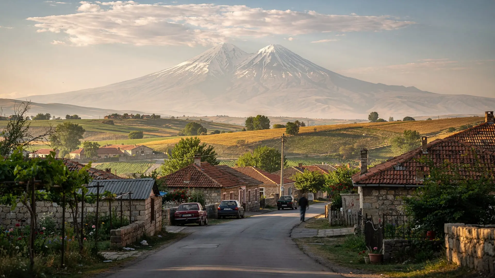
Understanding this context transforms what might otherwise be a simple tourist viewpoint into something much more emotionally complex. When Armenians look at Ararat from Khor Virap or from the terraces of Yerevan, they are not simply admiring a mountain. They are looking at a wound.
The best viewpoints from the Armenian side
Khor Virap monastery
The definitive Ararat viewpoint. Khor Virap monastery sits 35 km south of Yerevan on the edge of the Araratian plain, barely 15 km from the Turkish border. On clear days — most likely in spring (April–May) and autumn (September–October) — the two peaks of Ararat (Great Ararat, 5137m, and Little Ararat, 3896m) dominate the southern horizon, rising without foothills from the flat plain in a display of mountain form that is genuinely breathtaking.
The monastery itself is one of Armenia’s most historically significant sites: it was here that Gregory the Illuminator was imprisoned in a deep pit by King Trdat III for 13 years before being released and converting the king — and thus all of Armenia — to Christianity in 301 AD. The pit (khor virap means “deep dungeon” in Armenian) is still accessible and visitors can descend via a steep iron ladder.
The combination of extraordinary mountain view and extraordinary religious history makes Khor Virap the single most visited daytrip destination from Yerevan.
Practical note: Ararat is visible from Khor Virap on perhaps 60–70% of days. In summer, morning haze from the Araratian plain often obscures the mountain — the view is most reliable in early morning (before 9am) and in autumn and spring when atmospheric clarity is highest. Don’t be surprised if the mountain is invisible on your visit; this is common, especially in July and August.
Getting there: 35 km from Yerevan, 50 minutes by car. Marshrutkas toward Artashat pass the Khor Virap junction; from there, a 3 km walk or a short taxi. Alternatively, all Yerevan day-tour operators include Khor Virap.
Yerevan and the Cascade Complex
Ararat is visible from many parts of Yerevan on clear days. The best urban viewpoint is from the upper terraces of the Cascade Complex — the massive Soviet-era stairway-gallery that climbs the northern slopes of the city. From the Cascade roof, on clear days, both peaks of Ararat sit perfectly framed between the buildings to the south.
The roof of the Matenadaran manuscript museum, the terraces above Republic Square on clear evenings, and the Victory Park viewpoint (Tsitsernakaberd area) all offer good Ararat views from the city. In winter after heavy snowfall, when the air is crystal-clear, Ararat from Yerevan can appear close enough to touch.
From the summit of Aragats
The Aragats southern summit at 3879m offers one of the most encompassing views of Ararat available from Armenian territory. From this altitude, the mountain appears in its full three-dimensional form — you can see both the Great Ararat cone and Little Ararat to its side, set above the curvature of the Araratian plain. This elevated perspective, available only to those who make the hiking effort, is qualitatively different from the flat-plain view at Khor Virap.
The best time for an Ararat view from Aragats is early morning in September, when visibility is at its autumn maximum and the lower humidity reduces haze.
Viewing conditions and the weather factor
The single biggest practical issue for Ararat views is atmospheric haze. The mountain sits above the low-lying Araratian plain, which generates significant haze in summer from agricultural activity, dust, and moisture. The most reliable view conditions are:
- April–May: excellent. Post-winter air clarity is highest. Snow on Ararat is at maximum extent, making the mountain visually dramatic. Morning light from Khor Virap is outstanding.
- September–October: second-best. Autumn clarity approaches spring levels after summer haze disperses.
- July–August: least reliable. Haze is heaviest. Ararat may be invisible from Khor Virap for days at a time.
- December–February: exceptional clarity on clear winter days, but the drive to Khor Virap can be difficult in snow.
There is an honest trap here that tour operators sometimes do not disclose: tours sold as “Khor Virap with Ararat views” cannot guarantee the mountain will be visible. The Khor Virap monastery guide has more detail on managing expectations.
Ararat in Armenian culture
The mountain’s centrality in Armenian national identity cannot be overstated. It appears on:
- The national coat of arms (where it sits in the centre, surrounded by the symbols of medieval Armenian kingdoms, topped by Noah’s Ark — the biblical connection to Mount Ararat)
- The label of Ararat brandy, Armenia’s most exported product
- Countless paintings, poems, and folk songs
When the Soviet Armenian coat of arms first included Ararat (in 1921), Turkey officially protested to the Soviet Union that Armenia had placed a Turkish mountain on its national symbol. The Soviet foreign minister reportedly responded: “You have a crescent moon on your flag, and no one claims Turkey owns the moon.”
The mountain’s loss in 1920 is inseparable from the trauma of the 1915 Genocide — two catastrophic events compressed within five years that defined modern Armenian identity. For the diaspora especially, Ararat is the mountain you can see in your dreams but never quite reach.
Why Ararat climbing is a Turkey-side operation
Ararat climbs are organised from the Turkish town of Dogubayazit, on the eastern edge of Turkey near the Iranian border. The mountain is in Turkish Agri province, and climbing requires a Turkish permit (obtainable through licensed operators in Dogubayazit or Erzurum). The standard route (Southern Route) takes 3–4 days for the summit from base camp.
This guide is about viewing Ararat from Armenia — not about climbing it. If you are interested in the summit attempt, you will be planning a separate Turkey trip, entering through Istanbul or Erzurum. The Armenia–Turkey border is not open and there is no prospect of it opening in the near term given the ongoing political relationship.
Organised viewpoint tours from Yerevan
Day tours from Yerevan to the Aragatsotn region often offer clear Ararat views en route, particularly on the sections of the M3 highway north of Yerevan where the mountain is visible to the south.
For the primary Khor Virap experience, most Yerevan day tours incorporate the monastery into a southern Armenia itinerary combining it with Noravank monastery and sometimes Areni wine.
Connecting the Ararat narrative to a wider Armenia trip
The Ararat question is inseparable from Armenian history, and that history runs through the Tsitsernakaberd Genocide Memorial in Yerevan — the most visited memorial in the country. The heritage trip guide for diaspora visitors addresses the emotional weight that many Armenian-Americans and diaspora Armenians carry when they first see Ararat.
For the pure landscape context, the Armenia volcanic landscapes guide explains how Ararat’s volcanic geology relates to the other great Armenian mountains — Aragats, Azhdahak, and the Geghama range.
Frequently asked questions about Mount Ararat
Is Ararat visible from Yerevan every day?
No. Ararat is visible from Yerevan on perhaps half of all days, depending on season and atmospheric conditions. Spring and autumn offer the clearest views. In July and August, haze often obscures the mountain for extended periods. Check the webcam at Khor Virap (available on some Armenian weather sites) for current conditions.
Why is Ararat on the Armenian coat of arms if it is in Turkey?
The coat of arms was first adopted in 1918 by the First Republic of Armenia when Ararat was within the disputed zone between Armenian and Turkish control. When Armenia was incorporated into the Soviet Union in 1921, the coat of arms retained Ararat as a symbol of national aspiration despite the mountain being ceded to Turkey under the Treaty of Kars that same year. The symbol has persisted through Soviet times and into the independent Republic.
Could the Armenia-Turkey border reopen?
The border has been closed since 1993. There have been periodic diplomatic signals of possible normalisation, but the border remains closed in 2026. Any crossing between Turkey and Armenia currently requires flying through a third country.
Is climbing Ararat from Turkey safe?
Ararat climbs from Turkey are considered safe during the permit season (June–September). The mountain requires no technical climbing on the standard route but reaches 5137m — altitude sickness is the main risk. Turkish permit requirements have varied over the years and may require advance planning through licensed operators.
What is the difference between Great Ararat and Little Ararat?
Great Ararat (5137m) is the main volcanic summit — the massif you see prominently from Khor Virap and Yerevan. Little Ararat (Sis in Armenian, 3896m) is a secondary cone attached to the main massif to the south-east. Together they form the double-peaked profile that defines the mountain’s silhouette. Both peaks are on Turkish territory.
Is there an Armenian name for Mount Ararat?
The mountain is called Masis in Armenian — specifically, Great Masis (Mets Masis) for the main summit and Little Masis (Pokr Masis) for the secondary peak. Ararat is the name used in the biblical Genesis narrative and has become the international standard, but within Armenian language and culture, Masis is equally or more commonly used.
Visiting Khor Virap: practical guide
Getting there
Khor Virap monastery is 35 km south of Yerevan in Ararat province, near the village of Lusarat. The drive from Yerevan takes 50 minutes. From Yerevan, take the H1 highway south toward Artashat; after Artashat follow signs for Khor Virap (the road runs through agricultural flatland toward the monastery on the horizon).
By car: The most practical option for independent visitors. Parking is available at the monastery.
By marshrutka + walk: Take a marshrutka from Yerevan toward Artashat (Kilikia station, 45 min, 400–500 AMD); ask to be dropped at the Khor Virap junction on the main road. From the junction, it is 3 km to the monastery on a flat road — walkable in 40 minutes or a short taxi.
Organised tour: Every Yerevan day-tour operator offers Khor Virap, usually combined with Noravank (1.5h further south) and sometimes Areni winery. This is the most popular single-day itinerary from Yerevan. The Khor Virap and Noravank day trip guide covers the combination in detail.
The monastery
Khor Virap monastery complex includes the main Church of the Holy Mother of God (built 1662) and the older Chapel of Saint Gregory the Illuminator (7th century), built over the pit where Gregory was imprisoned. The descent into the pit is via a steep metal ladder — claustrophobic but an extraordinary experience. The underground chamber is authentic: Gregory was kept here for 13 years by King Trdat III before the miraculous healing of the king (after his transformation into a boar in the legend) led to Gregory’s release and the king’s conversion.
The monastery is an active Armenian Apostolic institution. Services are held; candles burn; incense lingers in the small chapels. The contrast between the intense religious life inside the walls and the spectacular secular landscape outside — Ararat filling the entire southern horizon — is genuinely striking.
Photography at Khor Virap
Khor Virap is one of the most photographed sites in Armenia, and for excellent reason. The composition — monastery bell tower in the foreground, Ararat filling the background — is iconic. Tips for better-than-postcard images:
Avoid high summer noon: The harsh midday light flattens the monastery walls and creates heat haze over Ararat. Best times: sunrise (extraordinary in late September, when Ararat appears in pink early light above the monastery silhouette), late afternoon (warm directional light on the stone walls), and blue hour (the monastery is sometimes lit at night in summer).
Use the agricultural landscape: The fields of the Araratian plain — wheat in May-June, sunflowers in July-August, bare in autumn — can add foreground interest that pure monastery-and-mountain shots lack.
Position for both peaks: Little Ararat (3896m) and Great Ararat (5137m) need to both be visible in frame for the classic composition. From the monastery forecourt, both peaks are visible to the south on clear days. Move west (along the outside of the monastery wall) to separate the two peaks slightly in your frame.
Ararat in modern Armenian geopolitics
The Ararat question is not merely symbolic or historical — it has active geopolitical dimensions. Turkey and Armenia have no diplomatic relations and no open border. Normalisation talks have occurred periodically since 2008 but have not resulted in any opening as of 2026. The border closure is technically linked to Turkey’s alliance with Azerbaijan and the Nagorno-Karabakh conflict, but deeper historical issues (Turkish non-recognition of the 1915 Genocide as genocide) make the path to normalisation complex.
The symbolic weight of Ararat in Armenian national identity — combined with the fact that it sits in Turkey — means any discussion of Armenian-Turkish relations inevitably involves the mountain. It appears in both countries’ political rhetoric: in Turkey, some politicians have periodically expressed resentment at Armenia’s use of Ararat as a national symbol; in Armenia, the mountain represents both loss and aspiration.
For foreign visitors, understanding this political background transforms Khor Virap from a picturesque monastery with a mountain backdrop into a site of complex contemporary meaning.
The Araratian plain: the context for the view
The flat, agricultural land between Yerevan and Khor Virap is the Araratian plain — the most productive and historically significant territory in Armenia, watered by the Araks and Hrazdan rivers. The Armenian heartland for thousands of years, this plain was the site of ancient Urartu’s capital (Tushpa, now Van in Turkey), of the Artaxiad and Arsacid capitals, and of the early medieval kingdom.
Today the plain is intensively farmed: vineyards (Ararat brandy production uses grapes from these fields), orchards, grain. On a clear autumn day driving to Khor Virap, with Ararat rising above the harvest fields and the Geghama range glowing amber behind you, the agricultural prosperity of the plain and the sacred mountain at its southern edge create a landscape that explains why this valley has been the centre of Armenian life for five millennia.