The Transcaucasian Trail in Armenia: a complete planner
A work-in-progress trail with world-class potential
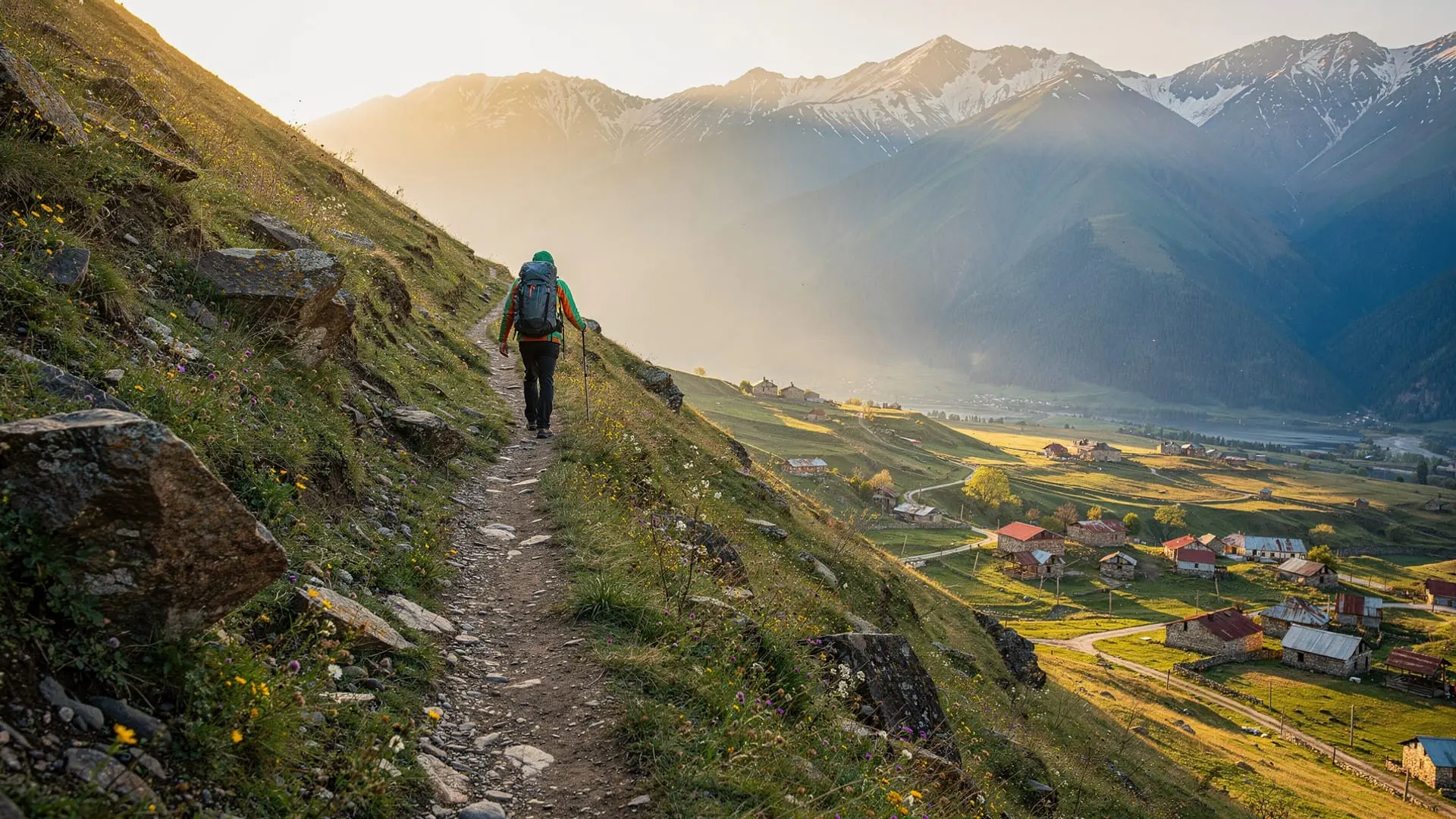
The Transcaucasian Trail (TCT) is one of the most ambitious long-distance hiking projects in the world: a continuous footpath from the Black Sea coast of Georgia to the Caspian coast of Azerbaijan, traversing the full breadth of the Caucasus mountains. Armenia’s share of the route — roughly 830 km when fully built — slices through the country’s most biodiverse and least-visited landscapes, from the forested ridges of Tavush in the north-east to the volcanic plateaux of Syunik in the south.
The honest caveat: as of spring 2026, the TCT in Armenia is a trail under construction. Some sections are impeccably waymarked with the characteristic white-red-white TCT blazes; others are rough GPS tracks requiring confident navigation. That unfinished quality is actually part of the appeal for many hikers — this is trail-building in real time, and visitors who walk it now are genuinely helping shape the route.
For up-to-date trail conditions, section-by-section maps, and volunteer opportunities, the definitive source is transcaucasiantrail.org.
The three main segments
Tavush section (north-east)
The Tavush segment is arguably the most developed and walkable stretch of the Armenian TCT. It passes through dense beech and oak forests, following ridgelines above the Aghstev river valley. Dilijan National Park sits at the western end, and the trail connects several villages that are otherwise barely visited. Expect oak glades, wildflower meadows in late spring, and the moist micro-climate that earns this region its nickname “Armenian Switzerland.” Sections near Dilijan and onward to Ijevan and Yenokavan have been substantially cleared and marked.
Practical note: Dilijan town makes an excellent base for the Tavush section. The Hotel Old Dilijan Complex (renovated Soviet sanatorium, excellent food) and several guesthouses all sit within walking distance of trailheads.
Lori section (north)
The Lori segment crosses higher, more open terrain, traversing meadows above the tree line and dropping into the gorges that hide Haghpat and Sanahin monasteries. This section connects the TCT to some of Armenia’s most celebrated UNESCO World Heritage sites without making the monasteries a tourist box-tick — you arrive on foot, with genuine effort behind you.
The Lori segment rewards hikers who take their time. Side trails dip into the copper-mining town of Alaverdi and continue toward the Georgian border via Bagratashen, creating a natural cross-border continuation for those walking the full Caucasus route. Tufenkian Avan Dzoraget Hotel near Alaverdi is the most comfortable base in this area.
Syunik section (south)
The southern stretch is the wildest and most challenging. The TCT here climbs over the Zangezur range — 3,000+ m passes, permanent snowfields until July, and genuine remoteness. The trail connects to the small city of Kapan, passes near the Khustup massif, and continues toward the Iranian border. This section requires more self-sufficiency: camping is essential for multi-day stages, and there are long gaps between villages.
Syunik’s TCT alignment also skirts the southern shore of Lake Sevan and crosses the Geghama volcanic range — landscapes that feel pre-human, volcanic, and vast.
Logistics: getting on and off the trail
Getting to Dilijan (north entry point): Marshrutkas from Yerevan’s Kilikia bus station run frequently (95 km, about 1h 45min, ~1,000 AMD). Taxis and GG Taxi are an option but pricey for solo travellers.
Getting to Kapan (south): Kapan is 4+ hours from Yerevan by shared taxi or marshrutka. Several operators offer direct transport; plan an overnight there rather than trying to do it as a day trip.
Resupply: Dilijan and Ijevan have supermarkets. Villages en route often have small shops, but supplies are basic. Carry at least 2 days of food for most Tavush segments and 3–4 days for Syunik stages.
Accommodation: A network of TCT guesthouses (marked on the trail website) charges around 5,000–8,000 AMD for a bed and sometimes a meal. Camping is generally tolerated on public land; avoid camping in national park core zones without permits.
Water: Streams are frequent in Tavush and Lori; less so in Syunik’s high plateaux. Treat all water (tablets or filter) as a precaution.
Guided options for the TCT
Joining an organised hike for your first TCT section is a smart way to learn the terrain before attempting it independently.
The 5-day private hiking & cultural tour from Yerevan covers key landscapes along the TCT corridor, including Dilijan National Park and Lori highlands — a practical introduction to northern Armenian trail terrain without the navigation pressure of a solo thru-hike.
For birdwatchers and naturalists combining trail hiking with wildlife observation, this 3-day bird-watching and hiking tour explores forest corridors that overlap with the Tavush TCT segment, where raptors and rare Caucasian species concentrate in the canopy above the trail.
Season by season
April–May: Low-altitude Tavush sections are walkable; Lori emerges from mud. High Syunik passes remain snowbound. Wildflowers peak in late May. Best for northern segments.
June–July: The ideal TCT window. Snow is mostly gone except on Aragats and the highest Zangezur passes (linger until early July on north-facing slopes). Long days, warm evenings, wildflowers at altitude.
August: Peak summer; Tavush is hot and humid at lower elevations. Move early in the day. Syunik is excellent — dry, warm, clear.
September: Arguably the best month overall. Temperatures ease, forests begin to colour (Tavush beech turns gold from late September), crowds thin.
October: Lori and Tavush are stunning in autumn colour but expect mud and early frost on high sections. Check trail updates before heading south.
November–March: Syunik passes are impassable. Tavush low sections remain walkable in decent winter gear but days are short and guesthouses may be closed.
What to bring for a TCT section
Standard mountain hiking kit applies: waterproofs (even in summer — the Tavush forest creates its own rain), trail shoes or lightweight boots, trekking poles for the steep gradients, a 30–40 L daypack for day sections or 60–70 L pack for multi-day stages. See the dedicated Armenia trekking gear checklist for a complete list with Armenia-specific notes.
A GPS device loaded with offline maps (maps.me or Gaia GPS with TCT overlay) is strongly recommended for any section beyond Dilijan. The trail website provides downloadable GPX files for each segment.
How the TCT fits into a broader Armenia trip
Most visitors incorporate one or two TCT day sections into a longer Armenia itinerary rather than attempting the full route. A popular combination: fly into Yerevan, spend two nights exploring the city, then head to Dilijan for two TCT walking days before returning south via Lake Sevan. This gives a genuine feel for the trail without a major logistical commitment.
Hikers who want to pair the TCT with a peak attempt can combine Tavush sections with the Mount Aragats four-peaks guide for a multi-week trip that hits both long-distance trail and high-altitude summit objectives. The Dilijan National Park hikes page covers the shorter day routes that complement the TCT’s Tavush segment.
For cross-border extensions, the TCT continues into Georgia — the route through Lori province connects naturally toward the Bagratashen border crossing. See our Yerevan to Tbilisi overland guide for practical cross-border logistics.
Day-by-day sample itinerary: Dilijan TCT section (4 days)
This is the most practical introduction to the Armenian TCT for visitors with limited time. It uses Dilijan as a base, covers the Tavush corridor’s best segments, and requires no specialist navigation skills.
Day 1 — Arrival and orientation: Travel from Yerevan to Dilijan (1h 45min by marshrutka). Check in to your accommodation (Hotel Old Dilijan Complex recommended). In the afternoon, walk the town forest Trail 1 from the national park visitor centre — a 5 km loop that acclimatises you to the terrain and gives views over the Aghstev valley. In the evening, explore Dilijan’s Old Town (a reconstructed 19th-century merchant district) and eat at one of the small khinkali or traditional Armenian restaurants on Sharambeyan Street.
Day 2 — Gosh to Lake Parz traverse (TCT Tavush section, 9 km): Taxi to Gosh village (20 min from Dilijan). Walk the forest ridge trail past Goshavank monastery to Lake Parz — a classic TCT day through old-growth beech, with occasional yellow Janapar blazes and the better-marked TCT white-red-white sections on the ridge. Arrange a taxi pick-up from the Lake Parz car park at the end of the day (or walk the 7 km back to Dilijan on the road).
Day 3 — Kirants monastery approach: This is a longer, more remote day. Taxi to the Aghstev valley road east of Dilijan. The trail follows the river before climbing through forest to Kirants monastery — a ruined 13th-century complex in an isolated canyon setting near the Georgian border. Allow 6–7h round trip. This day puts you on genuine TCT corridor terrain.
Day 4 — Rest and return: Morning at leisure in Dilijan; afternoon marshrutka back to Yerevan. Optional: stop at Lake Sevan en route (the marshrutka passes the lake).
Accommodation along the TCT
The guesthouse network is the infrastructure backbone of the Armenian TCT. The trail website maintains a current list of registered guesthouses; the following are the most reliable at the time of writing:
Dilijan and Tavush: Hotel Old Dilijan Complex (mid-range, excellent food, trail information); Tufenkian Old Dilijan Complex (boutique, higher price); several family guesthouses at 6,000–10,000 AMD per night including breakfast. Ijevan has additional options for hikers continuing east toward the Georgian border zone.
Lori province: Tufenkian Avan Dzoraget Hotel near Alaverdi (the premium option, genuinely exceptional); community guesthouses in Haghpat and Odzun villages at very affordable rates.
Syunik: Accommodation is sparse in the high sections. Kapan city has the Mirhav Hotel and several guesthouses for the Khustup approach. For the high-altitude TCT sections, wild camping is the primary option — bring a tent.
TCT vs Janapar: understanding the overlap
The Armenian TCT and the older Janapar Trail share significant corridor overlap in Tavush and Lori. In practice, you will encounter both trail marking systems (TCT’s white-red-white and Janapar’s yellow blazes) on some sections. The Janapar Trail complete guide explains the relationship in detail. For planning purposes: where both trails are documented, follow the TCT markings (more systematic and better GPS coverage). Where only Janapar blazes exist, use them alongside your GPS track.
Supporting the trail
The Transcaucasian Trail Association is a non-profit and accepts trail-building volunteers as well as donations. If you walk a TCT section, filing trail condition reports on the official website actively improves the maps for future hikers. Several guided operators also contribute a portion of booking fees to trail maintenance — worth checking when choosing a tour.
Trail-building volunteer camps are held annually in Armenia (typically in spring and autumn). Participants work for one to two weeks clearing trail, installing markers, and documenting conditions. No trail experience is required — only a reasonable level of fitness and a willingness to do physical work. Details at transcaucasiantrail.org under “Volunteering.”
Frequently asked questions about the Transcaucasian Trail in Armenia
Is the entire Armenian TCT section walkable in 2026?
No. Approximately half the planned 830 km route is cleared, marked, and documented with reliable GPS data. The most reliable segments are in Tavush (Dilijan/Ijevan area) and parts of Lori. The Syunik high-altitude sections require strong navigation skills and prior mountain experience. Always check transcaucasiantrail.org for current conditions before any section.
Do I need a permit to hike the TCT in Armenia?
No general permit is required. Dilijan National Park has entry fees (around 1,000 AMD per person) but no specific trail permit. Some areas near the Iranian border in southern Syunik require advance registration with local authorities — the trail website flags these zones clearly.
Can I hike the TCT solo?
Yes, experienced hikers can and do hike TCT sections solo. For Tavush day sections, solo hiking is perfectly reasonable. For remote Syunik stages, a hiking partner, good maps, and emergency communication (satellite messenger recommended) reduce risk significantly. Local guides can be hired through community guesthouses at reasonable rates.
What is the best section for a first-time TCT hiker?
The Dilijan National Park corridor — specifically the section between Gosh village (near Goshavank monastery) and the trail network around Lake Parz — is the most established and visually rewarding entry point. Well-marked, comfortable distances, and excellent guesthouse infrastructure.
Are there bears or other dangerous wildlife on the TCT?
Brown bears are present in Tavush forests and occasionally in Lori. Encounters are rare but real — make noise on the trail, store food properly if camping, and carry bear spray if you have strong concerns. Wolves are present in Syunik. Neither species poses significant risk if you behave sensibly. Vipers (Armenian viper, Montivipera raddei) are more commonly encountered — watch where you step on rocky sections.
Can I combine the TCT with Lake Sevan?
Yes. The Gegharkunik segment of the TCT skirts the southern shore of Lake Sevan. From the shore, you can break off to visit Sevanavank monastery or catch a marshrutka back to Yerevan. This makes for an excellent 2–3 day loop combining trail hiking with lake views. See our Lake Sevan complete guide for accommodation options along the shore.
How do I get trail updates and current conditions?
The official source is transcaucasiantrail.org — the interactive map there shows which sections are cleared, marked, and photographically documented. The TCT Facebook group also has active trip reports from recent hikers and is responsive to condition questions.