Khor Virap with snow & Mount Ararat in February
The risk of going in February
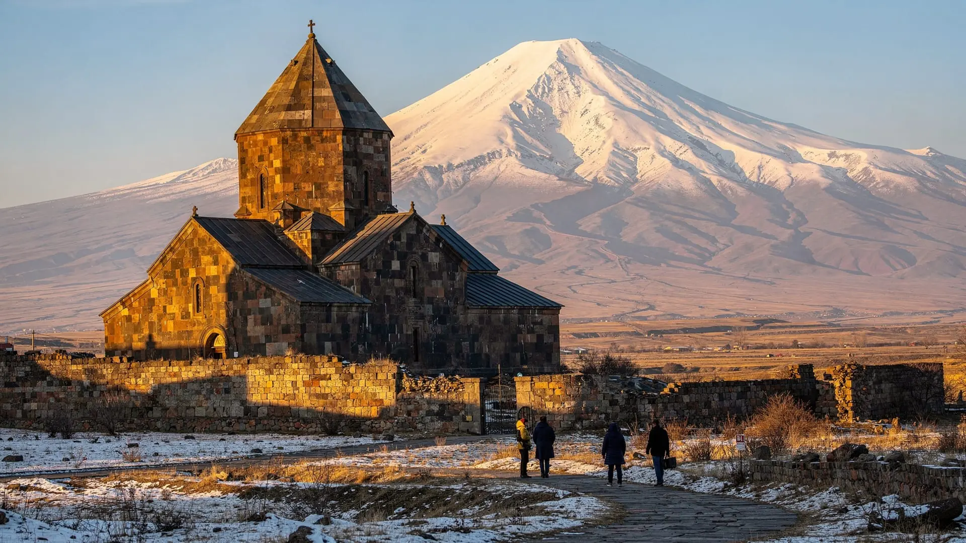
Every piece of travel writing about Khor Virap mentions the same thing: the view of Mount Ararat. The monastery sits on a hill rising from the Ararat plain, with nothing between it and the mountain — nothing man-made, and no terrain interruption. On a clear day, Ararat fills the southern horizon in a way that justifies every photograph you’ve seen of it. On a hazy day, which accounts for perhaps a third of summer visits, you see a pale shape or nothing at all.
February is not hazy. The north winds that come off the mountains in winter scour the sky. The temperature in the Ararat valley in February is typically -1 to 7°C — cold but not extreme, and the cold comes with compensation: visibility that summer cannot match. Ararat in winter, seen from Khor Virap, is the mountain at its most clear and most imposing.
I drove out on a Thursday morning, leaving Yerevan at 8 a.m. The road south through the Ararat valley runs through agricultural land — orchards, vineyards, small villages — that is dormant in February, everything stripped back to bare wood and brown earth. Snow had fallen two days before and was still present on the higher ground, including a thin covering on the lower slopes of Ararat visible far to the south. The plain itself was clear but cold.
The drive takes about 50 minutes from central Yerevan — 35 kilometres on a good road that empties of traffic once you’re past the city outskirts. I arrived at the monastery car park at 9 a.m. to find three other vehicles. One was a tour van whose passengers were already walking toward the monastery. The other two were locals who appeared to be there for reasons that weren’t tourism.
What you see first
The monastery is visible from the road as you approach — a cluster of stone buildings on a low hill, with the church dome rising above the outer wall and, behind it, Ararat in white. The photograph that everyone takes is the obvious one: monastery in foreground, mountain behind, flat plain between them. In February snow, with the Ararat plain lightly frosted, the composition becomes something more specific: a wintery Central Asian landscape that could be a 17th-century painting.
I walked the path up the hill to the monastery gate. The path is short and well-maintained. The wind was cold and coming from the mountain, which felt appropriate. Inside the outer wall, the courtyard was quiet — the stone catching morning sun, the monastery cat (there is always a monastery cat) watching from a step.
The Church of the Holy Mother of God dates from the 17th century, though the site is far older. Its interior is dark, with oil lamps and candles providing most of the light. The frescoes on the walls are partly damaged and partly restored — some sections in the Soviet manner of restoration that prioritises legibility over age, others left in their original state of partial preservation. I prefer the latter.
The pit of Gregory
The name “Khor Virap” translates as “deep pit” in Armenian, and the pit in question is the central historical fact of the site. In the early fourth century, the Armenian king Tiridates III imprisoned Gregory the Illuminator — the man who would eventually convert him to Christianity and become the first head of the Armenian church — in an underground pit on this site. Gregory survived thirteen years of imprisonment before being released, converting the king, and presiding over the Christianisation of Armenia in 301 AD.
The pit is accessible to visitors via a narrow staircase that descends about six metres into the ground. At the bottom is a small, low chamber carved from the rock — damp, dark, remarkably claustrophobic. A votive lamp burns at one end. There are candles. The proportions of the space make it immediately clear that it was not designed for human comfort.
Going down requires ducking and then descending a nearly vertical ladder in stages. Coming back up requires the same in reverse. On the day I was there, a woman ahead of me in the queue descended, stayed for about forty-five seconds, and came back up looking as though she had made a decision she wouldn’t repeat. I stayed for several minutes, which was enough to feel the dimensions of the place and to understand, in a small physical way, what thirteen years here would have meant.
The chamber is venerated as a pilgrimage site. There are icons at the bottom and a record of visits in a notebook near the entrance. Several groups of Armenians were treating the descent with visible devotion — crossing themselves before going down, spending time in quiet prayer at the bottom, crossing themselves again on the way up. I moved aside to let the devotional visitors have space.
The view in winter
After the underground chamber, I went up to the top of the monastery wall to look at Ararat. The mountain is, from this angle, enormous. It occupies a huge portion of the southern horizon — not just the cone of Greater Ararat (5,137 metres) but the entire massif, including Little Ararat (3,896 metres) to its right. In summer haze, the mountain can look indistinct, as if it might not entirely exist. In February clarity, it is undeniably, definitively there.
There is a geographic irony to Khor Virap that no one visiting can avoid noticing: Ararat is in Turkey. The Armenian-Turkish border runs just 10 kilometres south of the monastery, and the mountain that defines Armenian national identity — the symbol on the national coat of arms, the image on the cognac label — is in a country whose border has been closed to Armenians since 1993. You can see Ararat from Khor Virap with perfect clarity and cannot go there.
I don’t mean to dwell on this. It’s simply the reality of the site and it’s visible in the landscape: the watchtower on the Turkish side of the border is visible with binoculars from the monastery wall. The mountain is there, enormous and beautiful and inaccessible. Most of the Armenian visitors I spoke to that morning looked at it with an expression I couldn’t fully read — not grief exactly, but something in that family.
The mountain in context
Standing at Khor Virap looking at Ararat, it’s easy to understand the mountain as simply a beautiful geographical feature. But the relationship between Armenia and Ararat is more complicated than that, and being at this particular vantage point makes the complexity immediate.
Ararat appears on the Armenian national coat of arms, surrounded by the national colours. It is the symbol most closely associated with the country internationally — even people who know little else about Armenia know the mountain. But the mountain is in Turkey. The Armenian-Turkish border, which has been closed since 1993, runs 10 kilometres south of where you’re standing.
The treaty that established the current border — the Treaty of Kars, 1921 — was negotiated between the Soviet Union and the new Turkish Republic under Mustafa Kemal Atatürk, over the heads of the Armenian people. Armenia, having just been absorbed into the Soviet sphere, had no say in the border decision. The mountain was given to Turkey; or, more precisely, recognised as falling within Turkey’s territory.
The Ottoman-period history that preceded this border decision — the 1915 genocide and the destruction of the Armenian communities of eastern Anatolia, which included Ararat’s surrounding region — means that the mountain’s location is experienced by Armenians not merely as a geopolitical reality but as a wound. The most sacred visible symbol of the national identity is in a country that officially denies the genocide and keeps its border closed.
I note this not to make the visit to Khor Virap a political act — it is a religious site with its own long history — but because the view demands context. The mountain is not simply beautiful. It is beautiful and complicated and heavy with a specific history.
Combining with Noravank
The usual combination for a day trip is Khor Virap and Noravank — south to the monastery, then east through the Ararat valley to the gorge country of Vayots Dzor and the red-cliff monastery above the river. The drive between them takes about an hour and fifteen minutes.
In February, Noravank presents a different character: the red tuff cliffs are darker in winter light, snow may be visible on the upper cliffs, and the monastery is completely empty of tour groups. I arrived at Noravank at 1 p.m. to find it entirely deserted, which has the double effect of allowing you to experience the architecture in silence and reminding you that the site has been here for nine centuries without caring whether you showed up.
The combination of the two in a single winter day is, I think, one of the better day trips available from Yerevan — not despite the cold and the off-season emptiness, but partly because of it. The light in February has a particular quality in the Ararat valley: low, clear, very directional. Everything looks slightly more serious than it does in summer.
For the full logistics and what to expect on arrival, the Khor Virap guide covers opening hours, the underground chamber access, and the best approach for the mountain view. One practical note: the monastery is free to enter, but a donation is appropriate and appreciated.