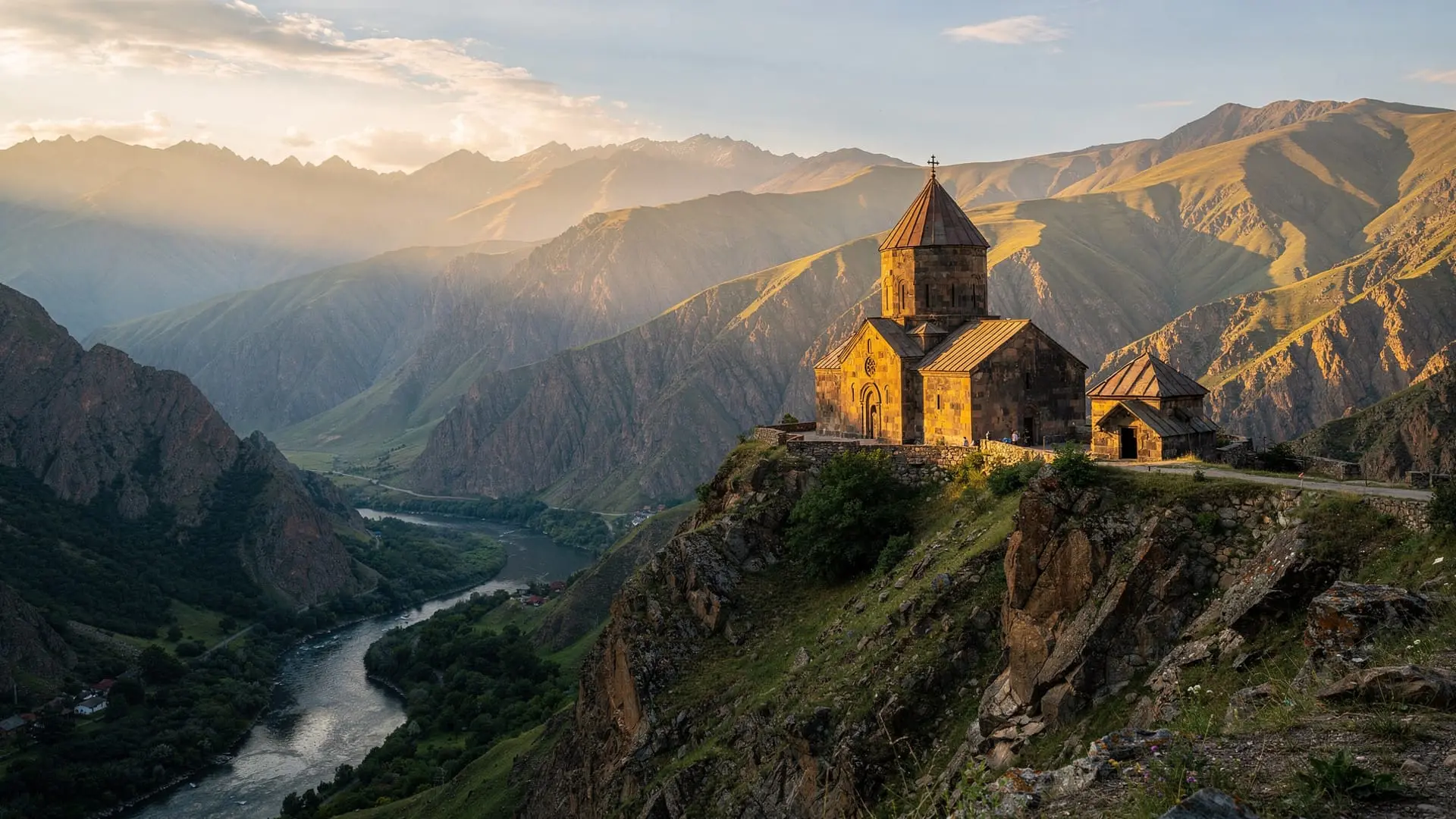
A medieval fortress at 2,300 metres
Amberd sits at the confluence of the Arkashen and Amberd rivers on the southwestern slopes of Mount Aragats, Armenia’s highest mountain massif. At 2,300 metres above sea level, it is one of the highest fortress complexes in the Caucasus — a windswept plateau position that made it both strategically commanding and brutally exposed to the elements.
| Where | Aragatsotn, southwestern slope of Mount Aragats, 55 km from Yerevan |
| Cost | Free entry, no ticket office |
| Time needed | 1.5–2 hours on site; half day with the drive |
| Getting there | Car or guided 4WD tour from Yerevan (~1 hour) |
| Best time | May–June (wildflowers) or Sep–Oct (stable weather); closed by snow Nov–Apr |
The fortress was built in the 11th century under the Pahlavid dynasty and later held by the Zakarids, who also controlled much of northern Armenia during the Georgian golden age. The adjacent Vahramashen Church, also called the Church of Amberd, dates from 1026 and is considerably better preserved than the fortress walls — its pink tuff stonework is nearly intact. The entire complex was sacked by the Mongols in 1236 and never fully recovered.
Today the ruins of the fortress walls, towers, and the intact church stand against a backdrop of high Aragatsotn meadows and the volcanic slopes above. On clear days — especially in spring before summer haze — the views extend south across the Ararat plain to Mount Ararat itself.
Getting there from Yerevan
By car: The most common approach is from Yerevan via the main Yerevan–Gyumri highway (M1) north, turning east toward Aparan and then following signs toward Byurakan and Amberd. Total distance is approximately 55 km; drive time is about 1 hour. The last 5 km of road is unpaved — gravel and rock — and is manageable in a standard saloon car in summer but requires care. A high-clearance vehicle is preferable.
Alternative route via Tsaghkadzor: Some drivers approach from the east via Tsaghkadzor and Aparan; this adds distance but the road is more varied.
By guided tour: Most Yerevan tour operators include Amberd in day trips that also cover the Armenian alphabet monument and often Lake Kari higher on Aragats. Tours typically use 4WD vehicles for the last section of road.
Note on access: In winter (November–April), the road to Amberd is often blocked by snow. Even in early May, snowdrifts can close the upper approach. Check conditions locally before attempting the drive.
What to see
Amberd fortress walls and towers
The fortress walls enclose an irregular quadrilateral of roughly 120 by 70 metres. Several towers remain partially standing, and the curtain walls — some sections reaching 3 metres in height — show the scale of what was once a substantial highland stronghold. There are no formal exhibits inside the walls; the experience is archaeological — walking the perimeter, reading the landscape, imagining the garrison that held this position against Mongol advance.
An underground cistern beneath the fortress floor is visible through an opening — a reminder that sieges at this altitude required self-sufficient water storage.
Vahramashen Church (Church of Amberd, 1026)
Standing just outside the fortress walls on the southern face, the Vahramashen Church is the highlight of the complex for most visitors. Built in 1026 by the Pahlavid prince Vahram II, it is a single-nave barrel-vaulted church with a distinctive gavit (narthex) and several fine khachkars (cross-stones) in the adjacent courtyard. The stonework is Armenian tuff — pink-orange — in excellent condition given its 1,000-year age and exposure.
The church is sometimes unlocked and actively used for small services. Even when closed, the exterior and courtyard khachkars are fully visible.
Mountain views and landscape
The plateau around Amberd gives views across the Aragatsotn highlands that are exceptional on clear days. The Aragats massif rises directly above to the north (the four Aragats summits reach 4,090 metres), and on very clear days — especially late spring before summer haze — Mount Ararat is visible to the south.
In late May and June, the surrounding meadows are carpeted in wildflowers: yellow, blue, and purple across the volcanic soil. This is arguably the best season to visit for sheer visual impact.
How long to spend
The fortress and church together take about 1.5–2 hours including a walk of the perimeter walls, the church interior, and time to appreciate the landscape. With the drive from Yerevan (1 hour each way) and a short walk, a half-day is the right allocation.
Combining Amberd with the Armenian alphabet monument (15 km further down the mountain toward Artashavan) adds another hour and rounds the day out significantly.
Combining with other sites
Armenian alphabet monument (15 km south toward Artashavan): The monument to the 39 letters of the Armenian alphabet is a 15-minute drive below Amberd on the way back from the mountain. The two sites are almost always visited together. See Armenian alphabet monument.
Saghmosavank monastery (25 km west): The 13th-century Saghmosavank monastery on the edge of the Kasakh gorge lies in the same general zone of Aragatsotn. With a car and an early start, Saghmosavank, Hovhannavank, Amberd, and the Alphabet Monument can all be covered in one full day.
Mount Aragats and Lake Kari (above Amberd): The road that passes Amberd continues higher up Aragats toward Lake Kari (3,200 m) and the base of the hiking routes to the four Aragats summits. If you have a 4WD vehicle, continuing beyond Amberd to Lake Kari adds spectacular high-altitude landscape to the day.
Byurakan observatory (20 km south): Byurakan observatory is on the lower slopes of the same Aragats approach road. A natural stop when combining the upper mountain sites.
Amberd vs the Aragatsotn day-trip alternatives
If you only have time for one Aragatsotn stop, here’s how the main options compare:
| Site | Draw | Effort | Good for |
|---|---|---|---|
| Amberd fortress | Fortress + church + mountain views | 4WD-friendly gravel road, moderate walking | History and scenery combined |
| Armenian alphabet monument | 39 stone letters, photogenic | Flat, paved, easy | Quick photo stop, families |
| Saghmosavank | Canyon-edge 13th-century monastery | Paved road, short walk | Architecture and gorge views |
| Mount Aragats (Lake Kari) | High-altitude lake, summit hikes | 4WD, cool even in summer | Hikers wanting more altitude |
Most itineraries pair Amberd with one or two of the others rather than choosing a single stop — see the Aragats and Amberd day trip guide for a full route.
Tours and tickets
Entry to the Amberd complex is free. There is no ticket office.
For a broader Aragatsotn day that includes the Alphabet Monument and Saghmosavank monastery: this Amberd, Alphabet Alley, and Saghmosavank day tour covers the three main Aragatsotn highlights with an English-speaking guide.
To add wine tasting to the mountain circuit: this Amberd fortress and wine tasting tour combines the high mountain site with a winery visit in the afternoon.
See the full Aragatsotn province guide for an overview of the region.
Practical tips
- Road conditions: the last 5 km to Amberd is unpaved — ask locally about current conditions, especially before May and after October
- 4WD recommended: a high-clearance vehicle makes the unpaved section much more comfortable; standard cars can manage in summer but with care
- Footwear: wear sturdy shoes for the fortress perimeter walk — the ground is rocky and uneven
- Wind: the plateau is exposed and windier than the valley below; bring a warm layer even in summer
- Photography: morning light (before 11:00) hits the church facade directly. Afternoon light is better for the mountain backdrop to the north
- Water and food: no facilities at the site; bring food and water from Yerevan or from Aparan on the way up
- Mobile coverage: patchy above 2,000 metres; download the route on Google Maps or a trail app before leaving Yerevan
- Cash: bring AMD — there are no card machines at Amberd or in Aparan’s smaller shops; see the Armenia currency and AMD guide for details
- Packing: layers matter more than at lower-altitude sites; check the Armenia packing list by season if you’re combining Amberd with a longer highland day
Frequently asked questions about Amberd fortress
Why is Amberd fortress so ruined compared to the church?
Fortresses were functional military structures regularly modified, damaged, and rebuilt. The Vahramashen Church, built as a permanent sacred structure with more careful stonework, survived better. The Mongol sack of 1236 destroyed most of the fortress infrastructure; the church, as a religious building, may have been spared deliberate destruction.
Can I visit Amberd without a 4WD vehicle?
In summer (June–September), a standard low-clearance car can usually manage the unpaved section with care. Spring (May) and autumn (October) require more caution. Avoid attempting it after rain, when the gravel section becomes muddy. In doubt, book a tour operator who uses appropriate vehicles.
Is there anything to eat at or near Amberd?
No. There are no cafés, restaurants, or shops at the fortress site. The nearest provisions are in Aparan (25 km below) or Byurakan. Bring everything you need from Yerevan.
How does Amberd compare to the better-known Armenian fortresses?
Amberd is less reconstructed than the sites in cities but more evocatively positioned than most. Its combination of an intact church, ruined fortress walls, and exceptional mountain scenery makes it distinctive — more atmospheric than many formally managed sites.
What is the best time of year to visit Amberd?
May and June for wildflowers and clear mountain views. September and October for golden light and stable weather. Summer (July–August) is fine but hazier and hotter on the drive up, though the plateau itself stays cool.
Is Amberd worth it if I’ve already seen other Armenian fortresses?
Yes — the combination of an intact 11th-century church, ruined fortress walls, and a genuinely dramatic mountain setting at 2,300 m is not replicated elsewhere in Armenia. Tatev and Khor Virap have their own distinct draws (cable car, Ararat views), but Amberd’s high-altitude fortress-and-church pairing is unique.