Armenia’s highest mountain — four summits, one exceptional day
Aragats is a dormant volcano with four summits and, at its Northern Summit (4,090 m), the highest point in the Republic of Armenia. It is also one of the most accessible 4,000-metre peaks in the Caucasus: a road penetrates to 3,200 metres at Lake Kari, leaving a hike of 900 vertical metres to the northern summit — achievable for fit, acclimatised adults in a single day.
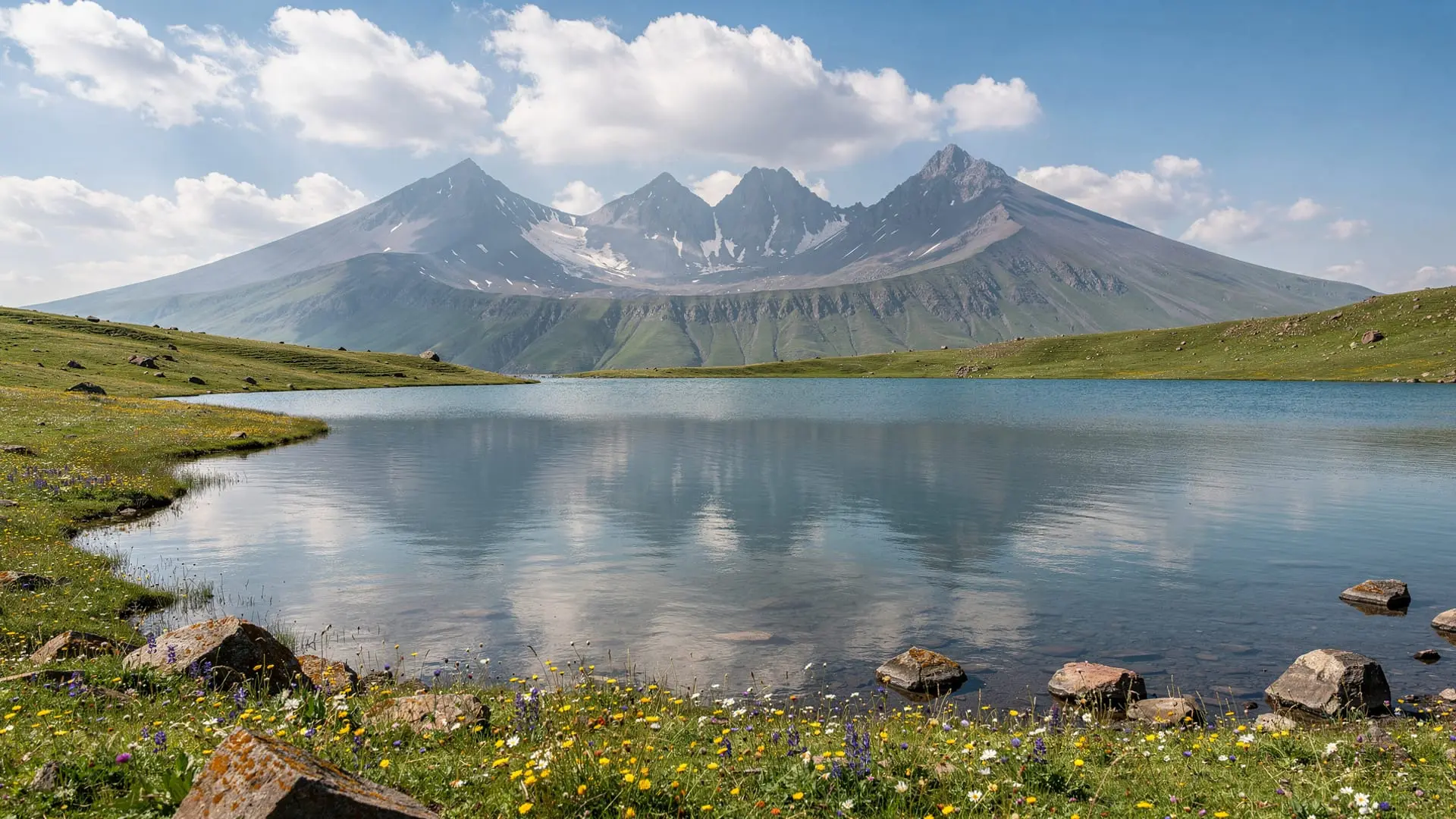
The mountain dominates the Aragatsotn province northwest of Yerevan. On clear days (most common in the morning hours), it is visible from the capital — a broad, multi-topped volcanic massif that is distinctly different in character from the sharp cone of Ararat (visible to the south). Where Ararat is a perfect volcanic cone, Aragats is a wide, rugged horseshoe of ridges around a caldera lake (Lake Kari), with four summits of varying difficulty at its rim.
Aragats offers something for every fitness level: the Southern Summit (3,879 m) is an easy 2-3 hour hike from Lake Kari; the Northern Summit (4,090 m) is a more serious all-day undertaking with some scrambling; and the base area around Amberd fortress and the wildflower meadows at 1,800–2,400 metres is accessible to anyone in a car.
Getting to Mount Aragats from Yerevan
By car: 60–70 km northwest of Yerevan depending on route. The main approach via Aparan and Aragats village reaches the Amberd fortress (2,300 m) and continues (rough road) toward Lake Kari (3,200 m). An alternative approach via Artashavan and the Byurakan-Ohanavan road also reaches the mountain. Drive time from Yerevan to Amberd: 1 hour 30 minutes on paved road. Lake Kari requires 4WD or high clearance from Amberd.
Road condition to Lake Kari: the road between Amberd and Lake Kari is unpaved and rough — high clearance recommended, 4WD preferred in early season (June) when snow patches may block sections. Check conditions locally before driving above Amberd.
By guided tour: most mountain tours from Yerevan include vehicle transport to Lake Kari and a guide for the summit hike. Highly recommended for first-timers who don’t know the route.
By marshrutka + taxi: Marshrutka to Aparan from Kilikia Station (Yerevan), then local taxi to Amberd or Lake Kari. Works but requires advance arrangement.
What to see and do on Mount Aragats
Amberd Fortress and Vahramashen Church
At 2,300 metres on the southern slope of Aragats, Amberd is a 7th–11th-century fortress complex spectacularly positioned on a promontory between two ravines. The volcanic stone fortress walls and the adjacent Vahramashen Church (1026 AD) are remarkably preserved. The location — above the treeline with Aragats summit above and the Araratian plain visible to the south on clear days — is one of the finest in Armenia.
Allow 2 hours for Amberd. Admission free. See companion guide /destinations/amberd-fortress/.
Lake Kari (3,200 m)
A small alpine lake at the base of the main Aragats summit ridge. Typically accessible by road (rough, 4WD recommended) from late June when the snow clears. The lake is surrounded by alpine meadows with wildflowers in June–July and the four summits of Aragats rising above it on three sides. There is a military radio station at the lake and basic facilities (a café operates seasonally).
This is the starting point for all summit hikes.
Southern Summit hike (3,879 m)
From Lake Kari, the Southern Summit is the most accessible peak — a 2–3 hour ascent on a clear trail, moderate effort, no technical climbing required. The views from the top encompass Lake Kari below, Yerevan and the Ararat plain to the south (Ararat itself clearly visible on good days), and the higher northern and western summits of Aragats.
Best season: July–September. Snow may linger on the summit until late June.
Northern Summit hike (4,090 m)
The highest point in Armenia. The route from Lake Kari involves traversing the caldera ridge for approximately 5–6 hours round-trip, with some rocky scrambling near the summit. No technical equipment required in summer, but the altitude demands fitness and acclimatisation (altitude sickness is possible for those coming directly from Yerevan at 900 m).
Best season: July–August. Requires an early start (06:00 from Lake Kari) and clear weather forecast.
Wildflower meadows and Armenian Alphabet Monument
Below the alpine zone, the Aragats slopes at 1,500–2,000 metres are extraordinary in late April and May: vast carpets of wildflowers — poppies, irises, anemones — covering the volcanic plateau. The Armenian Alphabet Monument near Artashavan (a field of carved stone letters commemorating the 1,600th anniversary of the Armenian alphabet, created in 2005) is a short drive from the main Aragats approach road. Free. See /destinations/armenian-alphabet-monument/.
Tours and tickets
For the Northern Summit attempt: full-day hiking tour to the northern summit of Aragats — only for fit, prepared hikers; guide essential.
For a combined cultural and mountain day (including Amberd and Alphabet Monument): Amberd fortress and Lake Kari, Aragats mountain .
Our detailed summit guide: /guides/mount-aragats-four-peaks-guide/.
Best time to visit Mount Aragats
July–August: best for summit hikes. Lake Kari is fully accessible, all trails clear of snow, wildflowers at higher elevations (2,500–3,000 m), long days. This is also when the mountain is most popular.
June: excellent for the lower meadows and wildflowers below 2,500 m. Summit access possible but snow may linger above 3,500 m — check conditions.
September: fine hiking conditions. Crowds thin considerably from August. Weather is generally stable and clear.
May: remarkable for wildflowers at 1,500–2,200 metres — the plateau carpets are at maximum colour. The summit is not accessible (snow to Lake Kari level). Worth visiting purely for the lower slopes.
October–May: the mountain above 2,000 m is typically inaccessible to non-mountaineers. The Amberd fortress area (2,300 m) may be reachable in October and November with 4WD.
See Armenia hiking season guide.
Practical tips
- Altitude: Lake Kari at 3,200 m and the summits above it are serious altitude for those coming from sea level. Drink plenty of water, ascend gradually, and retreat if experiencing headache or nausea.
- Weather: Aragats generates its own weather. Clear skies in Yerevan do not guarantee clear skies on the summit. Check a mountain-specific forecast (mountain-forecast.com or similar) before attempting summit hikes.
- Equipment: for the Southern Summit, trainers suffice in July–August. For the Northern Summit, proper hiking boots, warm layers (temperature drops significantly above 3,500 m), sun protection, and emergency gear are necessary.
- Water: no reliable water source above Lake Kari. Bring 2+ litres per person for summit attempts.
- Combine with: Amberd fortress (lower slopes), Armenian Alphabet Monument (on the way), and Saghmosavank monastery (Kasakh gorge, 45 minutes from Aragats base) for a full day in Aragatsotn.
Frequently asked questions about Mount Aragats
How hard is the hike to Aragats Southern Summit?
Moderate — accessible to fit walkers without mountaineering experience. From Lake Kari (3,200 m), the gain of 679 vertical metres to the Southern Summit (3,879 m) takes 2–3 hours up, 1.5 hours down. The trail is clear and the terrain non-technical. The main challenge is altitude.
Is Mount Aragats higher than Mount Ararat?
No. Mount Ararat (5,137 m), across the border in Turkey, is significantly higher. Aragats (4,090 m) is the highest peak within the Republic of Armenia’s current borders.
Do I need a guide to hike Aragats?
For the Southern Summit, an experienced hiker with good maps and mountain experience can manage independently in good weather. For the Northern Summit, a local guide is strongly recommended — the route is less obvious in places and weather changes rapidly. See mount-aragats-hike tour.
Can I drive to Lake Kari?
Yes, with a high-clearance vehicle (4WD recommended). The road from Amberd to Lake Kari is unpaved and rough — manageable for most SUVs in July–September but can be snow-blocked in June and after October. Some standard saloon cars make it, but slowly and with risk of damage.
What can I see from the Aragats summit?
On a clear day from the Northern Summit: the Ararat plain and Mount Ararat to the south, Yerevan (very small), Lake Sevan to the east, the Aragats caldera and Lake Kari below, the Turkish border highlands to the west, and — theoretically — the Greater Caucasus to the north on exceptional days.
Mount Aragats in depth: geology, mythology, and what makes it worth the effort
The volcanic geology
Aragats is a stratovolcano — the same general type as Ararat, Fujiyama, and Vesuvius. Its last confirmed eruption was approximately 500,000 years ago, making it dormant (not extinct; Armenian geologists classify it as potentially active over geological timescales). The four summits represent the remnant rim of the original volcanic cone after its central section partially collapsed, creating the caldera where Lake Kari now sits.
The volcanic rock sequence on Aragats is visible in the approach road cuts: alternating layers of basalt lava flows, pumice deposits, and volcanic ash compacted into solid tuff. The same rock types that produce the hexagonal basalt columns at the Symphony of Stones near Garni come from similar Aragats-related volcanic activity — most of the volcanic rock in central Armenia traces its origins to the Aragats system.
The plateau surrounding Aragats at 1,500–2,500 metres is covered with volcanic ash soil — fertile, dark, excellent for grass and wildflowers but thin enough that forest has never established here. This gives the mountain its distinctive open-sky character: no trees above the approach road, just grass, rock, and sky.
Aragats in Armenian mythology and culture
The mountain appears in both pagan and Christian Armenian traditions. In the pre-Christian mythology recorded in Moses of Khoren’s history, Aragats is associated with several divine figures and was a sacred mountain of the ancient Urartu kingdom. The name Aragats derives from an Urartian root; the mountain was likely a site of pagan ritual before Christianisation.
In medieval Armenian geography, Aragats served as a strategic reference point — the mountain’s visibility from throughout the Ararat plain made it a natural landmark. The Amberd fortress on its lower slopes guarded the northern passes. The Armenian Alphabet Monument at Artashavan, on the approach road, celebrates the 1,600th anniversary of the Armenian script — placed here partly because of the mountain’s symbolic weight.
The Aragats wildflower season
The spectacle of Aragats in late April and May is one of the most underrated natural events in Armenia. The volcanic plateau and the mountain’s lower slopes (1,400–2,200 metres) produce a display of wildflowers that peaks in late April to mid-May depending on elevation and year: Armenian poppies, blue irises (Iris iberica), Caucasian anemones, wild tulips (Tulipa schrenkii, endemic to the region), mountain peonies, and dozens of species of orchid.
This display is more spectacular at lower elevations and more concentrated in the Aragatsotn plateau below the mountain — the flat volcanic steppe between Aragats and the Kasakh river valley turns red, yellow, and purple in April–May mornings. The drive from Yerevan to Aragats in late April, with the plain carpeted in wildflowers and the snow-capped summit above, is one of the finest drives in the Caucasus.
By late May, the plateau flowers have finished at lower elevations and the show moves upward — the alpine zone above 2,500 metres blooms in June and July.
The Cosmic Ray Research Station at Lake Kari
The building at Lake Kari (3,200 m) that looks like a Soviet-era research station is exactly that — a cosmic ray research station that has been active since the 1940s. Aragats’s high altitude, clear atmosphere, and relatively easy access (by vehicle to 3,200 m) made it an ideal site for particle physics research. Armenian physicists conducted pioneering work here in the mid-20th century.
The station is still operational, staffed in summer. Visitors occasionally get a brief informal explanation of the research if they happen to encounter staff near the facility.
Amberd fortress: what to know before you go
Amberd (“fortress in the clouds” in classical Armenian) is one of the most dramatically sited fortresses in the Caucasus. The promontory on which it stands — a narrow tongue of rock between two deep ravines — gives it a seemingly impregnable position, and the 7th–11th-century builders made full use of it.
The surviving structures include the perimeter walls (largely intact), a residential tower (partially collapsed), and the adjacent Vahramashen Church (1026 AD, fully intact). The church was built by the Pahlavuni dynasty and is a fine example of early 11th-century Armenian ecclesiastical architecture — note the carved eagle relief above the entrance door (the Pahlavuni heraldic symbol) and the precisely cut stone that gives the exterior its mathematical quality.
Amberd was sacked by the Mongols in 1220 and again in the 1380s by Tamerlane. It was never fully restored after the second sack. What you see is a genuine medieval ruin — not reconstructed, not stabilised with concrete, just standing in the state the centuries have left it.
See our companion guide at /destinations/amberd-fortress/ for full Amberd coverage.