The southern summit of Aragats in a single day
The drive up in pre-dawn
We left Yerevan at 4:30 a.m. — my friend Davit at the wheel, the city still dark except for the street lights along the Bagratunyats Bridge. The plan was to be at Lake Kari by 6:00 a.m. and on the trail by 6:30, catching the narrow window of calm weather that May mornings on Aragats sometimes offer before the afternoon clouds build. We had checked the forecast twice. It looked cautiously good.
The drive north through Aparan takes about two hours, much of it on good dual carriageway before the road narrows toward Byurakan and Amberd. The last twenty kilometres up to Lake Kari are a winding track through increasingly treeless terrain. Even in May, patches of old snow were visible in the gullies at around 2,500 metres. The lake itself — a shallow crater lake at 3,185 metres, close to the Armenian Alphabet Monument and the cosmic ray research station — was partially frozen when we arrived. There were two other vehicles in the small parking area: one with Russian plates, one local. Steam was rising from one of the tea sellers setting up their small cart.
The route to the southern summit
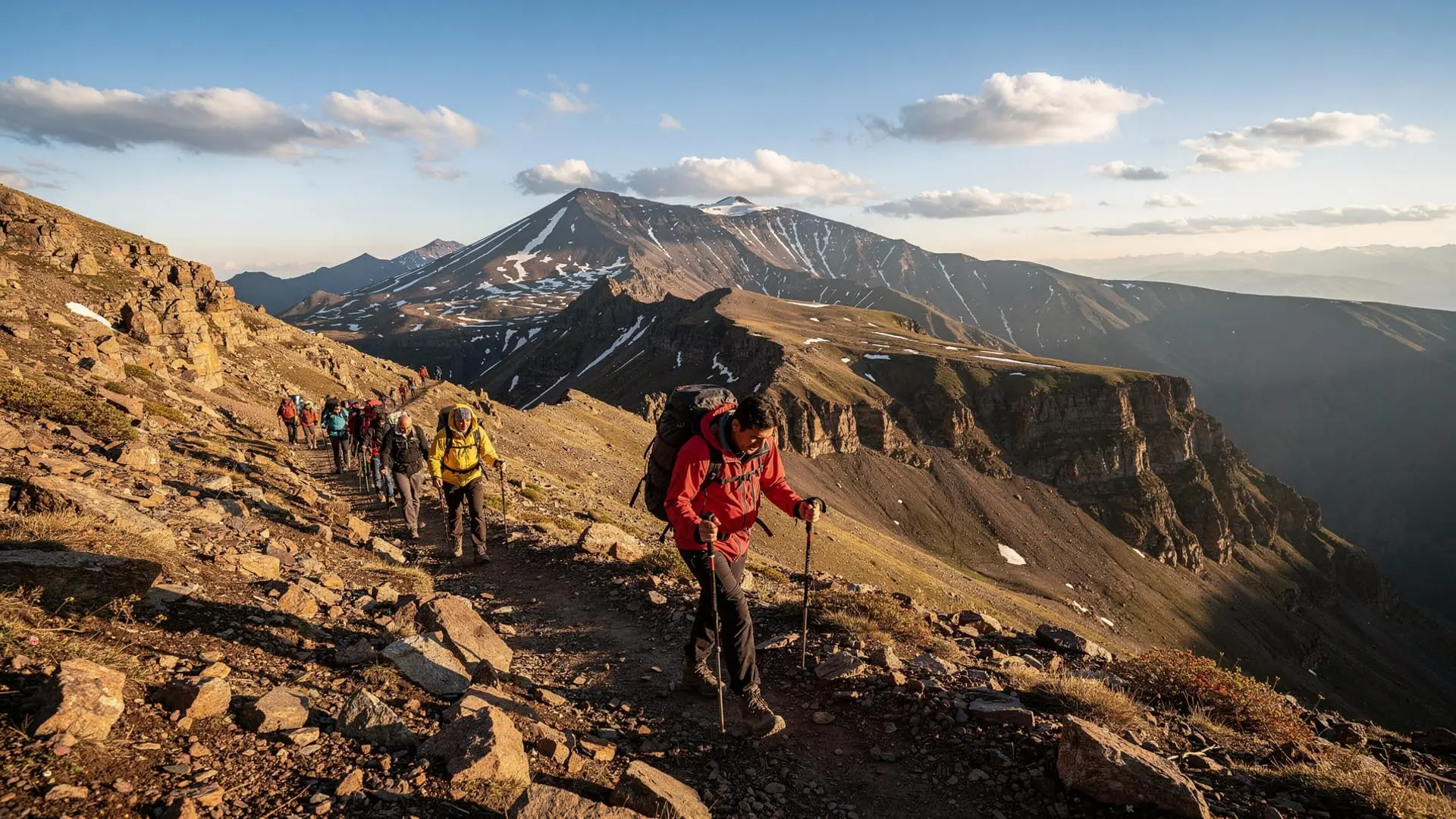
Of Aragats’s four peaks — north (4,090 m), east (3,916 m), south (3,879 m), and west (4,007 m) — the southern summit is consistently described as the most accessible. It has the shortest vertical gain from Lake Kari, a reasonably direct line, and no technical climbing beyond some scrambling on loose volcanic rock near the top. It’s the peak most non-specialist hikers aim for, and on a good day it’s entirely feasible as a day return from Yerevan.
From the lake, the route goes roughly south, following the rim of the outer crater. There is a visible path in the lower section, though it becomes less defined as you gain height. The first hour is a moderate climb across tundra grass and scree — good going, pleasant views back toward the lake and the research station below. By the time you reach the ridge at about 3,500 metres, the southern summit is visible ahead: a rounded pile of dark basalt with a few cairns marking the final approach.
The second hour is the harder section. The path essentially disappears above 3,600 metres and you’re picking a line across loose rocks and occasional snow patches. In May the snow can be consolidated enough to kick steps, or it can be sugary and unstable — ours was the former, which helped. The gradient steepens noticeably in the last 200 metres of vertical before the summit plateau.
We reached the top at 9:15 a.m. — two hours and forty-five minutes from Lake Kari, moving steadily but not rushing. The wind at the summit was cold and intermittent, nothing severe. The views, in the clear morning air, were extraordinary: west into Turkey and the cone of Greater Ararat floating above the haze, north toward Georgia, east across the entirety of the Armenian plateau to Lake Sevan glinting on the far horizon.
The weather window
I want to emphasise the timing, because Aragats’s weather is genuinely unreliable and getting it wrong is unpleasant. By 11:00 a.m., while we were beginning our descent, clouds had started building on the western side. By 12:30 p.m., as we reached the lower tundra, the summit was completely obscured. By 2:00 p.m., back at the car, it was raining at the lake.
This is not unusual. The standard advice — start early, be off the summit by 11:00 or 11:30 — is genuinely good advice, not just caution. Afternoon thunderstorms in May and June can be sudden and severe at this altitude. Lightning on an exposed ridgeline at 3,800 metres is not where you want to be.
The other weather concern specific to May is residual snow on the descent. What I had kicked steps through on the way up was, on the way down, softening in the morning sun and becoming slippery. Trekking poles made a real difference on the loose rock and softened snow of the final descent. Bring them if you have them.
Private guided day hike to the southern summit of Aragats from YerevanWhat to bring
The essentials for a May day on Aragats are: warm layers (temperature at the summit was around 2°C when we arrived), waterproof jacket, trekking poles, crampons or microspikes if there’s been recent snow (we didn’t need them but came close to wishing we had), at least two litres of water per person, and food for a full day since there is nothing to buy above the lake.
Sun protection is important and often overlooked. The UV intensity at 3,800 metres with snow reflection is significant even on a cool day. I got mild sunburn on my neck and lower face despite thinking the overcast haze was protective.
For footwear, genuine hiking boots with ankle support are important — the loose volcanic rock on the upper section would be miserable in trail runners and risky in anything less sturdy. We both wore stiff mountaineering-style boots which were overkill but comfortable.
The broader Aragats context
Mount Aragats is Armenia’s highest point and a source of genuine national significance — the mountain appears on the country’s coat of arms alongside its neighbour, the unclimbable-from-Armenia Greater Ararat. For Armenians, being able to summit Aragats has a different weight than, say, a tourist ticking a peak.
The southern summit we climbed is, as I said, the easiest of the four. The northern summit is the highest and requires a full day with early start and solid mountain experience. The eastern and western peaks are intermediate in difficulty. If you’re seriously considering all four summits, the complete Aragats hiking guide covers the logistics in detail.
The area around Lake Kari is also interesting independently of the summit: the Amberd Fortress is visible from the approach road and worth a short detour, and the Armenian Alphabet Monument at Artashavan is a short drive away and genuinely moving in its own understated way.
The summit experience
I want to say something about what it actually feels like to stand on the southern summit of Aragats in early May, because the description “3,879 metres, good views” doesn’t quite cover it.
The summit plateau is a small area of broken basalt and old snow. There is a metal pole with some Armenian flags, a cairn, and a small visitors book in a waterproof box where you can sign your name. We signed it. There were three signatures already from that morning — one party ahead of us. There were perhaps forty signatures for the entire previous week.
What the views required was time. The first few minutes at the summit, you’re just recovering from the final climb, drinking water, looking around in a general way. Then the specifics come into focus: the crater lake visible to the northeast, deep and blue, with remnant snow along one edge. The four peaks visible as distinct shapes from this angle — north, west, and east higher than where I stood, each one a different distance and texture. The plateau of the Armenian highlands extending in every direction, brown-green at the lower altitudes, silver-grey where the snowmelt was recent. And to the west, barely visible in the morning haze, the flat-topped mass of Greater Ararat across the Turkish border, enormous and motionless-looking, as if it had always been there and always would be.
The political reality of Ararat — visible from Armenian territory but unreachable, the mountain that appears on the Armenian coat of arms but sits in Turkey — is something you feel differently at altitude. From Khor Virap below, Ararat is the postcard view, beautiful and distant. From 3,879 metres, looking at it across 80 kilometres of air, it feels like a genuine presence.
The Aragats context
Mount Aragats is the Armenian Republic’s highest point and carries a weight in the national imagination that goes beyond the topographic. The mountain’s four peaks form a recognisable silhouette on the horizon north of Yerevan; the volcanic massif includes Lake Kari at 3,185 metres, the Amberd Fortress on the lower slopes at around 2,300 metres, and the cosmic ray research station that has occupied the summit plateau since Soviet times. The area around Lake Kari also includes the Armenian Alphabet Monument at Artashavan — worth a short detour on the drive up to see the 39-letter alphabet rendered in stone on the hillside.
The four peaks differ in character as well as altitude. The northern summit (4,090 m) is the highest and most remote, requiring a full mountain day and appropriate skills. The eastern summit (3,916 m) is accessible to experienced hikers but involves more technical ground than the southern. The western summit (4,007 m) is the second highest and requires a longer approach. The southern peak (3,879 m) is consistently the most accessible and is the correct starting point for anyone new to Aragats.
For those wanting to tick multiple peaks in a multi-day trip, camping near Lake Kari is possible and a small number of tour operators run summit-focused overnight trips. The complete Aragats hiking guide covers the planning in detail.
Getting there without a car
Getting to Lake Kari without a private vehicle is possible but not entirely straightforward. Marshrutkas run from Yerevan to Aparan and to Gyumri, but none go directly to the lake. From Aparan, a local taxi to Lake Kari costs roughly 4,000-6,000 AMD each way and you’ll need to arrange a return pickup in advance — there are no taxis waiting at the lake. Several tour operators in Yerevan run guided hikes to Aragats, the advantage being that transport, guide, and logistics are all handled. Given the early start required and the importance of weather assessment, a guided option is worth considering for first-time visitors to the mountain.
For a solo hiker arranging their own transport, factor in at least 40 minutes from Aparan to the lake on the upper track, and note that the road above Byurakan can still carry snow patches in early May, particularly on north-facing sections. We drove a standard sedan with decent ground clearance and managed it without incident; a car with higher clearance would be more comfortable.
One more practical note: the tea sellers at Lake Kari who are set up by the time you arrive serve hot drinks from a thermos and occasionally have simple food. They are there in summer; in early May it depends on the year. Do not rely on them for your nutrition. On our day they were there and the tea was very welcome on the descent; on another day they might not have been.
The day — the summit, the views, the descent through the clearing clouds — was among the better hiking days I’ve had in Armenia, and Armenia has excellent hiking days. The southern summit is genuinely accessible to fit, properly equipped hikers who plan carefully and start early. The emphasis is on starting early.