Mount Aragats & Amberd: high-altitude day trip
Armenia’s highest mountain is not Ararat — that’s in Turkey, visible but unreachable from Armenian soil. Armenia’s highest is Mount Aragats, a four-peaked volcanic massif in Aragatsotn province whose northern summit reaches 4 090 metres. And unlike Ararat, Aragats is fully accessible: you can drive to within walking distance of the southern and northern summits, stop at a crater lake ringed by wildflowers in summer, explore a 10th-century fortress on its slopes, and stand beside 36 stone letters that represent the Armenian alphabet — all in a single day from Yerevan.
This day trip rewards anyone who wants to trade the monastery circuit for mountain air and altitude drama. It also works beautifully as a complement to the monastery routes — Saghmosavank and Hovhannavank, both monasteries carved above canyon walls, sit on the lower Aragats approaches.
What the Aragats day trip covers
The standard version of this day trip chains three main stops:
- Armenian Alphabet Monument (Artashavan village, 1 500 m) — 36 stone letters representing the Armenian alphabet, arranged in a sweeping hillside installation created for the 1 600th anniversary of the Armenian script in 2005.
- Amberd fortress and Vahramashen church (2 300 m) — a well-preserved 10th-century fortress and 11th-century church on a dramatic basalt promontory above the confluence of two gorges.
- Lake Kari (3 200 m) — a high-altitude crater lake at the base of the southern Aragats summit, accessible by road from May to October.
The fourth stop, available to those who want to hike, is the southern summit of Aragats (3 879 m) — about 3–4 hours round trip from the Lake Kari trailhead.
Drive times from Yerevan
- Yerevan → Alphabet Monument (via Aparan): approximately 90 km, 1 hour 30 minutes
- Alphabet Monument → Amberd fortress: 25 km, 30–35 minutes on a narrow mountain road (last section is unpaved but manageable in a normal car in good conditions)
- Amberd → Lake Kari: 12 km further up the mountain, 20–30 minutes. The last 3–4 km gets progressively rougher; 4WD or high-clearance is strongly recommended above 2 800 m when the road is wet or partially frozen.
- Lake Kari → Yerevan: approximately 2 hours return
Total day: 8–10 hours including stops and a lunch break.
Book an Amberd fortress and Lake Kari Aragats day tour
The Armenian Alphabet Monument
The Alphabet Monument outside Artashavan village is often missed by visitors who head straight to the higher slopes. That’s a mistake. The 36 stone letters — each 1.5–2 metres tall, carved from basalt and arranged on a hillside overlooking the Ararat plain — are striking in isolation. But what makes the stop special is the view: on a clear day, Mount Ararat floats on the southern horizon across the plain, with the stone letters of the Armenian alphabet standing between you and the mountain that defines Armenian identity but remains on the other side of a closed border.
Budget 30–45 minutes. The site has parking and a small café in season.
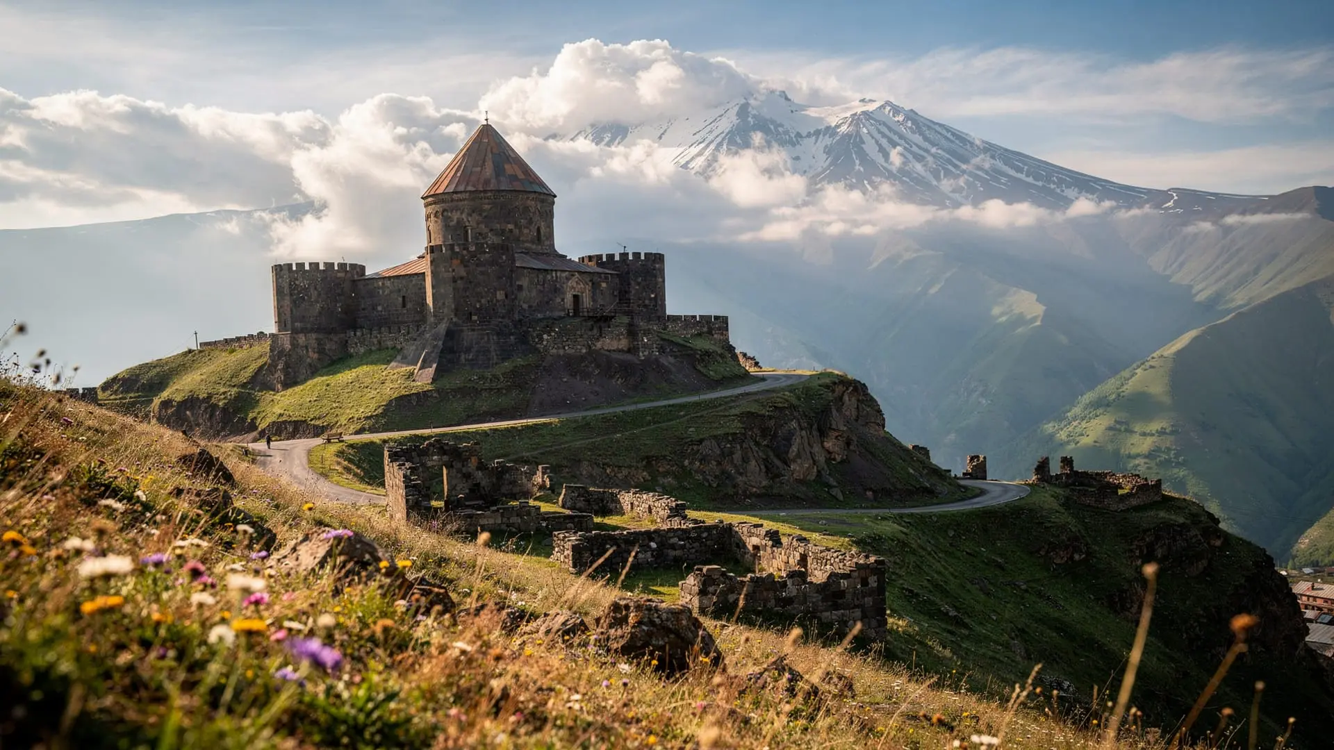
Amberd fortress: the site and its history
Amberd fortress (“Amberd” means “fortress in the clouds” in Armenian) was built in the 7th–10th centuries and served as both a military stronghold and a summer residence for the Bagratid princes of Aragatsotn. It occupies a triangular promontory at the junction of the Arkashen and Amberd rivers, surrounded on two sides by deep gorges that made walls on those flanks largely unnecessary.
What survives is substantial: thick perimeter walls, towers, a palace complex, and immediately adjacent, the Church of Vahramashen (1026 AD) — one of the best-preserved examples of late Bagratid church architecture, with fine stone carving and a complete dome. Entry to the site is free.
Allow 60–90 minutes to walk the perimeter, enter the church, and look down into the gorges. The views of the Aragats massif behind and the Ararat plain below are excellent.
Practical warning: The road to Amberd is unpaved for the last few kilometres and can be muddy after rain. A 4WD handles it easily; a standard car with reasonable ground clearance manages in dry conditions. Avoid after heavy rain.
Lake Kari and the high-altitude experience
Lake Kari (3 200 m) is the emotional centrepiece of the day. This small volcanic crater lake sits in a landscape of tundra and volcanic rock, surrounded in summer by wildflowers and patches of lingering snow. The southern Aragats summit looms above to the north. On a calm summer day it is one of the most serene spots in Armenia.
Visiting Lake Kari:
- Road opening: typically mid-May. Heavy snows can delay this; check conditions before going.
- Road surface: increasingly rough above 2 800 m. The final approach is loose volcanic rock and gravel. A standard car can manage in dry summer conditions if driven carefully, but 4WD is the honest recommendation for peace of mind.
- Weather: changes extremely rapidly at altitude. Blue sky at Amberd can become cloud, fog, or even snow at Lake Kari within 30 minutes. Always bring a waterproof layer regardless of the forecast at lower elevations.
- What’s there: the lake, a small café/shelter in summer, and the base of the Aragats hiking trails. No formal facilities.
Book an Aragats mountain hiking tour from Yerevan
Hiking from Lake Kari
If you want to reach the southern summit of Aragats (3 879 m), the trail from Lake Kari takes 3–4 hours round trip, marked with cairns. The summit itself is a rocky plateau — not dramatic like an alpine peak but sweeping in its views. Altitude sickness is possible for unacclimatised visitors — ascend slowly and turn back if you develop headaches or dizziness.
The northern summit (4 090 m, Armenia’s highest point) requires a longer, more serious approach from a different trailhead. It is not part of the typical day trip. See the Aragats mountain hiking guide for full hiking details.
Adding Saghmosavank and Hovhannavank
For travellers interested in combining the mountain route with monastic architecture, Saghmosavank monastery (meaning “Psalm Monastery”) sits above the Kasakh gorge on the road between Yerevan and the Aragats foothills — it can be visited en route to Amberd without significant detour. Hovhannavank monastery is 10 km away. Together they add 1.5–2 hours to the day.
The Saghmosavank canyon monastery guide and the Hovhannavank guide give the full picture.
Seasonal calendar
| Month | Alphabet Monument | Amberd | Lake Kari |
|---|---|---|---|
| Jan–Mar | Accessible | Accessible | Closed (snow) |
| April | Accessible | Accessible (muddy) | Closed |
| May | Accessible | Accessible | Opens mid-May |
| June–Sept | Accessible | Accessible | Open (best season) |
| October | Accessible | Accessible | Closes late Oct |
| Nov–Dec | Accessible | Accessible | Closed |
What this day costs
| Item | Cost (AMD) | EUR approx. |
|---|---|---|
| Amberd fortress entry | Free | — |
| Lake Kari (no fee) | Free | — |
| GG Taxi round trip with waiting | 30 000–45 000 | ~73–110 |
| Group tour per person | 10 000–18 000 | ~24–44 |
| Lunch (basic café at Lake Kari or Byurakan) | 2 000–5 000 | ~5–12 |
The Aragats area for hikers and non-hikers
One of the strengths of the Aragats day trip is that it works well for very different fitness levels and interests.
For non-hikers: The Alphabet Monument, Amberd fortress, and the Lake Kari views are all accessible without any serious walking. The site of Amberd requires a short 10-minute walk from the parking area; the Lake Kari shore is a 5-minute walk from the road end. These can all be done comfortably in walking shoes.
For casual hikers: From Lake Kari, well-marked trails lead across the volcanic tundra plateau. A 2–3 hour circuit around the lake basin and toward the southwestern ridge of the southern summit is achievable without technical equipment in dry summer conditions. The views are excellent and the landscape — treeless volcanic rock dotted with alpine flowers — is unlike anything in the lower valleys.
For serious hikers: The southern summit (3 879 m) and the northern summit (4 090 m, Armenia’s highest point) require proper footwear, layers, water, and acclimatisation awareness. The southern summit is frequently done in a day from Lake Kari by fit hikers. The northern summit requires a longer approach. See the Aragats hiking guide for full trail descriptions.
Byurakan observatory: the science detour
On the lower southern slope of Aragats, at about 1 480 metres, the Byurakan Astrophysical Observatory was founded by the astronomer Viktor Ambartsumyan in 1946 and became one of the most productive astronomical research centres in the Soviet world. The site features Soviet-era telescope domes, research buildings, and a museum of astronomical history.
Byurakan is not for everyone — it’s primarily interesting to those with a science background or a particular interest in Cold War scientific history. But the mountain setting is beautiful, and the observatory is only 15 km off the main Aragats route, making it a low-effort addition.
Wildflowers on the Aragats slopes
One of the best-kept secrets of the Aragats day trip is the wildflower display in May and early June. As the snow line retreats up the mountain, it’s followed by an advancing carpet of alpine flowers: violet pansies, yellow potentilla, white anemones, and several species of orchid that grow only in these high Armenian meadows.
By July the bloom has faded to summer greens and tans. For wildflower photography, specifically target the Aragats route in mid-May — Yerevan is already warm (20°C+) while the Aragats slopes at 2 000–2 500 m are still in the transition zone between winter and summer. The contrast is extraordinary.
What to eat on the Aragats day trip
Food infrastructure on the upper mountain is minimal. Plan accordingly:
Below 2 000 m (Byurakan, Aparan area): Several restaurants in the villages around Aparan serve traditional Armenian food — khorovats, lavash, herb soups. Budget 3 000–5 000 AMD for a full meal.
At Amberd: No formal restaurant at the fortress site itself. Some vendors operate seasonally near the parking area with cold drinks and basic snacks. Carry your own food for the upper mountain visit.
At Lake Kari (summer only): A simple café/shelter near the lake serves tea, coffee, and very basic food in July–September. Don’t count on it — bring a packed lunch.
The Voskevaz winery stop: For travellers interested in Armenian wine, the Voskevaz winery sits near the base of the Aragats slopes on the road from Yerevan to Aparan. It produces wines from indigenous Armenian grapes including Voskehat and Kangun. A winery stop adds an hour and introduces a very different sensory experience to a day otherwise dominated by stone and altitude.
Frequently asked questions about the Aragats and Amberd day trip
Do I need a 4WD for this trip?
For the Alphabet Monument and Amberd, a standard car is fine in dry conditions. For Lake Kari, a 4WD or high-clearance vehicle is strongly recommended — the last few kilometres of road are rough volcanic rock and can be wet even in summer. Many tour operators use 4WD minibuses for this route. If renting, choose a SUV rather than a sedan.
Can I reach Lake Kari in May?
Sometimes, from mid-May onwards, but check recent reports before going. The road can be blocked by snow in early May even when lower elevations appear clear. Local Facebook groups for Armenia hiking often post road condition updates.
How cold is it at Lake Kari in summer?
The lake sits at 3 200 metres. Summer temperatures range from 5 to 18°C at the water’s edge, with wind chill making it feel colder. Bring a warm layer even in July. Weather can change within minutes.
Is there mobile signal at Lake Kari?
Partial — Ucom and Beeline have some coverage, but it’s unreliable above 3 000 m. Don’t count on navigation apps working above Amberd. Download offline maps (Maps.me or Google Maps offline) before going.
Can I combine Aragats with the Garni and Geghard route?
In theory yes, but it makes for a very long day. Garni and Geghard are east of Yerevan; Aragats is northwest. The combined drive would be 5–6 hours. Better to save these for separate days.
What is the view like from the southern summit?
On a clear day: north to the Greater Caucasus range in Georgia; south across the Ararat plain to Mount Ararat (inside Turkey) and the smaller Ararat (Sis); east toward Lake Sevan; west across the Turkish border to the highlands. The panorama is among the finest in the Caucasus.