Smbataberd Fortress: Vayots Dzor's ridge hike
The fortress nobody goes to — and why that is a good thing
In a country with Tatev, Khor Virap, and Amberd — all served by roads and busy with tour buses in summer — Smbataberd is the fortress that rewards the effort to find it. There are no tour buses. There is no road to the gate. There is barely a sign. What there is, at the top of a 1.5-hour uphill hike from the village of Artabuynk in Vayots Dzor province, is a medieval ridge fortress with walls stretching across a narrow spur above the Yeghegis canyon, and a view that makes the climb feel entirely justified.
Smbataberd — the name means “fortress of Smbat” — dates to the 11th to 13th centuries, with earlier fortifications possibly predating the Bagratuni period. It occupied a commanding position between two river valleys: the Yeghegis to the north and the Artabuynk gorge to the south. Any army moving through this stretch of Vayots Dzor would have been visible from the fortress walls for kilometres in every direction.
Unlike the heavily visited monasteries of southern Armenia, Smbataberd has no entrance fee, no souvenir sellers, and no cafes. On most weekdays in spring and autumn, you will be alone with the walls, the wind, and the view.
| Where | Artabuynk village, Yeghegis valley, Vayots Dzor (155 km from Yerevan) |
| Cost | Free (no entrance fee); around 20,000–25,000 AMD for a private taxi from Yeghegnadzor if you have no car |
| Time needed | 4 hours round trip, including time at the fortress |
| Getting there | Self-drive strongly recommended; 2.5 hours from Yerevan via Yeghegnadzor |
| Best time | Late May–June or September, early morning start |
History of Smbataberd
Origins and name: The fortress is named for Smbat, one of the princes of the Bagratuni dynasty — the same royal family that built the medieval Armenian kingdom with its capital at Ani (now in Turkey). The exact Smbat commemorated in the name is debated by historians, but the fortress is generally dated to the 11th century based on construction technique and historical references.
Bagratuni and Orbelyan periods: The fortress passed from Bagratuni control to the Orbelyan family, a powerful Armenian noble dynasty that dominated Vayots Dzor from the 13th to 15th centuries. The Orbelyans were significant patrons of the arts and architecture — they built Noravank monastery, visible from the road 15 km away, and commissioned the famous sculptor Momik, who carved the extraordinary gavit (narthex) at Noravank. The fortification at Smbataberd served as the military anchor for the Orbelyan domain in Vayots Dzor.
Military function: Smbataberd controlled the Yeghegis valley, one of the main routes through Vayots Dzor connecting the Ararat plain to the south and Syunik province. It was not a royal residence but a military installation — garrison walls, towers, and cisterns, without the churches and scriptoria that characterised the great monastery-fortresses. Its function was entirely defensive.
Decline: The fortress lost its strategic significance after the Mongol period reshaped power structures in the region. By the late medieval period it had been abandoned. No significant reconstruction or occupation followed. Today the walls and towers survive in ruined but photogenic condition — substantial enough to read the original layout, damaged enough to be atmospheric rather than museum-like.
Nearby Yeghegis Jewish cemetery: Three kilometres north of the Smbataberd trailhead lies the Yeghegis medieval Jewish cemetery — one of the most unexpected historical discoveries in Armenia, a burial ground of the Jewish community that lived in this valley during the 13th-14th centuries, with tombstones inscribed in Hebrew. It is worth 30 minutes of your time on the same visit, though the site requires some searching to locate.
The hike: route description
Starting point: The village of Artabuynk, in the Yeghegis valley of Vayots Dzor, approximately 155 km from Yerevan (about 2.5 hours by car via Yeghegnadzor).
Distance and elevation: The trail from the village to the fortress is approximately 3.5 km one way, with about 400 metres of elevation gain. The trailhead is at roughly 1,700m; the fortress sits at approximately 2,100m. This is a steady uphill with no technical sections — the difficulty is sustained gradient rather than exposure or scrambling.
Trail surface and markers: The path follows a clear worn track from Artabuynk, initially through cultivated fields at the village edge, then onto open hillside. There are no formal trail markers, but the path is visible on the ground. In summer the grass on either side of the track grows tall, but the route is not in doubt. The final approach to the fortress walls crosses rocky terrain where the path briefly becomes less defined — trend uphill toward the visible walls.
Duration: 1 to 1.5 hours ascending, depending on fitness and how often you stop for the view. The descent is 45-60 minutes. Budget 4 hours total for the round trip with time at the fortress (30-45 minutes at minimum to walk the full wall circuit).
Exposure: The upper third of the trail is on an open ridge with no shade. In summer (June-August), this section is hot by mid-morning. Start early (before 9 AM) to reach the top before the worst heat. In spring (April-May) and autumn (September-October), this is not a concern.
Season: The hike is accessible from late April to early November. Snow can lie on the upper section into early April, making the final approach to the walls slippery. In July-August the trail is dry and the views are long but the heat is significant on the exposed ridge. The ideal window is May-June and September-October: mild temperatures, vegetation at its most colourful, and the canyon air clean and clear.
Winter: Not recommended without specialised equipment. The approach road to Artabuynk can be snow-covered, and the trail above is icy. Smbataberd is a genuine four-season hike only in the April-November window.
What to see at the fortress
The walls and towers: The perimeter wall of Smbataberd runs along the natural ridge line, using the terrain to amplify its defensive effect — the southern face drops sharply, making any assault from that direction extremely difficult. The walls are of dry-stone construction reinforced with mortar in sections, with several towers at the corners and at the gatehouse. The walls stand to a height of 3-5 metres in the best-preserved sections, substantially collapsed in others.
Walk the full perimeter of the wall if time and surface condition permit. The eastern end is better preserved than the western; the northern wall, facing the more accessible slope, shows signs of the strongest defensive reinforcement.
The gate: The main gateway is on the northeast face — the direction of least natural protection, requiring the most architectural defence. The gatehouse is ruined but identifiable.
Interior structures: The interior of the fortress is rough ground with the remains of several internal structures — likely garrison buildings and cisterns. These are not clearly identifiable without archaeological knowledge. The cisterns (water storage) were essential for siege survival — look for stone-lined depressions in the interior.
The view: This is the real reason to climb. From the walls of Smbataberd, the Yeghegis canyon opens below to the north — a deep, forested gorge with the river visible as a silver line far below. The canyon walls are red-gold volcanic rock, not dissimilar in palette to the famous cliffs around Noravank further south. To the south, the Artabuynk valley falls away toward the Vayots Dzor plateau. On clear days, the ridgelines of Syunik province are visible to the southeast. The combination of medieval masonry in the foreground and geological canyon landscape in the background is one of the better viewpoints in southern Armenia.
Tsakhats Kar monastery: the circuit extension
Two kilometres north of Smbataberd, accessible from the same valley, lies the monastery of Tsakhats Kar — “cross carved in stone,” a name derived from a large cross cut into the cliff face near the site. The monastery dates to the 10th-11th century and is in a quieter, more forested setting than Smbataberd, with several khachkars (cross-stones) in the surrounding area.
Tsakhats Kar is reachable by a separate approach from the Yeghegis valley floor — it is not directly connected to the Smbataberd trail, and combining both sites as a single loop requires navigation skills and a longer day (approximately 7-8 hours total). For most visitors, the practical approach is to visit Tsakhats Kar first (by car to the base of its approach, then a short walk), then drive to Artabuynk and do the Smbataberd hike.
Together, Tsakhats Kar and Smbataberd make a compelling half-day that covers both religious and military medieval heritage in the Yeghegis valley — entirely off the mainstream tourist circuit.
Where to stay for a Smbataberd trip
Yeghegnadzor is the practical base: the provincial capital sits roughly 20 km from Artabuynk and has the widest range of guesthouses and small hotels in Vayots Dzor, plus fuel stations, a supermarket, and restaurants for the evening after the hike. Staying here rather than driving up from Yerevan the same morning removes the early-alarm pressure and lets you start the hike by 8–9am, before the heat builds on the exposed ridge.
Areni village, closer to Noravank and the wineries, is the alternative base if you are combining Smbataberd with a wine-focused day — it has a smaller but growing guesthouse scene and puts you 30 minutes closer to the Noravank canyon for a relaxed sunset visit after the hike.
Both options beat a same-day round trip from Yerevan, which works but leaves less margin for the unpredictable elements of this route: an unpaved final stretch, no phone signal, and a hike that rewards an unhurried pace rather than a clock-watching one.
Getting to Smbataberd
From Yerevan by car: 155 km, approximately 2.5 hours. Take the M2 south through Ararat province, then east via Yeghegnadzor on the H43. From Yeghegnadzor, follow the road into the Yeghegis valley toward Yeghegis village and Artabuynk. The road is paved to Yeghegis village; the final few kilometres to Artabuynk may be unpaved but passable in a standard car in dry conditions.
By organised tour: Smbataberd is rarely included in standard tour itineraries, which is part of its appeal. A few operators offer off-road or adventure day trips into the Yeghegis valley.
Smbataberd and Zorats Church off-road day trip from YerevanBy public transport: Not directly feasible. A marshrutka runs from Yerevan to Yeghegnadzor; from there, a taxi to Artabuynk is necessary (approximately 20 km from Yeghegnadzor). Arrange the return taxi in advance or ask the driver to wait.
Self-drive recommendation: Renting a car in Yerevan is strongly recommended for a Vayots Dzor itinerary. The flexibility to combine Smbataberd, the Yeghegis valley, Noravank, Areni wine country, and return at your own pace is not achievable any other way. See renting a car in Armenia guide for practical information.
Combining Smbataberd with other Vayots Dzor sites
The Yeghegis valley and the broader Vayots Dzor province contain enough for a full day or a comfortable overnight:
- Noravank monastery (30 km south, 40 min drive): the most dramatic monastery in Vayots Dzor, set in a narrow red rock canyon — see Noravank monastery guide. Essential. Allow 2 hours.
- Areni village and winery (35 km south, 50 min): Armenia’s wine heartland. The Areni-1 Cave (site of the world’s oldest winery) is nearby — see Areni-1 cave guide. Wine tasting at Hin Areni or Areni Wine Factory.
- Jermuk spa town (50 km east, 1 hour): Armenia’s famous thermal waters resort, with a mineral water gallery and a waterfall — see Jermuk spa guide. Good for a second night.
- Vayots Dzor wine route (covers the whole province): see Vayots Dzor wine route guide.
- Yeghegis Jewish cemetery (3 km north of Artabuynk): 13th-14th century Jewish tombstones with Hebrew inscriptions — unusual and worth 30 minutes.
A logical Vayots Dzor day from Yerevan: Noravank (mid-morning) → Areni wine tasting (lunch) → Yeghegis Jewish cemetery (early afternoon) → Smbataberd hike (afternoon, finish by 6 PM) → return to Yerevan or stay overnight in Yeghegnadzor.
This is a full day. Alternatively, stay two nights in Yeghegnadzor and do Smbataberd as a dedicated hiking day, combining it with Tsakhats Kar.
What to bring for the hike
- Hiking boots: The rocky terrain in the final section to the walls makes trail shoes or boots essential. Sneakers will work on the lower trail but are uncomfortable on the upper rocks.
- Water: At least 1.5 litres per person. There is no water source on the trail or at the fortress. The village of Artabuynk does not have a reliable shop — carry water from Yeghegnadzor.
- Sun protection: The upper trail is fully exposed. Hat, sunscreen, and sunglasses are essential in summer.
- Snack or lunch: No food is available at the site. Bring your own; eating on the fortress walls with the canyon view below is one of the better lunches you can have in Armenia.
- Navigation: Download the trail to Maps.me or Gaia GPS before departure — mobile signal is unreliable in the Yeghegis valley. The trail is clear but the approach to Artabuynk village from Yeghegnadzor has some ambiguous junctions.
- Camera: The fortress walls as a foreground against the canyon are one of the better medieval landscape compositions in southern Armenia.
Safety and mobile signal on the approach
The Yeghegis valley is genuinely remote by Armenian standards, and a few safety notes are worth taking seriously before you set off. Mobile signal is patchy from Yeghegnadzor onward and effectively absent on the trail itself — do not rely on a live map or on calling for help once you leave Artabuynk. Tell your Yeghegnadzor or Goris accommodation your plan and rough return time if you are hiking solo.
The trail has no barriers at the fortress walls, and several sections of the perimeter drop steeply into the canyon below. This is not a concern for anyone paying normal attention, but it is worth mentioning for hikers with children or anyone uneasy near unguarded drops — supervise closely on the wall circuit. There is no mountain rescue infrastructure comparable to the Alps; the practical safety net is simply not hiking alone in poor weather, carrying enough water, and turning back if a summer thunderstorm builds over the ridge (lightning on an exposed spur is a real risk — Vayots Dzor storms can arrive quickly in July and August afternoons).
If you are combining Smbataberd with the Yeghegis Jewish cemetery or the Tsakhats Kar monastery detour described above on the same day, build in a buffer: the unpaved final stretch to Artabuynk and the unmarked side paths around Tsakhats Kar both take longer than GPS distance suggests. For the wider Vayots Dzor picture, see the Vayots Dzor wine route guide.
None of this makes Smbataberd a dangerous hike — thousands of visitors complete it without incident every season — but it is a genuine hill walk in a genuinely remote valley, not a paved viewpoint car park, and it deserves the same basic preparation any moderate mountain trail would.
Drone flying at Smbataberd
The aerial view of Smbataberd — the narrow ridge walls surrounded by canyon on both sides — is striking, and several drone shots of the site circulate online. Armenia has no general prohibition on drone flying in rural areas away from airports and military zones. Smbataberd is not a restricted area, and drone use is practised here. Standard considerations apply: do not fly over people, stay below 120m above ground level, and be aware that the ridge winds can be strong and unpredictable. A DJI Mini-size drone is manageable; larger drones should be flown cautiously in gusty conditions.
Why Smbataberd and not Tatev or Khor Virap?
This is not an either-or question. Tatev Monastery and Khor Virap are essential Armenia — every visitor should see them. But for travellers who have already done the main southern circuit, or who want one experience that is genuinely not on the tourist trail, Smbataberd offers something the famous sites cannot: solitude.
On a weekday morning in May, it is entirely normal to do the entire Smbataberd hike and spend 30 minutes at the fortress without seeing another person. The views of the Yeghegis canyon from the walls are not inferior to the famous views from other sites — they are simply unknown.
This is the honest case for Smbataberd: not the most dramatic castle, not the oldest, not the most architecturally complex. But it rewards effort, it is free, it is almost always quiet, and the hike through Vayots Dzor’s volcanic landscape is beautiful in its own right regardless of what you find at the top.
For hikers, the trail itself is the point as much as the destination. The 3.5 km ascent through increasingly alpine terrain — starting in cultivated fields, rising through juniper scrub, arriving at open rocky ridge — gives a genuine sense of earning the view.
Frequently asked questions about Smbataberd
How difficult is the hike to Smbataberd?
Moderate. The trail is 3.5 km one way with 400m elevation gain — sustained uphill but no technical sections, no scrambling, and no exposure to heights (the ridge walk to the walls is wide). Anyone who is reasonably fit and comfortable with 3-4 hour hill walks will manage it without difficulty. Hiking boots are recommended for the rocky upper section; trail runners are adequate on dry ground. Children aged 10 and above who are accustomed to walking uphill can do this hike.
Is there drinking water on the trail?
No. There are no springs, streams, or water sources on the trail between Artabuynk and the fortress. Carry a minimum of 1.5 litres per person. In summer, 2 litres is safer given the exposed upper section. Do not count on being able to refill in Artabuynk village — buy water in Yeghegnadzor before you begin the drive to the valley.
Can I visit with young children?
With children aged 8-10 and above who are confident walkers, yes. The trail is long and uphill, which rules it out for small children. For families with younger children who still want to see the fortress, the lower part of the trail (first 1-1.5 km from Artabuynk) offers good landscape and some views of the canyon before the trail steepens — you can turn back at a natural rest point without completing the ascent.
Is drone flying permitted at Smbataberd?
Armenia has no general prohibition on drone flying in rural areas, and Smbataberd is not in a restricted zone. Drone use is practised at the site. Standard precautions apply: the ridge is exposed to wind, so fly conservatively and check conditions before launching. Do not fly over other visitors.
What is the best season to hike Smbataberd?
Late May and September are the best months. Late May combines comfortable temperatures, green vegetation, and reliably clear skies. September is drier, the canyon turns golden-amber, and the light is extraordinary for photography. June-August works but the exposed upper trail is hot by mid-morning — start early. April can have residual snow on the upper section. October is good but check the approach road for mud after rain. November onwards: the trail is accessible on dry days but the road to Artabuynk may be closed after heavy rain or early snow.
How does Smbataberd compare to other fortress hikes in Armenia?
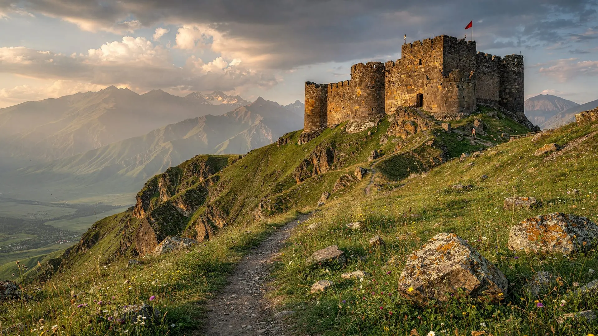
The main comparable hike is Amberd Fortress (on Aragats slopes) — similar elevation gain, similar medieval fortress at the top, but Amberd has a road to within 500m and is far more visited. Smbataberd is more remote, less visited, and the canyon setting is more dramatic than Amberd’s plateau setting. For hikers specifically, the Smbataberd trail is a better hike; for architecture and completeness, Amberd has the better-preserved church. See Amberd Fortress on the slopes of Aragats for comparison.
Is there mobile signal on the Smbataberd trail?
No, or very little. Coverage is unreliable from Yeghegnadzor onward and effectively absent on the trail between Artabuynk and the fortress. Download offline maps (Maps.me or Gaia GPS) before you leave, and let someone at your accommodation know your rough return time — there is no organised mountain rescue service to rely on.
Can I do Smbataberd as part of a Yerevan day trip without staying overnight?
Yes, but only if you commit to a genuinely early start. Leaving Yerevan by 6:30–7am gets you to Artabuynk by around 9:30am, giving enough daylight for the hike plus a stop at Noravank or Areni on the way back. It makes for a long day (12+ hours round trip) — an overnight in Yeghegnadzor or Goris is far more comfortable if your schedule allows it.